Difference between revisions of "2013-12-09 32 -117"
From Geohashing
imported>LucasBrown ([live picture] Map at the hashpoint) |
imported>FippeBot m (Location) |
||
| (3 intermediate revisions by one other user not shown) | |||
| Line 1: | Line 1: | ||
| + | {{meetup graticule | lat=32 | lon=-117 | date=2013-12-09}} | ||
| − | |||
| − | |||
| − | |||
| − | |||
| − | |||
| − | |||
| − | |||
| − | |||
| − | |||
| − | |||
| − | |||
| − | |||
| − | |||
| − | |||
| − | |||
| − | |||
__NOTOC__ | __NOTOC__ | ||
== Location == | == Location == | ||
| − | + | A grove between I-8 and the San Diego River immediately west of a cluster of baseball diamonds, in turn just west of Hotel Circle, San Diego, CA | |
== Participants == | == Participants == | ||
| − | + | [[User:LucasBrown|LucasBrown]] | |
| − | |||
| − | |||
| − | |||
| − | |||
| − | |||
| − | |||
| − | |||
| − | |||
| − | |||
| − | |||
== Photos == | == Photos == | ||
| − | |||
| − | |||
| − | |||
<gallery perrow="5"> | <gallery perrow="5"> | ||
| − | |||
Image:2013-12-09_32_-117_15-12-32-940.jpg | Map at the hashpoint | Image:2013-12-09_32_-117_15-12-32-940.jpg | Map at the hashpoint | ||
| + | Image:2013-12-09_32_-117_15-13-12-595.jpg | Geohash Droid details page at the hashpoint | ||
| + | Image:2013-12-09_32_-117_15-13-53-324.jpg | Sign posted at the hashpoint | ||
</gallery> | </gallery> | ||
== Achievements == | == Achievements == | ||
{{#vardefine:ribbonwidth|800px}} | {{#vardefine:ribbonwidth|800px}} | ||
| − | + | {{Consecutive geohash | count = 2 | latitude = 32 | longitude = -116 | date = 2013-12-08 | name = LucasBrown}} | |
| + | (See also [[2013-12-08 32 -116]]) | ||
| − | |||
| − | |||
| − | |||
| − | |||
| − | |||
| − | |||
| − | |||
| − | |||
| − | |||
| − | |||
| − | |||
[[Category:Expeditions]] | [[Category:Expeditions]] | ||
| − | |||
[[Category:Expeditions with photos]] | [[Category:Expeditions with photos]] | ||
| − | |||
| − | |||
| − | |||
| − | |||
| − | |||
[[Category:Coordinates reached]] | [[Category:Coordinates reached]] | ||
| − | + | {{location|US|CA|SD}} | |
| − | |||
| − | |||
| − | |||
| − | |||
| − | |||
| − | |||
| − | |||
| − | |||
| − | |||
| − | |||
| − | |||
| − | |||
| − | |||
| − | |||
| − | |||
| − | |||
| − | |||
Latest revision as of 04:52, 14 August 2019
| Mon 9 Dec 2013 in 32,-117: 32.7612210, -117.1935631 geohashing.info google osm bing/os kml crox |
Location
A grove between I-8 and the San Diego River immediately west of a cluster of baseball diamonds, in turn just west of Hotel Circle, San Diego, CA
Participants
Photos
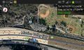
Map at the hashpoint
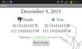
Geohash Droid details page at the hashpoint
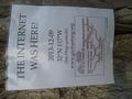
Sign posted at the hashpoint


Achievements
LucasBrown earned the Consecutive geohash achievement
|
(See also 2013-12-08 32 -116)