Difference between revisions of "2013-12-19 43 -116"
imported>Eldin (initial page creation.) |
imported>FippeBot m (Location) |
||
| (2 intermediate revisions by one other user not shown) | |||
| Line 1: | Line 1: | ||
| − | |||
| − | |||
| − | |||
| − | |||
| − | |||
| − | |||
| − | |||
| − | |||
| − | |||
| − | |||
{{meetup graticule | {{meetup graticule | ||
| lat=43 | | lat=43 | ||
| Line 15: | Line 5: | ||
}} | }} | ||
| − | |||
__NOTOC__ | __NOTOC__ | ||
| Line 33: | Line 22: | ||
== Photos == | == Photos == | ||
| − | |||
| − | |||
| − | |||
<gallery perrow="5"> | <gallery perrow="5"> | ||
| + | File:2013-12-19 43 -116 proof.jpg | Proof of reaching the coordinates. | ||
| + | File:2013-12-19 43 -116 grin.jpg | Me, at the hash. | ||
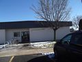
| + | File:2013-12-19 43 -116 apartments.jpg | The apartment complex where the hash was located. | ||
| + | File:2013-12-19 43 -116 raptors.jpg | RAPTOR RESEARCH CENTER! I hope they're taking appropriate precautions in their research... | ||
</gallery> | </gallery> | ||
== Achievements == | == Achievements == | ||
{{#vardefine:ribbonwidth|800px}} | {{#vardefine:ribbonwidth|800px}} | ||
| − | {{Walk geohash|name=[[User:Eldin|Eldin]]|date=2013-12-19|latitude=43|longitude=-116| | + | {{Walk geohash|name=[[User:Eldin|Eldin]]|date=2013-12-19|latitude=43|longitude=-116|distance=3.2 miles}} |
| − | + | {{Land geohash|name=[[User:Eldin|Eldin]]|date=2013-12-19|latitude=43|longitude=-116}} | |
| − | |||
| − | |||
| − | |||
| − | |||
| − | |||
| − | |||
| − | |||
| − | |||
| − | |||
[[Category:Expeditions]] | [[Category:Expeditions]] | ||
| − | |||
[[Category:Expeditions with photos]] | [[Category:Expeditions with photos]] | ||
| − | |||
| − | |||
| − | |||
| − | |||
| − | |||
[[Category:Coordinates reached]] | [[Category:Coordinates reached]] | ||
| − | + | {{location|US|ID|AA}} | |
| − | |||
| − | |||
| − | |||
| − | |||
| − | |||
| − | |||
| − | |||
| − | |||
| − | |||
| − | |||
| − | |||
| − | |||
| − | |||
| − | |||
| − | |||
| − | |||
| − | |||
Latest revision as of 04:57, 14 August 2019
| Thu 19 Dec 2013 in 43,-116: 43.6085369, -116.2143286 geohashing.info google osm bing/os kml crox |
Location
In an apartment complex near Boise State University.
Participants
Plans
This one is too close to miss. Plan to walk there on my lunch break.
Expedition
When my lunch break arrived, I set out on foot. I first met some friends to actually eat lunch, but since the place we met was aproximately on the way from my office to the hash, this was fine. After eating lunch, I continued on foot towards the hash. The walk to the hashpoint was relatively uneventful, and the hashpoint itself was easy to reach, being in a parking space at the Morrison Park Apartments. I arrived there, and took a few pictures. Then I went to hang up a geohash marker (one of the posters from http://geo.crox.net/), at which point a man wearing an ID badge identifying him as working for the company that runs the apartments came up to me and told me that "You can't hang things here", and then scowled at me until I left. As I was walking back to my office, I passed by a building with a sign reading "Raptor Research Center", which was within a few hundred feet of the hashpoint. I looked around for signs of raptors, but fortunately did not find any.
Photos
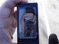
Proof of reaching the coordinates.
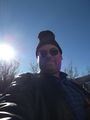
Me, at the hash.

The apartment complex where the hash was located.
RAPTOR RESEARCH CENTER! I hope they're taking appropriate precautions in their research...


Achievements
Eldin earned the Walk geohash Achievement
|
Eldin earned the Land geohash achievement
|