Difference between revisions of "2013-12-25 35 -119"
imported>Bravissimo594 ([live picture] Boppy5 and Tosca nearby. [http://www.openstreetmap.org/?lat=35.06970000&lon=-119.08500000&zoom=16&layers=B000FTF @35.0697,-119.0850]) |
imported>Bravissimo594 (No bunnies to play with. :-( [http://www.openstreetmap.org/?lat=35.06950000&lon=-119.08400000&zoom=16&layers=B000FTF @35.0695,-119.0840]) |
||
| Line 50: | Line 50: | ||
Image:2013-12-25_35_-119_12-25-01-136.jpg | Boppy5 and Tosca nearby. [http://www.openstreetmap.org/?lat=35.06970000&lon=-119.08500000&zoom=16&layers=B000FTF @35.0697,-119.0850] | Image:2013-12-25_35_-119_12-25-01-136.jpg | Boppy5 and Tosca nearby. [http://www.openstreetmap.org/?lat=35.06970000&lon=-119.08500000&zoom=16&layers=B000FTF @35.0697,-119.0850] | ||
| + | |||
| + | Image:2013-12-25_35_-119_12-25-53-417.jpg | No bunnies to play with. :-( [http://www.openstreetmap.org/?lat=35.06950000&lon=-119.08400000&zoom=16&layers=B000FTF @35.0695,-119.0840] | ||
</gallery> | </gallery> | ||
Revision as of 20:25, 25 December 2013
| Wed 25 Dec 2013 in 35,-119: 35.0694823, -119.0841345 geohashing.info google osm bing/os kml crox |
Location
An agricultural field east of Maricopa, CA, near State Route 166 and no too far from Interstate 5.
Participants
Plans
We will drive up from the Los Angeles, California, graticule and see if the farm roads are accessible. The dogs might get to play with any hares they find around there too. I expect to arrive sometime around 11:00am and stay until about 11:30. Then it we will try to hit the Tehachapi meetup point a couple of hours later, possibly with a lunch stop along the way.
If things go really smoothly, the Ridgecrest meetup point might be within reach too. But that would be an ambitious Christmas day.
Expedition
Tracklog
Photos

On the spot in an open field. @35.0695,-119.0840
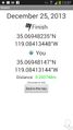
Geohash Droid at the spot.

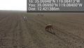
Boppy5 and Tosca nearby. @35.0697,-119.0850
No bunnies to play with. :-( @35.0695,-119.0840


Achievements