Difference between revisions of "2013-12-25 49 -124"
From Geohashing
imported>Rex Wolf (Added expedition details) |
imported>Rex Wolf (Updated expedition report) |
||
| Line 34: | Line 34: | ||
== Expedition == | == Expedition == | ||
<!-- how it all turned out. your narrative goes here. --> | <!-- how it all turned out. your narrative goes here. --> | ||
| + | We drove along for a while, crossed the bridge southwards over the Nanaimo River... and found a gate on the other side. With not one, but FOUR signs. All of which I recorded. | ||
== Tracklog == | == Tracklog == | ||
<!-- if your GPS device keeps a log, you may post a link here --> | <!-- if your GPS device keeps a log, you may post a link here --> | ||
| + | [[:Image:Rex-PortAlberni-2013-12-25-tracklog.png|Rex's tracklog as PNG.]] | ||
== Photos == | == Photos == | ||
| Line 43: | Line 45: | ||
--> | --> | ||
<gallery perrow="5"> | <gallery perrow="5"> | ||
| + | Image:Rex-PortAlberni-2013-12-25-1.JPG | Downstream. | ||
| + | Image:Rex-PortAlberni-2013-12-25-2.JPG | Upstream. | ||
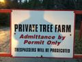
| + | Image:Rex-PortAlberni-2013-12-25-3.JPG | Sign #1. | ||
| + | Image:Rex-PortAlberni-2013-12-25-4.JPG | Sign #2. | ||
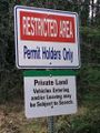
| + | Image:Rex-PortAlberni-2013-12-25-5.JPG | Sign #3. | ||
| + | Image:Rex-PortAlberni-2013-12-25-6.JPG | Sign #4. | ||
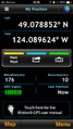
| + | Image:Rex-PortAlberni-2013-12-25-7.PNG | GPS readout. | ||
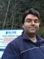
| + | Image:Rex-PortAlberni-2013-12-25-8.JPG | Mugshot. | ||
</gallery> | </gallery> | ||
Revision as of 03:02, 18 January 2014
| Wed 25 Dec 2013 in Port Alberni: 49.0694823, -124.0841345 geohashing.info google osm bing/os kml crox |
Location
In a field or clearing south of the Nanaimo River, near South Nanaimo River Road.
Participants
Plans
I convinced my family to drive out here on Christmas Day, to get us out of the house and enjoy some fresh air.
Expedition
We drove along for a while, crossed the bridge southwards over the Nanaimo River... and found a gate on the other side. With not one, but FOUR signs. All of which I recorded.
Tracklog
Photos
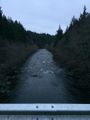
Downstream.
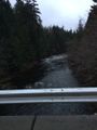
Upstream.
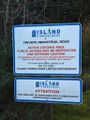
Sign #1.
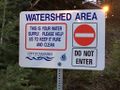
Sign #2.
Sign #3.
Sign #4.
GPS readout.
Mugshot.


