Difference between revisions of "2014-01-04 48 -122"
imported>Rex Wolf (Created expedition page) |
imported>FippeBot m (Location) |
||
| (3 intermediate revisions by one other user not shown) | |||
| Line 1: | Line 1: | ||
| + | {{Advert}} | ||
<!-- If you did not specify these parameters in the template, please substitute appropriate values for IMAGE, LAT, LON, and DATE (YYYY-MM-DD format) | <!-- If you did not specify these parameters in the template, please substitute appropriate values for IMAGE, LAT, LON, and DATE (YYYY-MM-DD format) | ||
| Line 13: | Line 14: | ||
| lon=-122 | | lon=-122 | ||
| date=2014-01-04 | | date=2014-01-04 | ||
| + | | graticule_name=Bellingham | ||
| + | | graticule_link=Bellingham, Washington | ||
}} | }} | ||
| Line 19: | Line 22: | ||
== Location == | == Location == | ||
<!-- where you've surveyed the hash to be --> | <!-- where you've surveyed the hash to be --> | ||
| + | Just off route 20 on Whidbey Island. | ||
== Participants == | == Participants == | ||
<!-- who attended: If you link to your wiki user name in this section, your expedition will be picked up by the various statistics generated for geohashing. You may use three tildes ~ as a shortcut to automatically insert the user signature of the account you are editing with. | <!-- who attended: If you link to your wiki user name in this section, your expedition will be picked up by the various statistics generated for geohashing. You may use three tildes ~ as a shortcut to automatically insert the user signature of the account you are editing with. | ||
--> | --> | ||
| + | *[[User:Rex Wolf|Rex Wolf]] ([[User talk:Rex Wolf|talk]]) | ||
== Plans == | == Plans == | ||
<!-- what were the original plans --> | <!-- what were the original plans --> | ||
| + | I thought I'd take the ferry out to Whidbey Island and try to get this hash. While I was at it, I'd try to haul a friend along. | ||
== Expedition == | == Expedition == | ||
<!-- how it all turned out. your narrative goes here. --> | <!-- how it all turned out. your narrative goes here. --> | ||
| + | I was able to persuade my friend to come out to the hashpoint with me, so we set off. We happened to drive up to the ferry terminal just as they were loading for Whidbey, so we basically drove off the street and straight into the ferry. | ||
| + | |||
| + | I looked around out front, then went up to see what amenities the ferry had. It had a nice cafeteria area and all, but to my surprise, we were only about 20 minutes on the water in total before we were offloading on Whidbey. Kinda makes me wonder why they have food services at all, but I guess it could be nice for people who only want to grab something quick, like a sandwich? | ||
| + | |||
| + | When we got off the ferry, we decided to look for food on the way there. All we saw was a Dairy Queen, so we kept driving. And before we knew it, there wasn't much else but bush around us. I had looked ahead and noted that there didn't seem to be much room at the side of the road near the hashpoint, but on this section of road, there was a normal shoulder. My friend assured me it would be like this up near the hashpoint, too. | ||
| + | |||
| + | Of course, when we got near the hashpoint, the shoulder had completely disappeared. Finding a place to park the car was somewhat more challenging, but we found a driveway nearby that offered enough room to park the car for ten minutes or so. At this point, my friend begged off, because he didn't feel like walking, wanted a smoke, and was going to stay with the car "just in case it needed to be moved." Pooh! | ||
| + | |||
| + | I walked the rest of the way to the hashpoint myself and dove into the bush as I usually do. The cold weather had dried out a lot of this stuff, and it was brittle. Thankfully, it wasn't prickly, this time, and finding my way around was just a matter of making sure I didn't soak my feet by blundering into puddles or streams under the fallen leaves and other plant debris. | ||
| + | |||
| + | Once I posted the sign and took the necessary proofs, I just retraced my steps to get back to the road and headed back to the car. We did stop at the Dairy Queen on the way back, and had to wait about 20 minutes for the return ferry, but otherwise everything worked out very nicely, with the sun setting as we docked back on the Mukilteo side. | ||
== Tracklog == | == Tracklog == | ||
| Line 38: | Line 55: | ||
--> | --> | ||
<gallery perrow="5"> | <gallery perrow="5"> | ||
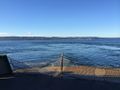
| + | Image:Rex-Bellingham-2014-01-04-1.JPG | On the way to Whidbey. | ||
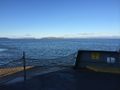
| + | Image:Rex-Bellingham-2014-01-04-2.JPG | I think that's Gedney and Camano Islands in the distance... | ||
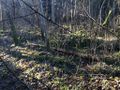
| + | Image:Rex-Bellingham-2014-01-04-3.JPG | Into the bush I go! | ||
| + | Image:Rex-Bellingham-2014-01-04-4.PNG | Coordinates reached. | ||
| + | Image:Rex-Bellingham-2014-01-04-5.JPG | The sign is posted! | ||
| + | Image:Rex-Bellingham-2014-01-04-6.JPG | Mugshot time. | ||
</gallery> | </gallery> | ||
| Line 46: | Line 69: | ||
<!-- =============== USEFUL CATEGORIES FOLLOW ================ | <!-- =============== USEFUL CATEGORIES FOLLOW ================ | ||
| − | Delete the next line ONLY if you have chosen the appropriate categories below. If you are unsure, don't worry. People will read your report and help you with the classification. | + | Delete the next line ONLY if you have chosen the appropriate categories below. If you are unsure, don't worry. People will read your report and help you with the classification. |
[[Category:New report]] | [[Category:New report]] | ||
| + | --> | ||
<!-- Potential categories. Please include all the ones appropriate to your expedition --> | <!-- Potential categories. Please include all the ones appropriate to your expedition --> | ||
| Line 54: | Line 78: | ||
--> | --> | ||
| − | <!-- An actual expedition: | + | <!-- An actual expedition: --> |
[[Category:Expeditions]] | [[Category:Expeditions]] | ||
| − | -- and one or more of -- | + | <!-- and one or more of --> |
[[Category:Expeditions with photos]] | [[Category:Expeditions with photos]] | ||
| + | <!-- | ||
[[Category:Expeditions with videos]] | [[Category:Expeditions with videos]] | ||
[[Category:Expedition without GPS]] | [[Category:Expedition without GPS]] | ||
--> | --> | ||
| − | <!-- if you reached your coords: | + | <!-- if you reached your coords: --> |
[[Category:Coordinates reached]] | [[Category:Coordinates reached]] | ||
| − | + | <!-- or if you failed :( | |
| − | |||
[[Category:Coordinates not reached]] | [[Category:Coordinates not reached]] | ||
-- and a reason -- | -- and a reason -- | ||
| Line 82: | Line 106: | ||
(Don't forget to delete this final close comment marker) --> | (Don't forget to delete this final close comment marker) --> | ||
| + | {{location|US|WA|IS}} | ||
Latest revision as of 00:05, 7 August 2019
| Have you seen our geohashing marker? We'd love to hear from you! Click here to say "hi" and tell us what you've seen!
Curious about what geohashing is? Read more! |
| Sat 4 Jan 2014 in Bellingham: 48.1753189, -122.6164718 geohashing.info google osm bing/os kml crox |
Location
Just off route 20 on Whidbey Island.
Participants
Plans
I thought I'd take the ferry out to Whidbey Island and try to get this hash. While I was at it, I'd try to haul a friend along.
Expedition
I was able to persuade my friend to come out to the hashpoint with me, so we set off. We happened to drive up to the ferry terminal just as they were loading for Whidbey, so we basically drove off the street and straight into the ferry.
I looked around out front, then went up to see what amenities the ferry had. It had a nice cafeteria area and all, but to my surprise, we were only about 20 minutes on the water in total before we were offloading on Whidbey. Kinda makes me wonder why they have food services at all, but I guess it could be nice for people who only want to grab something quick, like a sandwich?
When we got off the ferry, we decided to look for food on the way there. All we saw was a Dairy Queen, so we kept driving. And before we knew it, there wasn't much else but bush around us. I had looked ahead and noted that there didn't seem to be much room at the side of the road near the hashpoint, but on this section of road, there was a normal shoulder. My friend assured me it would be like this up near the hashpoint, too.
Of course, when we got near the hashpoint, the shoulder had completely disappeared. Finding a place to park the car was somewhat more challenging, but we found a driveway nearby that offered enough room to park the car for ten minutes or so. At this point, my friend begged off, because he didn't feel like walking, wanted a smoke, and was going to stay with the car "just in case it needed to be moved." Pooh!
I walked the rest of the way to the hashpoint myself and dove into the bush as I usually do. The cold weather had dried out a lot of this stuff, and it was brittle. Thankfully, it wasn't prickly, this time, and finding my way around was just a matter of making sure I didn't soak my feet by blundering into puddles or streams under the fallen leaves and other plant debris.
Once I posted the sign and took the necessary proofs, I just retraced my steps to get back to the road and headed back to the car. We did stop at the Dairy Queen on the way back, and had to wait about 20 minutes for the return ferry, but otherwise everything worked out very nicely, with the sun setting as we docked back on the Mukilteo side.
Tracklog
Photos
On the way to Whidbey.
I think that's Gedney and Camano Islands in the distance...
Into the bush I go!
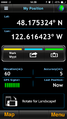
Coordinates reached.
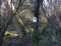
The sign is posted!
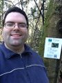
Mugshot time.


