Difference between revisions of "2014-01-26 50 8"
imported>Rincewind (→Achievements) |
imported>Rincewind (Added the photos, obviously.) |
||
| Line 1: | Line 1: | ||
| − | |||
| − | |||
| − | |||
| − | |||
| − | |||
| − | |||
| − | |||
| − | |||
| − | |||
{{meetup graticule | {{meetup graticule | ||
| lat=50 | | lat=50 | ||
| Line 33: | Line 24: | ||
We just had to go off the forest path for 10m or so at a spot without any underbrush or any other hindrance, so this one was fairly easy- the only real dirt was at the rather wet and muddy parking lot, actually. | We just had to go off the forest path for 10m or so at a spot without any underbrush or any other hindrance, so this one was fairly easy- the only real dirt was at the rather wet and muddy parking lot, actually. | ||
So we walked back to the car with a small detour and drove home with at least Rincewind's mind set on cake. | So we walked back to the car with a small detour and drove home with at least Rincewind's mind set on cake. | ||
| − | |||
| − | |||
| − | |||
== Photos == | == Photos == | ||
| − | |||
| − | |||
| − | |||
<gallery perrow="5"> | <gallery perrow="5"> | ||
| − | |||
Image:2014-01-26_50_8_16-17-36-915.jpg | Coordinates reached [http://www.openstreetmap.org/?lat=49.95563309&lon=8.60764870&zoom=16&layers=B000FTF @49.9556,8.6076] | Image:2014-01-26_50_8_16-17-36-915.jpg | Coordinates reached [http://www.openstreetmap.org/?lat=49.95563309&lon=8.60764870&zoom=16&layers=B000FTF @49.9556,8.6076] | ||
| + | Image:2014-01-26 50 8 parking.jpg| Parking lot and an uninviting, yet open-gated, fence. | ||
| + | Image:2014-01-26 50 8 barbecue.jpg| Quite nice and spacious, for a public barbecue spot. | ||
| + | Image:2014-01-26 50 8 forest.jpg| Nice area, the weather was nicer than the light indicates. | ||
| + | Image:2014-01-26 50 8 dancing.jpg| Yakamoz trying to get closer with the hashdroid | ||
| + | Image:2014-01-26 50 8 gpsproof.jpg| And another screenshot | ||
| + | Image:2014-01-26 50 8 hashgrin.jpg| Successful hashers | ||
</gallery> | </gallery> | ||
Revision as of 19:34, 26 January 2014
| Sun 26 Jan 2014 in 50,8: 50.0104337, 8.5536921 geohashing.info google osm bing/os kml crox |
Location
In the forest of (Mörfelden-)Walldorf, about a kilometer east of Startbahn West (starting runway 18 West)- will it be accessible?
Participants
Plans
This spot wasn't that far away, but yesterday we had abandoned the idea since it was quite close to the airport and we didn't know whether it was accessible- today, we spontaneously decided to go and have a try.
Expedition
We let the car navigation system guide us into the nearest street and kept a lookout for a good spot to park the car when nearing the coordinates. Our hopes fell a bit when we saw the forest was completely fenced in. I almost reckoned it would be airport grounds already, or a safety zone or something like that. Still, when we parked at a public barbecue spot, we found the gates open and strollers quite welcome. So we had a nice walk in the fair weather for some hundred meters (initial distance from the gate was 600m) and followed the forest ways to the hash, rather than fighting our way through the brush. We just had to go off the forest path for 10m or so at a spot without any underbrush or any other hindrance, so this one was fairly easy- the only real dirt was at the rather wet and muddy parking lot, actually. So we walked back to the car with a small detour and drove home with at least Rincewind's mind set on cake.
Photos

Coordinates reached @49.9556,8.6076
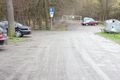
Parking lot and an uninviting, yet open-gated, fence.
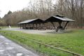
Quite nice and spacious, for a public barbecue spot.

Nice area, the weather was nicer than the light indicates.

Yakamoz trying to get closer with the hashdroid
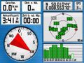
And another screenshot

Successful hashers


Achievements
Well, Land. Not worth all the editing trouble. :P