Difference between revisions of "2014-02-05 56 -2"
From Geohashing
imported>Wasindear (→Photos) |
imported>Squibakou |
||
| Line 24: | Line 24: | ||
<!-- who attended: If you link to your wiki user name in this section, your expedition will be picked up by the various statistics generated for geohashing. You may use three tildes ~ as a shortcut to automatically insert the user signature of the account you are editing with. | <!-- who attended: If you link to your wiki user name in this section, your expedition will be picked up by the various statistics generated for geohashing. You may use three tildes ~ as a shortcut to automatically insert the user signature of the account you are editing with. | ||
--> | --> | ||
| − | [[User:Wasindear|Wasindear]] | + | *[[User:Wasindear|Wasindear]] |
| + | *[[User:Squibakou|Squibakou]] | ||
== Plans == | == Plans == | ||
<!-- what were the original plans --> | <!-- what were the original plans --> | ||
| − | + | [[User:Squibakou|Squibakou]] and [[User:Wasindear|Wasindear]] planned to go to the hashpoint after our classes, cycling from the area known as the North Haugh out to the hashpoint. | |
== Expedition == | == Expedition == | ||
<!-- how it all turned out. your narrative goes here. --> | <!-- how it all turned out. your narrative goes here. --> | ||
| − | As planned we set out at about 4:30pm under less than desirable conditions. It took about 15 minutes to reach the location at which time the rain abated for long enough to get some pictures. We then cycled back into town, with only a minor set back when we both hit a pothole and | + | As planned we set out at about 4:30pm under less than desirable conditions. It took about 15 minutes to reach the location at which time the rain abated for long enough to get some pictures. We then cycled back into town, with only a minor set back when we both hit a pothole and [[User:Squibakou|Squibakou]] bike chain came off. |
== Photos == | == Photos == | ||
Revision as of 13:12, 8 February 2014
| Wed 5 Feb 2014 in 56,-2: 56.3355068, -2.8279398 geohashing.info google osm bing/os kml crox |
Location
The hashpoint was on the border between a garden and a field.
Participants
Plans
Squibakou and Wasindear planned to go to the hashpoint after our classes, cycling from the area known as the North Haugh out to the hashpoint.
Expedition
As planned we set out at about 4:30pm under less than desirable conditions. It took about 15 minutes to reach the location at which time the rain abated for long enough to get some pictures. We then cycled back into town, with only a minor set back when we both hit a pothole and Squibakou bike chain came off.
Photos
Squibakou almost falls

Squibakou hiding from rain

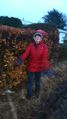
Wasindear looking a bit crazy
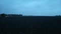
The field looking field-ish
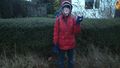
PEACE!

Togepi seems to have enjoyed the trip
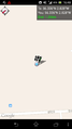
Confirmation screenshot


Achievements