Difference between revisions of "2014-02-12 44 -123"
From Geohashing
imported>Frogman (Created page with "{{subst:Expedition |lat = 44 |lon = -123 |date = 2014-02-12 }}") |
imported>FippeBot m (Location) |
||
| (6 intermediate revisions by one other user not shown) | |||
| Line 18: | Line 18: | ||
__NOTOC__ | __NOTOC__ | ||
== Location == | == Location == | ||
| − | + | A game management area north of Corvallis, Oregon. | |
== Participants == | == Participants == | ||
<!-- who attended: If you link to your wiki user name in this section, your expedition will be picked up by the various statistics generated for geohashing. You may use three tildes ~ as a shortcut to automatically insert the user signature of the account you are editing with. | <!-- who attended: If you link to your wiki user name in this section, your expedition will be picked up by the various statistics generated for geohashing. You may use three tildes ~ as a shortcut to automatically insert the user signature of the account you are editing with. | ||
--> | --> | ||
| + | *[[User:Frogman|Frogman]] | ||
| + | *[[User:AlecS|AlecS]] | ||
| + | *Greg | ||
== Plans == | == Plans == | ||
<!-- what were the original plans --> | <!-- what were the original plans --> | ||
| + | We planned on seeing if this was doable if the weather was nice. | ||
== Expedition == | == Expedition == | ||
<!-- how it all turned out. your narrative goes here. --> | <!-- how it all turned out. your narrative goes here. --> | ||
| + | It stopped raining around when we were all available at 5, so we left by car to the north. The hashpoint itself was in a state-run game reserve, but we had to go along a gravel boundary road to access it. The plants were wet from the rain and once we got into the forest there was still snow on the ground from last weekend's snow storm. It was dark at this point so we snapped a few photos of the hashpoint area and left. | ||
== Tracklog == | == Tracklog == | ||
| Line 38: | Line 43: | ||
--> | --> | ||
<gallery perrow="5"> | <gallery perrow="5"> | ||
| + | Image:2014-02-12_44_-123_grins.jpg | Grins! | ||
| + | Image:2014-02-12 44 -123 proof.jpg | Proof! | ||
| + | Image:2014-02-12 44 -123 scenery.jpg | Scenery! | ||
</gallery> | </gallery> | ||
| Line 45: | Line 53: | ||
| − | |||
| − | |||
| − | |||
| − | |||
| − | |||
| − | |||
| − | |||
| − | |||
| − | |||
| − | |||
[[Category:Expeditions]] | [[Category:Expeditions]] | ||
| − | |||
[[Category:Expeditions with photos]] | [[Category:Expeditions with photos]] | ||
| − | |||
| − | |||
| − | |||
| − | |||
| − | |||
[[Category:Coordinates reached]] | [[Category:Coordinates reached]] | ||
| − | + | {{location|US|OR|BE}} | |
| − | |||
| − | |||
| − | |||
| − | |||
| − | |||
| − | |||
| − | |||
| − | |||
| − | |||
| − | |||
| − | |||
| − | |||
| − | |||
| − | |||
| − | |||
| − | |||
| − | |||
Latest revision as of 05:30, 14 August 2019
| Wed 12 Feb 2014 in 44,-123: 44.6691348, -123.2885024 geohashing.info google osm bing/os kml crox |
Location
A game management area north of Corvallis, Oregon.
Participants
Plans
We planned on seeing if this was doable if the weather was nice.
Expedition
It stopped raining around when we were all available at 5, so we left by car to the north. The hashpoint itself was in a state-run game reserve, but we had to go along a gravel boundary road to access it. The plants were wet from the rain and once we got into the forest there was still snow on the ground from last weekend's snow storm. It was dark at this point so we snapped a few photos of the hashpoint area and left.
Tracklog
Photos

Grins!
Proof!
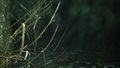
Scenery!


