Difference between revisions of "2014-02-16 49 8"
imported>Yakamoz (Coordinates reached) |
imported>FippeBot m (Location) |
||
| (4 intermediate revisions by 3 users not shown) | |||
| Line 1: | Line 1: | ||
| − | |||
| − | |||
| − | |||
| − | |||
| − | |||
| − | |||
| − | |||
| − | |||
| − | |||
| − | |||
{{meetup graticule | {{meetup graticule | ||
| lat=49 | | lat=49 | ||
| Line 18: | Line 8: | ||
__NOTOC__ | __NOTOC__ | ||
== Location == | == Location == | ||
| − | + | In the forest between Darmstadt and Roßdorf, next to the "Fischerhütte" club home and the five fishing ponds. | |
== Participants == | == Participants == | ||
| − | + | [[User:Yakamoz|Yakamoz]] and [[User:Rincewind|Rincewind]] | |
| − | |||
== Plans == | == Plans == | ||
| − | + | Drive to the club home and walk over to the hash. | |
| − | == Expedition == | + | == Expedition == |
| − | + | We didn't find the definitive, official road to the club home and rather than going semi-official or outright illegaly over some forest roads, we simply parked some two kilometers off target and took a leisurely stroll towards the hash. This wasn't that hard a decision to make, since we had time and the weather was rather beautiful. | |
| + | We had a large-area hash dance, and while accuracy wasn't that bad according to the satnav's display, the coordinates kept jumping wildly. I had "1m" for a split second, but couldn't even hit the screenshot button that fast. | ||
| + | Still, with 2m distance to the target, no obstacles in sight and a good 15m radius around the target having been "danced" on, this is a rather safe bet on "target reached". Next to the target there was some animal's scratching tree. Since I don't know that many animals with that habit in German forests, I am somehow hoping it might be a lynx, but who knows. It might be just Fischerhütte's resident cat, even though it'd have to be a rather tall one. | ||
| − | + | We took a small break on a bank next to one of the ponds to enjoy the sun for some minutes and then walked back to the car. 50m before we arrived, it started to drizzle and after we drove for some minutes, it rained rather heavily, so this time, we really had that timing right. | |
| − | + | Yay for geo hashing! | |
| − | == Photos == | + | == Photos == |
| − | |||
| − | |||
| − | |||
<gallery perrow="5"> | <gallery perrow="5"> | ||
| + | Image:2014-02-16 49 8 fischerhuette.jpg | Scenic Fischerhütte as seen on the approach. The coordinates are off to the right. | ||
| + | Image:2014-02-16 49 8 hashdance.jpg | Yakamoz trying to find the coordinates, as well. | ||
Image:2014-02-16_49_8_15-25-35-240.jpg | Coordinates reached | Image:2014-02-16_49_8_15-25-35-240.jpg | Coordinates reached | ||
| + | Image:2014-02-16 49 8 hashproof.jpg | The outdoor satnav thinks so, too. | ||
| + | Image:2014-02-16 49 8 hashspot.jpg | I decided that this mouldy tree spot is at the hash coordinates. About. | ||
| + | Image:2014-02-16 49 8 hashgrin.jpg | Happy hashers. | ||
</gallery> | </gallery> | ||
| Line 45: | Line 38: | ||
{{#vardefine:ribbonwidth|800px}} | {{#vardefine:ribbonwidth|800px}} | ||
<!-- Add any achievement ribbons you earned below, or remove this section --> | <!-- Add any achievement ribbons you earned below, or remove this section --> | ||
| + | Land. | ||
| − | |||
| − | |||
| − | |||
| − | |||
| − | |||
| − | |||
| − | |||
| − | |||
| − | |||
| − | |||
| − | |||
[[Category:Expeditions]] | [[Category:Expeditions]] | ||
| − | |||
[[Category:Expeditions with photos]] | [[Category:Expeditions with photos]] | ||
| − | |||
| − | |||
| − | |||
| − | |||
| − | |||
[[Category:Coordinates reached]] | [[Category:Coordinates reached]] | ||
| − | + | {{location|DE|HE|DA|city=true}} | |
| − | |||
| − | |||
| − | |||
| − | |||
| − | |||
| − | |||
| − | |||
| − | |||
| − | |||
| − | |||
| − | |||
| − | |||
| − | |||
| − | |||
| − | |||
| − | |||
| − | |||
Latest revision as of 05:32, 14 August 2019
| Sun 16 Feb 2014 in 49,8: 49.8541632, 8.7018647 geohashing.info google osm bing/os kml crox |
Location
In the forest between Darmstadt and Roßdorf, next to the "Fischerhütte" club home and the five fishing ponds.
Participants
Plans
Drive to the club home and walk over to the hash.
Expedition
We didn't find the definitive, official road to the club home and rather than going semi-official or outright illegaly over some forest roads, we simply parked some two kilometers off target and took a leisurely stroll towards the hash. This wasn't that hard a decision to make, since we had time and the weather was rather beautiful. We had a large-area hash dance, and while accuracy wasn't that bad according to the satnav's display, the coordinates kept jumping wildly. I had "1m" for a split second, but couldn't even hit the screenshot button that fast. Still, with 2m distance to the target, no obstacles in sight and a good 15m radius around the target having been "danced" on, this is a rather safe bet on "target reached". Next to the target there was some animal's scratching tree. Since I don't know that many animals with that habit in German forests, I am somehow hoping it might be a lynx, but who knows. It might be just Fischerhütte's resident cat, even though it'd have to be a rather tall one.
We took a small break on a bank next to one of the ponds to enjoy the sun for some minutes and then walked back to the car. 50m before we arrived, it started to drizzle and after we drove for some minutes, it rained rather heavily, so this time, we really had that timing right. Yay for geo hashing!
Photos
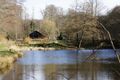
Scenic Fischerhütte as seen on the approach. The coordinates are off to the right.

Yakamoz trying to find the coordinates, as well.

Coordinates reached
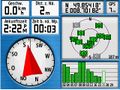
The outdoor satnav thinks so, too.

I decided that this mouldy tree spot is at the hash coordinates. About.

Happy hashers.


Achievements
Land.