Difference between revisions of "2014-02-15 43 -117"
imported>Eldin (initial page creation) |
imported>Eldin (add pictures and update categories) |
||
| Line 1: | Line 1: | ||
| − | |||
| − | |||
| − | |||
| − | |||
| − | |||
| − | |||
| − | |||
| − | |||
| − | |||
| − | |||
{{meetup graticule | {{meetup graticule | ||
| lat=43 | | lat=43 | ||
| Line 15: | Line 5: | ||
}} | }} | ||
| − | |||
__NOTOC__ | __NOTOC__ | ||
| Line 50: | Line 39: | ||
== Photos == | == Photos == | ||
| − | |||
| − | |||
| − | |||
<gallery perrow="5"> | <gallery perrow="5"> | ||
| + | File:2014-02-15 43 -117 proof.png | Proof of reaching coordinates. | ||
| + | File:2014-02-15 43 -116 grin.jpg | Grinning about reaching the hash, despite circumstances. | ||
</gallery> | </gallery> | ||
== Achievements == | == Achievements == | ||
{{#vardefine:ribbonwidth|800px}} | {{#vardefine:ribbonwidth|800px}} | ||
| − | |||
| − | + | {{Land geohash|latitude=43|longitude=-117|date=2014-02-15|name=[[User:Eldin|Eldin]]}} | |
| − | + | {{Minesweeper geohash | graticule = Boise, Idaho | ranknumber = 6 |nw = true| n = true | e = true | se = true | ne = true | w = true | name = [[User:Eldin|Eldin]]}} | |
| − | [[ | ||
| − | |||
| − | |||
| − | |||
| − | |||
| − | |||
[[Category:Expeditions]] | [[Category:Expeditions]] | ||
| − | |||
[[Category:Expeditions with photos]] | [[Category:Expeditions with photos]] | ||
| − | |||
| − | |||
| − | |||
| − | |||
| − | |||
[[Category:Coordinates reached]] | [[Category:Coordinates reached]] | ||
| − | |||
| − | |||
| − | |||
| − | |||
| − | |||
| − | |||
| − | |||
| − | |||
| − | |||
| − | |||
| − | |||
| − | |||
| − | |||
| − | |||
| − | |||
| − | |||
| − | |||
| − | |||
Revision as of 06:21, 21 February 2014
| Sat 15 Feb 2014 in 43,-117: 43.0803886, -117.0935817 geohashing.info google osm bing/os kml crox |
Location
In the desert a couple of miles off US-95, north of Jordan Valley, OR
Participants
Expedition
Originally, I wasn't going to try for this hash due to distance. But then that evening, our local Ingress community needed someone to go down to Jordan Valley to take down a big field. Seeing an opportunity to kill 2 birds with 1 stone, I volunteered. I figured I could go hit the hashpoint, and then still make it down to Jordan Valley before the midnight checkpoint.
I was wrong.
It had been raining a lot recently. After I pulled off the highway to head towards the hashpoint, I noticed that the dirt road I was on was a bit muddy. But it wasn't too bad, so I didn't worry much about it. But as I went on and took turns, the road got increasingly primitive. But despite the mud, my car seemed to be handling things ok. Until I hit a patch of road that had turned mostly liquid, that is.
About 300ft short of where I had intended to pull off to head for the hashpoint, the left side of my car sunk in the mud. It sunk deep enough that the car body was resting almost an inch below the surface of the mud. My forward progress stopped. I tried to back up, but was unable to do so. I was stuck. I was also only 560m from the hash.
There was no way I was going to let a little thing like a stuck car, in the middle of nowhere, miles from anywhere with a mobile phone signal, at almost 11pm, deter me from reaching the hash after coming that far.
So I left the car, and set out walking through the mud towards the hashpoint. I had my phone and my camera, but forgot to grab the flashlight from the car. By the time I thought of the flashlight, I didn't want to wade back through the mud an extra two times to get it. So I walked half a kilometer through the mud, in the dark. I tore my pants crossing a barbed wire fence (I looked for no trespassing signs, but found none). But I reached the hash.
Then I headed back to the car. There was no way the car was getting out of there under its own power. Normally, they say to stay with the car when you're stuck or broken down. But out here, it could be days before anyone came by. So I set out walking. I walked about 2 miles on muddy roads to get back to the highway, which took a bit over an hour. This put it past midnight. I tried to flag down a van that was passing as I reached the highway, but they didn't stop. So I started walking, towards Jordan Valley (about 10 miles away). I tried to flag down every vehicle that passed. A car passed, but they didn't stop. A semi passed. They pulled to the opposite side of the road while they passed, but didn't stop. Finally, after I'd walked nearly 2 miles, a truck going the other way stopped. First, he offered to let me use his phone to call for help. But after he realized he didn't have a signal, he agreed to give me ride the 40 miles or so back to Marsing (the nearest place with a mobile phone signal). So by 1:15am, I was able to call and let my wife know I was ok, and call someone to give me a ride from the gas station in Marsing where I was dropped off.
Fortunately, I was able to get my dad and my uncle down there with a couple of trucks the next day, and we got my car out of the mud.
Unfortunately, we were pressed for time because it was snowing (and the snow was starting to turn to rain) while we were doing so, so I didn't manage to get any pictures of the stuck car.
And I did eventually make it to Jordan Valley, to take out that portal. Only 14 hours later than originally intended.
Photos
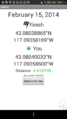
Proof of reaching coordinates.

Grinning about reaching the hash, despite circumstances.


Achievements
Eldin earned the Land geohash achievement
|
Eldin achieved level 6 of the Minesweeper Geohash achievement
|