Difference between revisions of "2014-03-01 48 16"
From Geohashing
imported>Micsnare (→Tracklog) |
imported>Micsnare (→Achievements) |
||
| Line 53: | Line 53: | ||
{{#vardefine:ribbonwidth|800px}} | {{#vardefine:ribbonwidth|800px}} | ||
<!-- Add any achievement ribbons you earned below, or remove this section --> | <!-- Add any achievement ribbons you earned below, or remove this section --> | ||
| + | |||
| + | {{land geohash | ||
| + | | latitude = 48 | ||
| + | | longitude = 15 | ||
| + | | date = 2014-03-01 | ||
| + | }} | ||
| + | {{Multihash2 | ||
| + | | name = micsnare | ||
| + | | count = 2 | ||
| + | | date = 2014-03-01 | ||
| + | }} | ||
| + | |||
| + | [[Category:Expedition planning]] | ||
| + | [[Category:Expeditions]] | ||
| + | [[Category:Expeditions with photos]] | ||
| + | [[Category:Coordinates reached]] | ||
| + | [[Category: Meetup on 2014-08-30]] | ||
| + | [[Category: Meetup in 48 16]] | ||
[[Category:Expedition planning]] | [[Category:Expedition planning]] | ||
Revision as of 19:28, 3 September 2014
| Sat 1 Mar 2014 in 48,16: 48.2267331, 16.8631407 geohashing.info google osm bing/os kml crox |
Location
In Breitenlee, near the viennese and lower-austrian border
Participants
Plans
Expedition
- Wien Hash 2014-03-01 mit Theresa, yay! -- B2c (talk) @48.2267,16.8631 18:15, 1 March 2014 (CET)
Tracklog

Photos
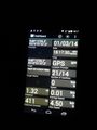
documenting the hash with our GPS coordinates..

B2c posing in front of the camera ;-)
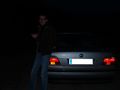
showing how dark it was during our first hash
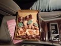
THEM cookies....every hasher needs their cookies and soft drinks ;-)


Achievements
This user earned the Land geohash achievement
|
micsnare earned the Multihash Achievement
|