Difference between revisions of "2014-03-01 48 16"
imported>B2c ([live] Wien Hash 2014-03-01 mit Theresa, yay!) |
imported>FippeBot m (Location) |
||
| (15 intermediate revisions by 5 users not shown) | |||
| Line 19: | Line 19: | ||
== Location == | == Location == | ||
<!-- where you've surveyed the hash to be --> | <!-- where you've surveyed the hash to be --> | ||
| + | In Lassee, in Lower-Austrian near the Hungarian border | ||
== Participants == | == Participants == | ||
<!-- who attended: If you link to your wiki user name in this section, your expedition will be picked up by the various statistics generated for geohashing. You may use three tildes ~ as a shortcut to automatically insert the user signature of the account you are editing with. | <!-- who attended: If you link to your wiki user name in this section, your expedition will be picked up by the various statistics generated for geohashing. You may use three tildes ~ as a shortcut to automatically insert the user signature of the account you are editing with. | ||
--> | --> | ||
| + | * [[User:micsnare|micsnare]] | ||
| + | * [[User:B2c|B2c]] | ||
| − | == | + | == Planing == |
<!-- what were the original plans --> | <!-- what were the original plans --> | ||
| + | |||
| + | B2c did all the planning, kudos to him, we hardly got lost on our way to our hashpoints ;-) | ||
== Expedition == | == Expedition == | ||
<!-- how it all turned out. your narrative goes here. --> | <!-- how it all turned out. your narrative goes here. --> | ||
| + | B2c picked me up with his car at subway station Landstraße/Wien Mitte, that's where we met at 5pm. I was already excited since I had never done any geo hashing before. On the way to the first hashpoint which was in the Vienna graticule, he told me all the fuzz about geohashing and not to confuse it with Geocaching. He also told me about the many achievements that you can receive when you've successfully found your hashpoint and I got the feeling that he wanted to impress me with his latest achievements, e.g the time-traveller achievement ;-) (it worked, but more of later on...) | ||
| + | |||
| + | Anyway, when we finally arrived at our first hashpoint in Lassee, which honestly speaking was in the middle-of-nowhere, we had to walk through a field to reach the exact position. Since was still winter (March 1st) it was getting dark early around 6pm, so we only took a few dark/blurry photos and hopped back into our car. Before we left we had a bit of a picnic with delicious cookies and soft drinks that B2c brought along. nom nom nom ;-) | ||
| + | |||
| + | Lassee, I have to say, you left me awestruck with being my very first hashpoint, I will never forget! | ||
*Wien Hash 2014-03-01 mit Theresa, yay! -- [[User:B2c|B2c]] ([[User talk:B2c|talk]]) [http://www.openstreetmap.org/?lat=48.22674867&lon=16.86313805&zoom=16&layers=B000FTF @48.2267,16.8631] 18:15, 1 March 2014 (CET) | *Wien Hash 2014-03-01 mit Theresa, yay! -- [[User:B2c|B2c]] ([[User talk:B2c|talk]]) [http://www.openstreetmap.org/?lat=48.22674867&lon=16.86313805&zoom=16&layers=B000FTF @48.2267,16.8631] 18:15, 1 March 2014 (CET) | ||
| + | |||
== Tracklog == | == Tracklog == | ||
<!-- if your GPS device keeps a log, you may post a link here --> | <!-- if your GPS device keeps a log, you may post a link here --> | ||
| + | [[Image:2014-03-01_Tracklog.png| |Tracklog of the operation.]] | ||
== Photos == | == Photos == | ||
| Line 40: | Line 52: | ||
--> | --> | ||
<gallery perrow="5"> | <gallery perrow="5"> | ||
| + | Image:2014-03-01_Breitenlee.jpg | documenting the hash with our GPS coordinates.. | ||
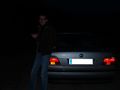
| + | Image:01-03-2014-Breitenlee3.jpg | B2c standing in front of our hashcot ;-) | ||
| + | Image:01-03-2014-Breitenlee4.jpg | showing how dark it was during our first hash | ||
| + | Image:2013-03-01_cookies.jpg | THEM cookies....every hasher needs their cookies and soft drinks ;-) | ||
</gallery> | </gallery> | ||
| Line 46: | Line 62: | ||
<!-- Add any achievement ribbons you earned below, or remove this section --> | <!-- Add any achievement ribbons you earned below, or remove this section --> | ||
| + | {{land geohash | ||
| + | | latitude = 48 | ||
| + | | longitude = 15 | ||
| + | | date = 2014-03-01 | ||
| + | }} | ||
| + | {{Multihash2 | ||
| + | | name = micsnare | ||
| + | | count = 2 | ||
| + | | date = 2014-03-01 | ||
| + | }} | ||
| − | |||
| − | |||
| − | |||
| − | |||
| − | |||
| − | |||
| − | |||
| − | |||
| − | |||
| − | |||
| − | |||
[[Category:Expeditions]] | [[Category:Expeditions]] | ||
| − | |||
[[Category:Expeditions with photos]] | [[Category:Expeditions with photos]] | ||
| − | |||
| − | |||
| − | |||
| − | |||
| − | |||
[[Category:Coordinates reached]] | [[Category:Coordinates reached]] | ||
| − | + | {{location|AT|NÖ|GF}} | |
| − | |||
| − | |||
| − | |||
| − | |||
| − | |||
| − | |||
| − | |||
| − | |||
| − | |||
| − | |||
| − | |||
| − | |||
| − | |||
| − | |||
| − | |||
| − | |||
| − | |||
Latest revision as of 05:43, 14 August 2019
| Sat 1 Mar 2014 in 48,16: 48.2267331, 16.8631407 geohashing.info google osm bing/os kml crox |
Location
In Lassee, in Lower-Austrian near the Hungarian border
Participants
Planing
B2c did all the planning, kudos to him, we hardly got lost on our way to our hashpoints ;-)
Expedition
B2c picked me up with his car at subway station Landstraße/Wien Mitte, that's where we met at 5pm. I was already excited since I had never done any geo hashing before. On the way to the first hashpoint which was in the Vienna graticule, he told me all the fuzz about geohashing and not to confuse it with Geocaching. He also told me about the many achievements that you can receive when you've successfully found your hashpoint and I got the feeling that he wanted to impress me with his latest achievements, e.g the time-traveller achievement ;-) (it worked, but more of later on...)
Anyway, when we finally arrived at our first hashpoint in Lassee, which honestly speaking was in the middle-of-nowhere, we had to walk through a field to reach the exact position. Since was still winter (March 1st) it was getting dark early around 6pm, so we only took a few dark/blurry photos and hopped back into our car. Before we left we had a bit of a picnic with delicious cookies and soft drinks that B2c brought along. nom nom nom ;-)
Lassee, I have to say, you left me awestruck with being my very first hashpoint, I will never forget!
- Wien Hash 2014-03-01 mit Theresa, yay! -- B2c (talk) @48.2267,16.8631 18:15, 1 March 2014 (CET)
Tracklog

Photos
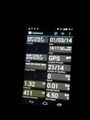
documenting the hash with our GPS coordinates..

B2c standing in front of our hashcot ;-)
showing how dark it was during our first hash
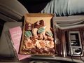
THEM cookies....every hasher needs their cookies and soft drinks ;-)


Achievements
This user earned the Land geohash achievement
|
micsnare earned the Multihash Achievement
|