Difference between revisions of "2013-02-02 31 -3"
From Geohashing
imported>TFTD (Content) |
imported>GeorgDerReisende |
||
| Line 1: | Line 1: | ||
| − | |||
| − | |||
| − | |||
| − | |||
| − | |||
| − | |||
| − | |||
| − | |||
| − | |||
| − | |||
{{meetup graticule | {{meetup graticule | ||
| lat=31 | | lat=31 | ||
| Line 49: | Line 39: | ||
| − | |||
[[Category:Expeditions]] | [[Category:Expeditions]] | ||
[[Category:Expeditions with photos]] | [[Category:Expeditions with photos]] | ||
| − | |||
[[Category:Coordinates not reached]] | [[Category:Coordinates not reached]] | ||
[[Category:Not reached - Did not attempt]] | [[Category:Not reached - Did not attempt]] | ||
| + | |||
| + | [[Category:Needs attention]] | ||
Revision as of 23:08, 15 November 2014
| Sat 2 Feb 2013 in 31,-3: 31.2335908, -3.9685229 geohashing.info google osm bing/os kml crox |
Location
At the edge of the Sahara dessert in the dunes.
Participants
TFTD and other people around me.
Plans
No plans back than, just realized today that I was really close by.
Expedition
Overall nice trip at the edge of the dessert, but that was not because of geohashing. Picture taken at roughly 31.20814,-3.981564. And I spend the night at 31.217463,-3.979075
Tracklog
Photos
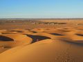
The red arrow approximately marks the location of the hash.
