Difference between revisions of "2014-03-22 34 -120"
From Geohashing
imported>S0meb0dy |
imported>Palmpje m |
||
| Line 56: | Line 56: | ||
<!-- Add any achievement ribbons you earned below, or remove this section --> | <!-- Add any achievement ribbons you earned below, or remove this section --> | ||
{{Virgin graticule|date=2014-03-22|latitude=34|longitude=-120|name=[[User:s0meb0dy|s0meb0dy]]}} | {{Virgin graticule|date=2014-03-22|latitude=34|longitude=-120|name=[[User:s0meb0dy|s0meb0dy]]}} | ||
| − | |||
| − | |||
[[Category:Expeditions]] | [[Category:Expeditions]] | ||
[[Category:Expeditions with photos]] | [[Category:Expeditions with photos]] | ||
[[Category:Coordinates reached]] | [[Category:Coordinates reached]] | ||
Revision as of 10:10, 23 March 2014
| Sat 22 Mar 2014 in 34,-120: 34.7440204, -120.2771792 geohashing.info google osm bing/os kml crox |
Location
Right on Bell St/Highway 135 on the shoulder in Los Alamos.
Participants
Plans
Expedition
Planned to set out and go to Chumash Casino but that didn't work out. I did make it in time for a 4pm meetup if there were others but I didn't hold out hope since this graticule gets less notice than Santa Barbara. Took some pics, posted a notice, marked the street with chalk for future historians, waited till about 4:15 and left. I did take a trip to the Los Alamos Cemetary were I have long ago relatives. Very peaceful.
- Success! -- S0meb0dy (talk) @34.7440,-120.2772 15:23, 22 March 2014 (PDT)
Tracklog
Photos
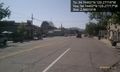
Up Highway 135 @34.7440,-120.2772
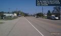
Down Highway 135 @34.7440,-120.2772
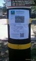
Posted message for future visitors. @34.7439,-120.2771
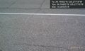
X marks the spot. @34.7440,-120.2772


