Difference between revisions of "2014-04-22 34 -118"
From Geohashing
imported>Bravissimo594 m ([live picture] Shady picnic area. [http://www.openstreetmap.org/?lat=34.14160000&lon=-118.18700000&zoom=16&layers=B000FTF @34.1416,-118.1870]) |
imported>FippeBot m (Location) |
||
| (5 intermediate revisions by one other user not shown) | |||
| Line 50: | Line 50: | ||
Image:2014-04-22_34_-118_Bravissimo594_1398202914932.jpg | Shady picnic area. [http://www.openstreetmap.org/?lat=34.14160000&lon=-118.18700000&zoom=16&layers=B000FTF @34.1416,-118.1870] | Image:2014-04-22_34_-118_Bravissimo594_1398202914932.jpg | Shady picnic area. [http://www.openstreetmap.org/?lat=34.14160000&lon=-118.18700000&zoom=16&layers=B000FTF @34.1416,-118.1870] | ||
| + | |||
| + | Image:2014-04-22_34_-118_Bravissimo594_1398202929204.jpg | Nearby pavillion for reservations only. [http://www.openstreetmap.org/?lat=34.14160000&lon=-118.18700000&zoom=16&layers=B000FTF @34.1416,-118.1870] | ||
| + | |||
| + | Image:2014-04-22_34_-118_Bravissimo594_1398203005395.jpg | Marked. [http://www.openstreetmap.org/?lat=34.14150000&lon=-118.18700000&zoom=16&layers=B000FTF @34.1415,-118.1870] | ||
| + | |||
| + | Image:2014-04-22_34_-118_Bravissimo594_1398202886413.jpg | Bravo! [http://www.openstreetmap.org/?lat=34.14160000&lon=-118.18700000&zoom=16&layers=B000FTF @34.1416,-118.1870] | ||
| + | |||
| + | Image:2014-04-22_34_-118_Bravissimo594_1398202900031.jpg | Boppy5 and me. [http://www.openstreetmap.org/?lat=34.14160000&lon=-118.18700000&zoom=16&layers=B000FTF @34.1416,-118.1870] | ||
</gallery> | </gallery> | ||
| Line 65: | Line 73: | ||
<!-- Potential categories. Please include all the ones appropriate to your expedition --> | <!-- Potential categories. Please include all the ones appropriate to your expedition --> | ||
<!-- If this is a planning page: --> | <!-- If this is a planning page: --> | ||
| − | |||
| − | <!-- An actual expedition: | + | <!-- An actual expedition: --> |
[[Category:Expeditions]] | [[Category:Expeditions]] | ||
| − | |||
[[Category:Expeditions with photos]] | [[Category:Expeditions with photos]] | ||
| − | |||
| − | |||
| − | |||
| − | <!-- if you reached your coords: | + | <!-- if you reached your coords: --> |
[[Category:Coordinates reached]] | [[Category:Coordinates reached]] | ||
| − | + | <!-- or if you failed :( | |
| − | |||
[[Category:Coordinates not reached]] | [[Category:Coordinates not reached]] | ||
-- and a reason -- | -- and a reason -- | ||
| Line 95: | Line 97: | ||
(Don't forget to delete this final close comment marker) --> | (Don't forget to delete this final close comment marker) --> | ||
| + | {{location|US|CA|LO}} | ||
Latest revision as of 06:16, 14 August 2019
| Have you seen our geohashing marker? We'd love to hear from you! Click here to say "hi" and tell us what you've seen!
Curious about what geohashing is? Read more! |  |
| Tue 22 Apr 2014 in 34,-118: 34.1416017, -118.1868985 geohashing.info google osm bing/os kml crox |
Location
- In a park in Eagle Rock. Los Angeles graticule.
- Eagle Rock Recreation Center
Participants
Plans
- I will decide later today what time to be there. I am flexible, so if anyone else has a more rigid schedule, propose a time; I will see if I can match it. -- Bravissimo594 (talk) 10:00, 22 April 2014 (EDT)
- It looks like it will be sometime between 2:30 and 3:00 pm. -- Bravissimo594 (talk) 12:25, 22 April 2014 (EDT)
Expedition
Tracklog
Photos

Geohash Droid details. Success! @34.1417,-118.1871

Shady picnic area. @34.1416,-118.1870
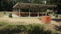
Nearby pavillion for reservations only. @34.1416,-118.1870
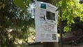
Marked. @34.1415,-118.1870
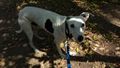
Bravo! @34.1416,-118.1870

Boppy5 and me. @34.1416,-118.1870


