Difference between revisions of "2014-04-30 51 9"
imported>GeorgDerReisende (new expedition to Calden) |
imported>FippeBot m (Location) |
||
| (2 intermediate revisions by one other user not shown) | |||
| Line 20: | Line 20: | ||
== Expedition == | == Expedition == | ||
| − | + | ||
| + | I took the trams 3 and 5 and then the bus 100 to the airport. I arrived there at 12:15. Then I started to walk, along the national road. The hash lay in a thicket about ten meters away from the forest way. So far as this sort of green can called a forest, because the raptors had been around. After a short dance I found the hash and did all usual deeds. | ||
| + | |||
| + | For the way back to Kassel I decided to hitchhike, but after a thunder I looked to the big clouds and I changed my mind and took the bus again. | ||
| + | |||
| + | At home I found out, that the hash is not in Calden but in Grebenstein. | ||
== Tracklog == | == Tracklog == | ||
| Line 26: | Line 31: | ||
== Photos == | == Photos == | ||
| − | |||
| − | |||
| − | |||
<gallery perrow="5"> | <gallery perrow="5"> | ||
| + | Image:2014-04-30 51 9 GeorgDerReisende 9711.jpg | walking along the national road | ||
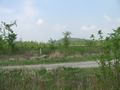
| + | Image:2014-04-30 51 9 GeorgDerReisende 9715.jpg | the hash lies in the thicket to the left | ||
| + | Image:2014-04-30 51 9 GeorgDerReisende 9718.jpg | proof 1 | ||
| + | Image:2014-04-30 51 9 GeorgDerReisende 9719.jpg | proof 2 | ||
| + | Image:2014-04-30 51 9 GeorgDerReisende 9721.jpg | GeorgDerReisende | ||
| + | Image:2014-04-30 51 9 GeorgDerReisende 9722.jpg | the north | ||
| + | Image:2014-04-30 51 9 GeorgDerReisende 9723.jpg | the west | ||
| + | Image:2014-04-30 51 9 GeorgDerReisende 9724.jpg | the east | ||
| + | Image:2014-04-30 51 9 GeorgDerReisende 9725.jpg | the south | ||
| + | Image:2014-04-30 51 9 GeorgDerReisende 9726.jpg | the hashmark | ||
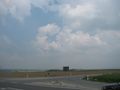
| + | Image:2014-04-30 51 9 GeorgDerReisende 9733.jpg | view to Calden | ||
| + | Image:2014-04-30 51 9 GeorgDerReisende 9734.jpg | a plane starting at the airport | ||
| + | Image:2014-04-30 51 9 GeorgDerReisende 9740.jpg | a lot of traffic | ||
| + | Image:2014-04-30 51 9 GeorgDerReisende 9748.jpg | clouds | ||
</gallery> | </gallery> | ||
| Line 36: | Line 52: | ||
<!-- Add any achievement ribbons you earned below, or remove this section --> | <!-- Add any achievement ribbons you earned below, or remove this section --> | ||
| + | {{Public transport geohash | latitude = 51 | longitude = 9 | date = 2014-04-30 | busline = trams 3 & 5, bus 100 | name = GeorgDerReisende }} | ||
| − | + | [[Category:Expeditions]] | |
| − | |||
| − | [[Category: | ||
| − | + | [[Category:Expeditions with photos]] | |
| − | |||
| − | |||
| − | |||
| − | [[Category: | ||
| − | |||
| − | |||
| − | |||
| − | |||
| − | |||
| − | |||
| − | |||
| − | |||
| − | |||
| − | |||
[[Category:Coordinates reached]] | [[Category:Coordinates reached]] | ||
| − | + | {{location|DE|HE|KS}} | |
| − | |||
| − | |||
| − | |||
| − | |||
| − | |||
| − | |||
| − | |||
| − | |||
| − | |||
| − | |||
| − | |||
| − | |||
| − | |||
| − | |||
| − | |||
| − | |||
| − | |||
Latest revision as of 06:22, 14 August 2019
| Wed 30 Apr 2014 in 51,9: 51.4201760, 9.3690883 geohashing.info google osm bing/os kml crox |
Location
The hash lies in a forest some meters west of the airport Kassel.
Participants
Plans
I want to take the bus 100 to the airport and walk to the hash.
Expedition
I took the trams 3 and 5 and then the bus 100 to the airport. I arrived there at 12:15. Then I started to walk, along the national road. The hash lay in a thicket about ten meters away from the forest way. So far as this sort of green can called a forest, because the raptors had been around. After a short dance I found the hash and did all usual deeds.
For the way back to Kassel I decided to hitchhike, but after a thunder I looked to the big clouds and I changed my mind and took the bus again.
At home I found out, that the hash is not in Calden but in Grebenstein.
Tracklog
Photos
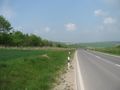
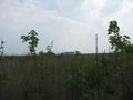
walking along the national road

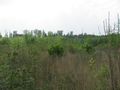
the hash lies in the thicket to the left
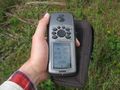
proof 1
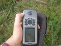
proof 2

GeorgDerReisende
the north
the west
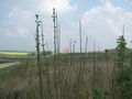
the east
the south
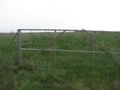
the hashmark

view to Calden
a plane starting at the airport
a lot of traffic
clouds


Achievements
GeorgDerReisende earned the Public transport geohash achievement
|