Difference between revisions of "2014-05-01 51 9"
imported>GeorgDerReisende (new expedition) |
imported>FippeBot m (Location) |
||
| (One intermediate revision by one other user not shown) | |||
| Line 1: | Line 1: | ||
| − | |||
| − | |||
| − | |||
| − | |||
| − | |||
| − | |||
| − | |||
| − | |||
| − | |||
| − | |||
{{meetup graticule | {{meetup graticule | ||
| lat=51 | | lat=51 | ||
| Line 18: | Line 8: | ||
__NOTOC__ | __NOTOC__ | ||
== Location == | == Location == | ||
| − | + | ||
| + | The hash lies beside a road in the forest Reinhardswald. | ||
== Participants == | == Participants == | ||
| − | + | ||
| − | + | [[User:GeorgDerReisende|GeorgDerReisende]] | |
== Plans == | == Plans == | ||
| − | + | ||
| + | Just a try: to go there by hitchhiking if possible. | ||
== Expedition == | == Expedition == | ||
| − | + | ||
| + | I started to hitchhike at the bypass of Ihringshausen at 11:45 and got a lift to Schocketal, where I got a second car, which brought me direct to the hash. I found the hash behind some small firs. After a short dance I found the exact spot. I took some photos. Then I walked to the Sababurg and the animal park there, then I returned. I walked along the street for about three kilometers, then I got a lift back to Kassel, where I arrived at 15:30. | ||
== Tracklog == | == Tracklog == | ||
| Line 34: | Line 27: | ||
== Photos == | == Photos == | ||
| − | |||
| − | |||
| − | |||
<gallery perrow="5"> | <gallery perrow="5"> | ||
| + | Image:2014-05-01 51 9 GeorgDerReisende 9763.jpg | the bypass of Ihringshausen | ||
| + | Image:2014-05-01 51 9 GeorgDerReisende 9766.jpg | the hash lies behind these trees | ||
| + | Image:2014-05-01 51 9 GeorgDerReisende 9767.jpg | a better view around the trees | ||
| + | Image:2014-05-01 51 9 GeorgDerReisende 9769.jpg | proof 1 | ||
| + | Image:2014-05-01 51 9 GeorgDerReisende 9770.jpg | proof 2 | ||
| + | Image:2014-05-01 51 9 GeorgDerReisende 9771.jpg | view to the north | ||
| + | Image:2014-05-01 51 9 GeorgDerReisende 9772.jpg | view to the west | ||
| + | Image:2014-05-01 51 9 GeorgDerReisende 9773.jpg | view to the south | ||
| + | Image:2014-05-01 51 9 GeorgDerReisende 9774.jpg | view to the east | ||
| + | Image:2014-05-01 51 9 GeorgDerReisende 9776.jpg | I wrote the mark onto the road | ||
| + | Image:2014-05-01 51 9 GeorgDerReisende 9778.jpg | the road to the north, downhill | ||
| + | Image:2014-05-01 51 9 GeorgDerReisende 9779.jpg | the road to the south, uphill | ||
| + | Image:2014-05-01 51 9 GeorgDerReisende 9781.jpg | the forest east of the road | ||
| + | Image:2014-05-01 51 9 GeorgDerReisende 9820.jpg | back in Kassel | ||
</gallery> | </gallery> | ||
| Line 44: | Line 48: | ||
<!-- Add any achievement ribbons you earned below, or remove this section --> | <!-- Add any achievement ribbons you earned below, or remove this section --> | ||
| + | {{Thumbs Up | latitude = 51 | longitude = 9 | date = 2014-05-01 | name = GeorgDerReisende }} | ||
| − | + | [[Category:Expeditions]] | |
| − | |||
| − | [[Category: | ||
| − | + | [[Category:Expeditions with photos]] | |
| − | |||
| − | |||
| − | |||
| − | [[Category: | ||
| − | |||
| − | |||
| − | |||
| − | |||
| − | |||
| − | |||
| − | |||
| − | |||
| − | |||
| − | |||
[[Category:Coordinates reached]] | [[Category:Coordinates reached]] | ||
| − | + | {{location|DE|HE|KS}} | |
| − | |||
| − | |||
| − | |||
| − | |||
| − | |||
| − | |||
| − | |||
| − | |||
| − | |||
| − | |||
| − | |||
| − | |||
| − | |||
| − | |||
| − | |||
| − | |||
| − | |||
Latest revision as of 06:24, 14 August 2019
| Thu 1 May 2014 in 51,9: 51.5439160, 9.5564726 geohashing.info google osm bing/os kml crox |
Location
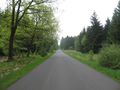
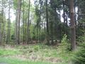
The hash lies beside a road in the forest Reinhardswald.
Participants
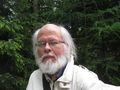
Plans
Just a try: to go there by hitchhiking if possible.
Expedition
I started to hitchhike at the bypass of Ihringshausen at 11:45 and got a lift to Schocketal, where I got a second car, which brought me direct to the hash. I found the hash behind some small firs. After a short dance I found the exact spot. I took some photos. Then I walked to the Sababurg and the animal park there, then I returned. I walked along the street for about three kilometers, then I got a lift back to Kassel, where I arrived at 15:30.
Tracklog
Photos
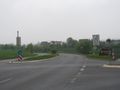
the bypass of Ihringshausen
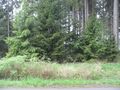
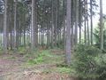
the hash lies behind these trees
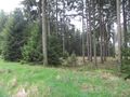
a better view around the trees
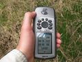
proof 1
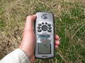
proof 2
view to the north
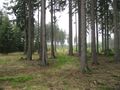
view to the west
view to the south
view to the east
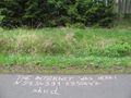
I wrote the mark onto the road
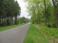
the road to the north, downhill
the road to the south, uphill
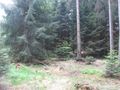
the forest east of the road
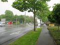
back in Kassel


Achievements
GeorgDerReisende earned the Thumbs Up Geohash Achievement
|