Difference between revisions of "2014-05-01 51 14"
imported>AmicaNoctis (→Photos) |
imported>AmicaNoctis (→Achievements) |
||
| Line 47: | Line 47: | ||
| − | |||
| − | |||
| − | |||
| − | |||
| − | |||
| − | |||
| − | |||
| − | |||
| − | |||
| − | |||
| − | |||
| − | |||
[[Category:Expeditions]] | [[Category:Expeditions]] | ||
| − | |||
[[Category:Expeditions with photos]] | [[Category:Expeditions with photos]] | ||
| − | |||
| − | |||
| − | |||
| − | |||
| − | |||
[[Category:Coordinates reached]] | [[Category:Coordinates reached]] | ||
| − | |||
| − | |||
| − | |||
| − | |||
| − | |||
| − | |||
| − | |||
| − | |||
| − | |||
| − | |||
| − | |||
| − | |||
| − | |||
| − | |||
| − | |||
| − | |||
| − | |||
| − | |||
Revision as of 18:37, 1 May 2014
| Thu 1 May 2014 in 51,14: 51.5439160, 14.5564726 geohashing.info google osm bing/os kml crox |
Location
near Halbendorfer See, Schleife (near Weißwasser), Saxony, Germany
Participants
Plans
As a first time Geohasher I just wanted to visit the spot while at the same time trying my til-then virgin panoramic tripod head.
Expedition
We went 65km by car to the location and tried to be there around 4pm to maximize the chance to meet someone there. We dropped the car besides the road and walked the last few meters to the location. At first, we took the mandatory selfie, then we went on erecting and levelling the tripod for the panorama shooting. After taking 4 horizontal picture rows, each having 48 HDR brackets of 3 shots each, it suddenly was an hour later and we recognized that no one would come here around the conventional meetup time. We packed our things together and visited the nearby lake "Halbendorfer See", where some guys in wetsuits were riding wakeboards pulled by a motor-driven cable system, which had been opened just around Easter this year -- quite something to come back for another time! On the way home we stopped in a restaurant in Weißwasser for dinner and then arrived at home just before the rain set in.
Photos
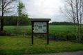
Information sign near the geohash location.
