Difference between revisions of "2014-05-21 50 13"
imported>Ravise (init) |
imported>FippeBot m (Location) |
||
| (2 intermediate revisions by one other user not shown) | |||
| Line 4: | Line 4: | ||
[[Image:{{{image|IMAGE}}}|thumb|left]] | [[Image:{{{image|IMAGE}}}|thumb|left]] | ||
| − | |||
| − | |||
| − | |||
| − | |||
--> | --> | ||
{{meetup graticule | {{meetup graticule | ||
| Line 15: | Line 11: | ||
}} | }} | ||
| − | |||
__NOTOC__ | __NOTOC__ | ||
== Location == | == Location == | ||
| − | + | In a field few steps road near Vršovice | |
== Participants == | == Participants == | ||
| − | + | [[User:Ravise|Ravise]] | |
| − | |||
== Plans == | == Plans == | ||
| − | + | Ravise is probably going to get there by bike, time unknown yet. | |
== Expedition == | == Expedition == | ||
| − | + | I've left at 1PM. Terrible weather for expedition. Too hot to cycle. Nevermind. Looooong boooring journey. Few angry truck drivers. | |
| + | |||
| + | I've got near to hashpoint at about 3:30PM. Too hot to wait. I did the ordinary stuff and left quickly, in order not to run out of water. | ||
| + | |||
| + | On my way back to Most something happened to one of the pedal, which finally totaly broke in Most. Yet it way three kilometers to go, so I called my dad to pick me up, because the bike was unusable. | ||
| − | + | I got sunburned, but nevermind, it was Geohashing day expedition! :) | |
| − | |||
== Photos == | == Photos == | ||
| − | |||
| − | |||
| − | |||
<gallery perrow="5"> | <gallery perrow="5"> | ||
| + | File:2014-05-21_50_13_hash.jpeg | Hashpoint unreachable due to water. Yet close enough. | ||
| + | File:2014-05-21_50_13_toast.jpeg| Toast. For all brave geohashers. | ||
| + | File:2014-05-21_50_13_bike.jpeg | My poor disassambled bike. | ||
</gallery> | </gallery> | ||
| + | |||
== Achievements == | == Achievements == | ||
{{#vardefine:ribbonwidth|800px}} | {{#vardefine:ribbonwidth|800px}} | ||
| − | |||
| + | {{Geohashing Day | ||
| − | + | | latitude = 50 | |
| − | + | | longitude = 13 | |
| − | + | | year = 2014 | |
| + | | coorddate= 2014-05-21 | ||
| + | | name = Ravise | ||
| + | |||
| + | }} | ||
| − | |||
| − | |||
| − | |||
| − | |||
| − | |||
| − | |||
| − | |||
[[Category:Expeditions]] | [[Category:Expeditions]] | ||
| − | |||
[[Category:Expeditions with photos]] | [[Category:Expeditions with photos]] | ||
| − | |||
[[Category:Expedition without GPS]] | [[Category:Expedition without GPS]] | ||
| − | |||
| − | |||
| − | |||
[[Category:Coordinates reached]] | [[Category:Coordinates reached]] | ||
| − | + | {{location|CZ|US|4}} | |
| − | |||
| − | |||
| − | |||
| − | |||
| − | |||
| − | |||
| − | |||
| − | |||
| − | |||
| − | |||
| − | |||
| − | |||
| − | |||
| − | |||
| − | |||
| − | |||
| − | |||
Latest revision as of 00:38, 6 August 2019
| Wed 21 May 2014 in 50,13: 50.3687540, 13.8289638 geohashing.info google osm bing/os kml crox |
Location
In a field few steps road near Vršovice
Participants
Plans
Ravise is probably going to get there by bike, time unknown yet.
Expedition
I've left at 1PM. Terrible weather for expedition. Too hot to cycle. Nevermind. Looooong boooring journey. Few angry truck drivers.
I've got near to hashpoint at about 3:30PM. Too hot to wait. I did the ordinary stuff and left quickly, in order not to run out of water.
On my way back to Most something happened to one of the pedal, which finally totaly broke in Most. Yet it way three kilometers to go, so I called my dad to pick me up, because the bike was unusable.
I got sunburned, but nevermind, it was Geohashing day expedition! :)
Photos
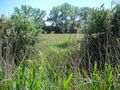
Hashpoint unreachable due to water. Yet close enough.
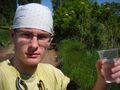
Toast. For all brave geohashers.
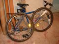
My poor disassambled bike.


Achievements
Ravise earned the 2014 Geohashing Day achievement
|