Difference between revisions of "2014-05-23 47 -122"
From Geohashing
imported>Thomcat ([live picture] Someone left the cake out in the rain... [http://www.openstreetmap.org/?lat=47.64029457&lon=-122.10273125&zoom=16&layers=B000FTF @47.6403,-122.1027]) |
imported>Thomcat ([live picture] Hashiversary! [http://www.openstreetmap.org/?lat=47.64029777&lon=-122.10272112&zoom=16&layers=B000FTF @47.6403,-122.1027]) |
||
| Line 34: | Line 34: | ||
Image:2014-05-23_47_-122_thomcat_1400872383312.jpg | Someone left the cake out in the rain... [http://www.openstreetmap.org/?lat=47.64029457&lon=-122.10273125&zoom=16&layers=B000FTF @47.6403,-122.1027] | Image:2014-05-23_47_-122_thomcat_1400872383312.jpg | Someone left the cake out in the rain... [http://www.openstreetmap.org/?lat=47.64029457&lon=-122.10273125&zoom=16&layers=B000FTF @47.6403,-122.1027] | ||
| + | |||
| + | Image:2014-05-23_47_-122_thomcat_1400872498421.jpg | [[Hashiversary]]! [http://www.openstreetmap.org/?lat=47.64029777&lon=-122.10272112&zoom=16&layers=B000FTF @47.6403,-122.1027] | ||
</gallery> | </gallery> | ||
Revision as of 19:16, 23 May 2014
| Fri 23 May 2014 in Seattle: 47.6403037, -122.1027419 geohashing.info google osm bing/os kml crox |
Location
On a residential street in front of 17810 NE 34th St in Redmond, just west of Lake Sammamish.
Participants
Plans
Lunchtime visit, then take the toll bridge back to Seattle (specifically sometime between 10 and 2).
Expedition
Tracklog
Photos
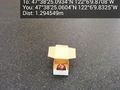
Someone left the cake out in the rain... @47.6403,-122.1027


Achievements