Difference between revisions of "2014-06-12 51 9"
From Geohashing
imported>GeorgDerReisende (new expedition to Fuldatal-Ihringshausen) |
imported>GeorgDerReisende (expedition report added) |
||
| Line 20: | Line 20: | ||
== Expedition == | == Expedition == | ||
| − | |||
| − | + | I walked from home to the hash and found it on the field. But the field was not to walk on it, because on Wednesday we had a big thunderstorm around here, and the field was very wet. The surface was some sort of dry, but the underground felt like a swamp. | |
| − | |||
== Photos == | == Photos == | ||
| − | |||
| − | |||
| − | |||
<gallery perrow="5"> | <gallery perrow="5"> | ||
| + | Image:2014-06-12 51 9 GeorgDerReisende 2039.jpg | 30 meters to hash | ||
| + | Image:2014-06-12 51 9 GeorgDerReisende 2040.jpg | dito | ||
| + | Image:2014-06-12 51 9 GeorgDerReisende 2047.jpg | the unlucky geohasher | ||
| + | Image:2014-06-12 51 9 GeorgDerReisende 2048.jpg | view to Ihringshausen | ||
| + | Image:2014-06-12 51 9 GeorgDerReisende 2053.jpg | view to the former stream | ||
</gallery> | </gallery> | ||
| − | |||
| − | |||
| − | |||
| − | |||
| − | |||
| − | |||
| − | |||
| − | |||
| − | |||
| − | |||
| − | |||
| − | |||
| − | |||
| − | |||
| − | |||
| − | |||
| − | |||
[[Category:Expeditions]] | [[Category:Expeditions]] | ||
| − | |||
| − | |||
| − | |||
| − | |||
| − | |||
| − | |||
| − | |||
| − | |||
| − | |||
| − | |||
| − | |||
| − | |||
| − | |||
[[Category:Not reached - Mother Nature]] | [[Category:Not reached - Mother Nature]] | ||
| − | |||
| − | |||
| − | |||
| − | |||
| − | |||
| − | |||
| − | |||
| − | |||
| − | |||
| − | |||
| − | |||
Revision as of 22:27, 12 June 2014
| Thu 12 Jun 2014 in 51,9: 51.3533276, 9.5028548 geohashing.info google osm bing/os kml crox |
Location
The hash lies on a field in Fuldatal-Ihringshausen.
Participants
Plans
Walk there from home. Make a Tron, maybe a Déjà vu.
Expedition
I walked from home to the hash and found it on the field. But the field was not to walk on it, because on Wednesday we had a big thunderstorm around here, and the field was very wet. The surface was some sort of dry, but the underground felt like a swamp.
Photos
30 meters to hash
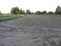
dito

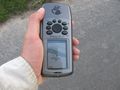
the unlucky geohasher
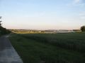
view to Ihringshausen
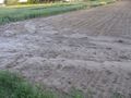
view to the former stream


