Difference between revisions of "2014-06-22 45 -123"
imported>Michael5000 (→Photos) |
imported>Michael5000 (→Achievements) |
||
| Line 50: | Line 50: | ||
| − | |||
| − | |||
| − | |||
| − | |||
| − | |||
| − | |||
| − | |||
| − | |||
| − | |||
| − | |||
| − | |||
| − | |||
[[Category:Expeditions]] | [[Category:Expeditions]] | ||
| − | |||
[[Category:Expeditions with photos]] | [[Category:Expeditions with photos]] | ||
| − | |||
| − | |||
| − | |||
| − | |||
| − | |||
[[Category:Coordinates reached]] | [[Category:Coordinates reached]] | ||
| − | |||
| − | |||
| − | |||
| − | |||
| − | |||
| − | |||
| − | |||
| − | |||
| − | |||
| − | |||
| − | |||
| − | |||
| − | |||
| − | |||
| − | |||
| − | |||
| − | |||
| − | |||
Revision as of 21:29, 22 June 2014
| Sun 22 Jun 2014 in 45,-123: 45.2920665, -123.9609655 geohashing.info google osm bing/os kml crox |
Location
In dunes south of Cape Lookout.
Participants
Expedition
Up at dawn! And about 66 straight-line miles (100 kilometers, and exactly 100 times the distance as my previous expedition) of driving brought me to the coast near Pacific City.
The hashpoint was about as unpleasant as a point on the beach could be, for it was in the midst of a large encampment of ATV enthusiasts. All-Terrain Vehicles combine the advantages of being very expensive and frightfully dangerous toys with the excitement of driving around in circles at a moderate speed and the relaxation of a camping trip surrounded by dozens of roaring lawnmowers. But then, they probably don't "get" my hobby, either.
I drove in to a parking lot that was about a third of a mile from the hashpoint. I walked across the dunes, which marked me as an outsider, and arrived at a little copse of pines that was at the actual hashpoint. Because I arrived in the calm of the morning, my ambition to fly my kite at the hashpoint was defeated; an hour later, the wind would have been up. It was almost exactly 8:30 as I started back to the parking lot, and by rule or convention that is apparently when the calm of the morning ends in ATV terms. The place was really starting to roar as I got back to the car and proceeded on towards breakfast.
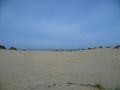
Photos
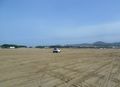
Looking from the parking lot towards the hashpoint
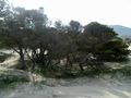
The hashpoint is inside this little copse
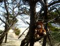
Relaxing in the hashtree
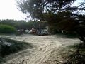
Some ATVers who, if they only knew it, are camping a stone's throw from the hashpoint
The ocean is just over yonder


