Difference between revisions of "2014-06-24 52 9"
From Geohashing
imported>GeorgDerReisende (new expedition to Essel) |
imported>GeorgDerReisende (expedition report added) |
||
| Line 1: | Line 1: | ||
| − | |||
| − | |||
| − | |||
| − | |||
| − | |||
| − | |||
| − | |||
| − | |||
| − | |||
| − | |||
{{meetup graticule | {{meetup graticule | ||
| lat=52 | | lat=52 | ||
| Line 18: | Line 8: | ||
__NOTOC__ | __NOTOC__ | ||
== Location == | == Location == | ||
| − | + | ||
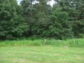
| + | The hash lied on a meadow near the service station Allertal. | ||
== Participants == | == Participants == | ||
| − | + | ||
| − | + | [[User:GeorgDerReisende|GeorgDerReisende]] | |
== Plans == | == Plans == | ||
| − | + | ||
| + | What plans? | ||
== Expedition == | == Expedition == | ||
| − | + | ||
| + | I started the journey in Kassel at 10:30, started to hitchhike at 11:00 and got a first car after five minutes. With two more cars I arrived at the service station Allertal at 13:38. Then I walked to the hash. I found it one meter behind the gate to the meadow. | ||
| + | |||
| + | I passed the main road above several times while changing the direction for hitchhiking on the motorway from the eastern (northbound) section to the western (southbound) place, but for a ''Déjà vu geohash achievement'' the road is with 240 meters too far away. | ||
== Tracklog == | == Tracklog == | ||
| Line 34: | Line 29: | ||
== Photos == | == Photos == | ||
| − | |||
| − | |||
| − | |||
<gallery perrow="5"> | <gallery perrow="5"> | ||
| + | Image:2014-06-24 52 9 GeorgDerReisende 2520.jpg | the geocache GC50CEA | ||
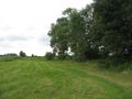
| + | Image:2014-06-24 52 9 GeorgDerReisende 2526.jpg | the way to the hash | ||
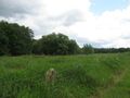
| + | Image:2014-06-24 52 9 GeorgDerReisende 2530.jpg | the hash behind the gate | ||
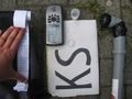
| + | Image:2014-06-24 52 9 GeorgDerReisende 2541.jpg | the proof | ||
| + | Image:2014-06-24 52 9 GeorgDerReisende 2542.jpg | the geohasher | ||
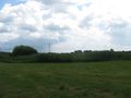
| + | Image:2014-06-24 52 9 GeorgDerReisende 2544.jpg | the east | ||
| + | Image:2014-06-24 52 9 GeorgDerReisende 2545.jpg | the south | ||
| + | Image:2014-06-24 52 9 GeorgDerReisende 2546.jpg | the west | ||
| + | Image:2014-06-24 52 9 GeorgDerReisende 2547.jpg | the north | ||
</gallery> | </gallery> | ||
| Line 44: | Line 45: | ||
<!-- Add any achievement ribbons you earned below, or remove this section --> | <!-- Add any achievement ribbons you earned below, or remove this section --> | ||
| + | {{Thumbs Up | latitude = 52 | longitude = 9 | date = 2014-06-24 | name = GeorgDerReisende }} | ||
| − | + | {{Hash collision | latitude = 52 | longitude = 9 | date = 2014-06-24 | name = GeorgDerReisende | link = http://coord.info/GC50CEA | id = GC50CEA | distance = 0.498 km | honor = yes }} | |
| − | |||
| − | |||
| − | + | [[Category:Expeditions]] | |
| − | + | [[Category:Expeditions with photos]] | |
| − | |||
| − | [[Category: | ||
| − | |||
| − | |||
| − | |||
| − | |||
| − | |||
| − | |||
| − | |||
| − | |||
| − | |||
| − | |||
[[Category:Coordinates reached]] | [[Category:Coordinates reached]] | ||
| − | |||
| − | |||
| − | |||
| − | |||
| − | |||
| − | |||
| − | |||
| − | |||
| − | |||
| − | |||
| − | |||
| − | |||
| − | |||
| − | |||
| − | |||
| − | |||
| − | |||
| − | |||
Revision as of 18:06, 24 June 2014
| Tue 24 Jun 2014 in 52,9: 52.6921693, 9.6825208 geohashing.info google osm bing/os kml crox |
Location
The hash lied on a meadow near the service station Allertal.
Participants
Plans
What plans?
Expedition
I started the journey in Kassel at 10:30, started to hitchhike at 11:00 and got a first car after five minutes. With two more cars I arrived at the service station Allertal at 13:38. Then I walked to the hash. I found it one meter behind the gate to the meadow.
I passed the main road above several times while changing the direction for hitchhiking on the motorway from the eastern (northbound) section to the western (southbound) place, but for a Déjà vu geohash achievement the road is with 240 meters too far away.
Tracklog
Photos
the geocache GC50CEA
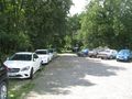
the way to the hash
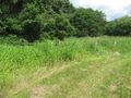
the hash behind the gate
the proof
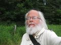
the geohasher
the east
the south
the west
the north


Achievements
GeorgDerReisende earned the Thumbs Up Geohash Achievement
|
GeorgDerReisende earned the Hash collision honorable mention
|