Difference between revisions of "2014-07-11 48 9"
imported>DODO m (→Gallery) |
imported>Ekorren (Gallery and small report) |
||
| Line 15: | Line 15: | ||
== Expedition == | == Expedition == | ||
| − | + | This should have been a "collecting kilometres" trip - but, as always with my trips, I couldn't get myself to take the fast and boring route. So I didn't go along the valley but instead went to Grafenberg first, from there up the Albtrauf to Kohlberg, then along the mountainside and back into the valley not before Dettingen. Well, that was a lot more upwards slope, and partly bad trails, but with a number of really nice views from the mountains it actually was worth it. | |
| + | |||
| + | I reached Bad Urach and went for the hash on the other side of a smaller valley. Climbed up on a small residential road, then a hiking path, then just through the forest. Surprisingly enough, the forest was easy to pass just where I needed it - in an otherwise extremely steep slope with lots of bushes and a few fences. When I reached the hash, the surprise was even larger: A little opening with a really good view over the city! So I had discovered a totally unknown but good viewpoint. | ||
| + | |||
| + | Went into town for a little time, then back home on a faster route. No unnecessary mountains this time ;) | ||
== Gallery == | == Gallery == | ||
<gallery> | <gallery> | ||
| − | + | 2014-07-11_48_9_5683.JPG|If driving you should make sure your wheels agree on one direction. | |
| + | 2014-07-11_48_9_5685.JPG | ||
| + | 2014-07-11_48_9_5687.JPG | ||
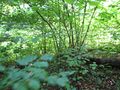
| + | 2014-07-11_48_9_5688.JPG|Attention swimmers! Danger by twining plants | ||
| + | 2014-07-11_48_9_5689.JPG | ||
| + | 2014-07-11_48_9_5692.JPG | ||
| + | 2014-07-11_48_9_5693.JPG|Forest art | ||
| + | 2014-07-11_48_9_5696.JPG | ||
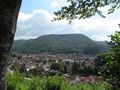
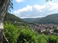
| + | 2014-07-11_48_9_5698.JPG|View into the Erms valley | ||
| + | 2014-07-11_48_9_5699.JPG|This is supposed to be a cycle trail? Guess not... | ||
| + | 2014-07-11_48_9_5700.JPG | ||
| + | 2014-07-11_48_9_5701.JPG | ||
| + | 2014-07-11_48_9_5702.JPG|Castle ruins Hohenurach | ||
| + | 2014-07-11_48_9_5703.JPG|There should be another sign pointing to the hash. | ||
| + | 2014-07-11_48_9_5706.JPG|Through the forest... | ||
| + | 2014-07-11_48_9_5708.JPG | ||
| + | 2014-07-11_48_9_5711.JPG|Coordinates reached | ||
| + | 2014-07-11_48_9_5713.JPG|Hash trees | ||
| + | 2014-07-11_48_9_5715.JPG | ||
| + | 2014-07-11_48_9_5709.JPG|View from hash | ||
| + | 2014-07-11_48_9_5712.JPG | ||
| + | 2014-07-11_48_9_5714.JPG | ||
| + | 2014-07-11_48_9_5716.JPG|Hash berries | ||
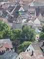
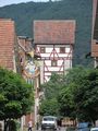
| + | 2014-07-11_48_9_5717.JPG|Bad Urach old town centre | ||
| + | 2014-07-11_48_9_5719.JPG | ||
| + | 2014-07-11_48_9_5721.JPG|Cycle trail | ||
</gallery> | </gallery> | ||
[[Category:Expedition planning]] | [[Category:Expedition planning]] | ||
| − | |||
| − | |||
[[Category:Expeditions]] | [[Category:Expeditions]] | ||
[[Category:Expeditions with photos]] | [[Category:Expeditions with photos]] | ||
[[Category:Coordinates reached]] | [[Category:Coordinates reached]] | ||
| − | |||
Revision as of 13:06, 22 October 2014
| Fri 11 Jul 2014 in 48,9: 48.4977344, 9.4041709 geohashing.info google osm bing/os kml crox |
Contents
Location
Bad Urach, a piece of foresty steep slope
Participants
Ekorren went there by bike
Expedition
This should have been a "collecting kilometres" trip - but, as always with my trips, I couldn't get myself to take the fast and boring route. So I didn't go along the valley but instead went to Grafenberg first, from there up the Albtrauf to Kohlberg, then along the mountainside and back into the valley not before Dettingen. Well, that was a lot more upwards slope, and partly bad trails, but with a number of really nice views from the mountains it actually was worth it.
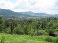
I reached Bad Urach and went for the hash on the other side of a smaller valley. Climbed up on a small residential road, then a hiking path, then just through the forest. Surprisingly enough, the forest was easy to pass just where I needed it - in an otherwise extremely steep slope with lots of bushes and a few fences. When I reached the hash, the surprise was even larger: A little opening with a really good view over the city! So I had discovered a totally unknown but good viewpoint.
Went into town for a little time, then back home on a faster route. No unnecessary mountains this time ;)
Gallery
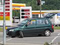
If driving you should make sure your wheels agree on one direction.
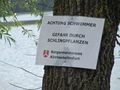
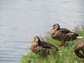
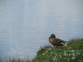
Attention swimmers! Danger by twining plants
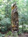
Forest art
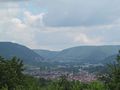
View into the Erms valley
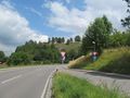
This is supposed to be a cycle trail? Guess not...
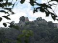
Castle ruins Hohenurach
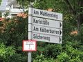
There should be another sign pointing to the hash.
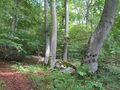
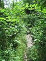
Through the forest...
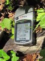
Coordinates reached
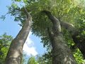
Hash trees
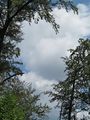
View from hash
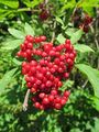
Hash berries
Bad Urach old town centre
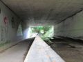
Cycle trail


