Difference between revisions of "2014-08-04 52 9"
From Geohashing
imported>GeorgDerReisende (expedition report added) |
imported>GeorgDerReisende m (typo) |
||
| Line 9: | Line 9: | ||
== Location == | == Location == | ||
| − | The hash | + | The hash lay on a fieldway near Soltau-Tetendorf. |
== Participants == | == Participants == | ||
| Line 25: | Line 25: | ||
== Photos == | == Photos == | ||
<gallery perrow="5"> | <gallery perrow="5"> | ||
| − | Image:2014-08-04 52 9 GeorgDerReisende 3729.jpg | the hash | + | Image:2014-08-04 52 9 GeorgDerReisende 3729.jpg | the hash lay on the entrance to this meadow (and view to the south) |
Image:2014-08-04 52 9 GeorgDerReisende 3733.jpg | proof | Image:2014-08-04 52 9 GeorgDerReisende 3733.jpg | proof | ||
Image:2014-08-04 52 9 GeorgDerReisende 3734.jpg | proof of dance | Image:2014-08-04 52 9 GeorgDerReisende 3734.jpg | proof of dance | ||
Revision as of 19:52, 8 October 2014
| Mon 4 Aug 2014 in 52,9: 52.9723167, 9.8389808 geohashing.info google osm bing/os kml crox |
Location
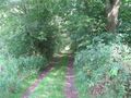
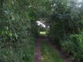
The hash lay on a fieldway near Soltau-Tetendorf.
Participants
Plans
Hitchhiking and walking.
Expedition
I started in Kassel at 11 o'clock. With four cars I arrived at the crossroad of Tetendorf. Then I walked to the hash, I arrived there at 16:20. After the usual questions, is it here? is it there? I found it. Afterwards I walked forth to the national road, where I started to hitchhike home at 16:55, with three cars I arrived at home at 21:00.
Photos
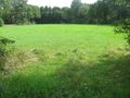
the hash lay on the entrance to this meadow (and view to the south)
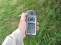
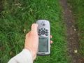
proof
proof of dance
view to the east
view to the west
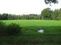
view to the north
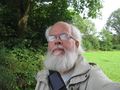
proof of the geohasher


Achievements
GeorgDerReisende earned the Thumbs Up Geohash Achievement
|