Difference between revisions of "2014-08-24 45 -123"
imported>Michael5000 |
imported>FippeBot m (Location) |
||
| (8 intermediate revisions by 2 users not shown) | |||
| Line 1: | Line 1: | ||
| − | |||
| − | [[Image: | + | [[Image:2014-08-24 45 -123 Tree.JPG|The Hashtree|thumb|left]] |
| − | |||
| − | |||
| − | |||
| − | |||
{{meetup graticule | {{meetup graticule | ||
| lat=45 | | lat=45 | ||
| Line 15: | Line 10: | ||
}} | }} | ||
| − | |||
__NOTOC__ | __NOTOC__ | ||
== Location == | == Location == | ||
| Line 24: | Line 18: | ||
*[[User:Michael5000|Michael5000]] | *[[User:Michael5000|Michael5000]] | ||
| + | *[[User:Jiml|Jim]] | ||
== Expedition == | == Expedition == | ||
| − | After a long drought of accessible hashpoints in the region, the appearance of this one made my Sunday plans | + | === Expedition 5000 === |
| + | After a long drought of accessible hashpoints in the region, the appearance of this one made my Sunday plans for me before I was fully out of bed on Friday morning. It was an easy matter to reach the hashpoint, under its delightful huge hashtree, and take a few photos. This set the stage for running on the nearby Banks-Vernonia Trail and a Sunday drive through the little towns of Yamhill County. Splendid. | ||
| + | |||
| + | === Expedition Two === | ||
| + | Jim had also noted the apparent accessibility of this hashpoint, and figured he'd wander by after the Farmer's market. | ||
| + | |||
| + | And he did. | ||
| + | |||
| + | The other item of note were the grapes growing nearby. | ||
== Photos == | == Photos == | ||
| Line 38: | Line 41: | ||
== Achievements == | == Achievements == | ||
{{#vardefine:ribbonwidth|800px}} | {{#vardefine:ribbonwidth|800px}} | ||
| − | + | ||
| + | * Land Geohash | ||
| Line 45: | Line 49: | ||
[[Category:Expeditions with photos]] | [[Category:Expeditions with photos]] | ||
[[Category:Coordinates reached]] | [[Category:Coordinates reached]] | ||
| + | {{location|US|OR|WI}} | ||
Latest revision as of 01:08, 15 August 2019

| Sun 24 Aug 2014 in 45,-123: 45.6193152, -123.0633142 geohashing.info google osm bing/os kml crox |
Location
On a rural road just north of the junction of U.S. 26 and Oregon Highway 6.
Participants
Expedition
Expedition 5000
After a long drought of accessible hashpoints in the region, the appearance of this one made my Sunday plans for me before I was fully out of bed on Friday morning. It was an easy matter to reach the hashpoint, under its delightful huge hashtree, and take a few photos. This set the stage for running on the nearby Banks-Vernonia Trail and a Sunday drive through the little towns of Yamhill County. Splendid.
Expedition Two
Jim had also noted the apparent accessibility of this hashpoint, and figured he'd wander by after the Farmer's market.
And he did.
The other item of note were the grapes growing nearby.
Photos
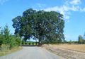
The lovely 2014-08-24 45 -123 hashtree!

View of the expedition vehicle and valley from under the tree.

Achievements
- Land Geohash