Difference between revisions of "2014-09-04 48 15"
imported>Patrizius (→Participants) |
imported>FippeBot m (Location) |
||
| (14 intermediate revisions by 4 users not shown) | |||
| Line 1: | Line 1: | ||
| − | |||
| − | |||
| − | |||
| − | |||
| − | |||
| − | |||
| − | |||
| − | |||
| − | |||
| − | |||
{{meetup graticule | {{meetup graticule | ||
| lat=48 | | lat=48 | ||
| Line 15: | Line 5: | ||
}} | }} | ||
| − | |||
__NOTOC__ | __NOTOC__ | ||
== Location == | == Location == | ||
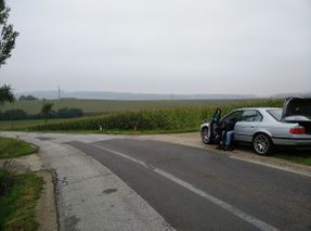
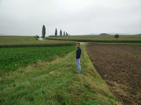
| − | + | [[Image:IMG_20140904_075935_re.jpg | thumb | left | At the left turn of the access road, in the cornfield.]]The hash was located somewhere between Sieghartskirchen and Neulengbach and appeared to be sitting on a field. | |
| − | The hash was located somewhere between Sieghartskirchen and Neulengbach and appeared to be sitting on a field. | + | |
== Participants == | == Participants == | ||
| − | |||
| − | |||
* [[User:Patrizius|Patrizius]] | * [[User:Patrizius|Patrizius]] | ||
* [[User:B2c|B2c]] | * [[User:B2c|B2c]] | ||
| + | |||
== Plans == | == Plans == | ||
| − | + | We had (at least) two options to approach the hash so we decided to go for a [[Tron achievement]], meaning never crossing our own path to and from the hashpoint. Starting out from Vienna we planned to approach the hash from the north (via Tulln) and leave the hashpoint eastbound returning to Vienna via Mauerbach. | |
| + | |||
== Expedition == | == Expedition == | ||
| − | + | Everything went as planned. The hash turned out to be in a corn field. Luckily there was a small access road that would take us closer to the hash, so we didn't have to work our way through the entire field, but only a couple of meters. | |
| − | |||
== Tracklog == | == Tracklog == | ||
| − | + | [[File:Hash-2014-09-04-wien.png]] | |
| + | |||
== Photos == | == Photos == | ||
| − | < | + | <gallery caption="Photo Gallery" widths="320px" heights="213px" perrow="3"> |
| − | Image: | + | Image:IMG_20140904_075501.jpg | Hashcot. Also, alpine boots. |
| − | -- | + | Image:IMG_20140904_080350.jpg | Catcher in the corn. |
| − | + | Image:IMG_20140904_080325.jpg | Stupid grin(tm). | |
| + | Image:Screenshot_2014-09-04-08-03-07.png | Proof. | ||
| + | Image:Screenshot_2014-09-04-08-02-53.png | More Proof. | ||
| + | Image:IMG_20140904 080505.jpg | Every time I try to get out... it pulls me back in! | ||
| + | Image:IMG_20140904_080751.jpg | On the way back to the car, taking the long way around so we don't cross our tracks. | ||
</gallery> | </gallery> | ||
| + | |||
== Achievements == | == Achievements == | ||
{{#vardefine:ribbonwidth|800px}} | {{#vardefine:ribbonwidth|800px}} | ||
| − | |||
| + | {{Tron | ||
| + | | latitude = 48 | ||
| + | | longitude = 15 | ||
| + | | date = 2014-09-04 | ||
| + | | name = B2c | ||
| + | | tracklog = http://www.gpsvisualizer.com/display/20140904141447-81086-map.html | ||
| + | | possessive = his | ||
| + | }} | ||
| − | + | {{Tron | |
| − | + | | latitude = 48 | |
| − | + | | longitude = 15 | |
| + | | date = 2014-09-04 | ||
| + | | name = Patrizius | ||
| + | | tracklog = http://www.gpsvisualizer.com/display/20140904141447-81086-map.html | ||
| + | | possessive = his | ||
| + | }} | ||
| − | + | {{consecutive geohash 2 | |
| + | | count = 2 | ||
| + | | latitude = 47 | ||
| + | | longitude = 14 | ||
| + | | date = 2014-09-03 | ||
| + | | name = B2c | ||
| + | }} | ||
| + | {{consecutive geohash 2 | ||
| + | | count = 2 | ||
| + | | latitude = 47 | ||
| + | | longitude = 14 | ||
| + | | date = 2014-09-03 | ||
| + | | name = Patrizius | ||
| + | }} | ||
| − | |||
| − | |||
| − | |||
| − | |||
| − | |||
| − | |||
[[Category:Expeditions]] | [[Category:Expeditions]] | ||
| − | |||
[[Category:Expeditions with photos]] | [[Category:Expeditions with photos]] | ||
| − | |||
| − | |||
| − | |||
| − | |||
| − | |||
[[Category:Coordinates reached]] | [[Category:Coordinates reached]] | ||
| − | + | {{location|AT|NÖ|PL}} | |
| − | |||
| − | |||
| − | |||
| − | |||
| − | |||
| − | |||
| − | |||
| − | |||
| − | |||
| − | |||
| − | |||
| − | |||
| − | |||
| − | |||
| − | |||
| − | |||
| − | |||
Latest revision as of 01:14, 15 August 2019
| Thu 4 Sep 2014 in 48,15: 48.2273697, 15.9763615 geohashing.info google osm bing/os kml crox |
Location

The hash was located somewhere between Sieghartskirchen and Neulengbach and appeared to be sitting on a field.
Participants
Plans
We had (at least) two options to approach the hash so we decided to go for a Tron achievement, meaning never crossing our own path to and from the hashpoint. Starting out from Vienna we planned to approach the hash from the north (via Tulln) and leave the hashpoint eastbound returning to Vienna via Mauerbach.
Expedition
Everything went as planned. The hash turned out to be in a corn field. Luckily there was a small access road that would take us closer to the hash, so we didn't have to work our way through the entire field, but only a couple of meters.
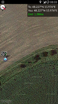
Tracklog

Photos
- Photo Gallery
Hashcot. Also, alpine boots.

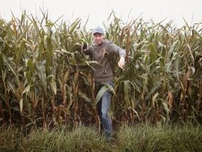
Catcher in the corn.

Stupid grin(tm).
Proof.
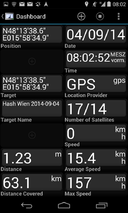
More Proof.
Every time I try to get out... it pulls me back in!
On the way back to the car, taking the long way around so we don't cross our tracks.


Achievements
B2c earned the Tron achievement
|
Patrizius earned the Tron achievement
|
B2c earned the Consecutive geohash achievement
|
Patrizius earned the Consecutive geohash achievement
|