Difference between revisions of "2014-09-06 47 9"
imported>TFTD (Created page with "<!-- If you did not specify these parameters in the template, please substitute appropriate values for IMAGE, LAT, LON, and DATE (YYYY-MM-DD format) Image:{{{image|IMAGE}}...") |
imported>Jiml m (Adjust result codes) |
||
| Line 14: | Line 14: | ||
}} | }} | ||
| − | + | ||
__NOTOC__ | __NOTOC__ | ||
== Location == | == Location == | ||
| − | + | ||
| − | + | In a forest near Tettnang. | |
== Participants == | == Participants == | ||
| − | [[User:TFTD | TFTD]] | + | |
| + | * [[User:TFTD | TFTD]] | ||
== Plans == | == Plans == | ||
| Line 28: | Line 29: | ||
== Expedition == | == Expedition == | ||
After a stressful week I forgot to check for the upcoming hashes of the weekend. I finally thought of it on Saturday at around 14:00 o'clock. To my enjoyment I saw the hash just about 15km away and since I just repaired a flat tire on my bike this morning I thought this would be a good trip to test my work. | After a stressful week I forgot to check for the upcoming hashes of the weekend. I finally thought of it on Saturday at around 14:00 o'clock. To my enjoyment I saw the hash just about 15km away and since I just repaired a flat tire on my bike this morning I thought this would be a good trip to test my work. | ||
| − | So after checking for a route and preparing my equipment I finally started | + | |
| + | So after checking for a route and preparing my equipment I finally started shortly before 3p.m. | ||
| + | So I actually would be at the hash at the meet-up time. I think that's my first time. | ||
| + | So nothing really spectacular was happening. I went by a lot of apple and other fruit plantations. | ||
| + | |||
| + | The last 50 meters I walked, the GPS had some problems but eventually I found the spot. I wandered | ||
| + | around the hash shortly before 4p.m. Since the mosquitoes were attacking me like crazy I decided to | ||
| + | leave as fast as possible. So I took some pictures and made my way back on a different route. | ||
| + | |||
| + | All in all a short and nice 35km tour with nice weather. | ||
== Tracklog == | == Tracklog == | ||
| Line 35: | Line 45: | ||
== Photos == | == Photos == | ||
| − | + | ||
| − | |||
| − | |||
<gallery perrow="5"> | <gallery perrow="5"> | ||
Image:2014-09-06 01.jpg | Hash in the background. Leaving my bike behind for the last meters. | Image:2014-09-06 01.jpg | Hash in the background. Leaving my bike behind for the last meters. | ||
| Line 48: | Line 56: | ||
{{#vardefine:ribbonwidth|800px}} | {{#vardefine:ribbonwidth|800px}} | ||
| − | + | * Land Geohash | |
| + | * Bike geohash | ||
| + | |||
| + | |||
[[Category:Expeditions]] | [[Category:Expeditions]] | ||
[[Category:Expeditions with photos]] | [[Category:Expeditions with photos]] | ||
[[Category:Coordinates reached]] | [[Category:Coordinates reached]] | ||
| − | |||
| − | |||
Revision as of 14:24, 7 September 2014
| Sat 6 Sep 2014 in 47,9: 47.6391881, 9.5978058 geohashing.info google osm bing/os kml crox |
Location
In a forest near Tettnang.
Participants
Plans
As almost always I planned to go by bike.
Expedition
After a stressful week I forgot to check for the upcoming hashes of the weekend. I finally thought of it on Saturday at around 14:00 o'clock. To my enjoyment I saw the hash just about 15km away and since I just repaired a flat tire on my bike this morning I thought this would be a good trip to test my work.
So after checking for a route and preparing my equipment I finally started shortly before 3p.m. So I actually would be at the hash at the meet-up time. I think that's my first time. So nothing really spectacular was happening. I went by a lot of apple and other fruit plantations.
The last 50 meters I walked, the GPS had some problems but eventually I found the spot. I wandered around the hash shortly before 4p.m. Since the mosquitoes were attacking me like crazy I decided to leave as fast as possible. So I took some pictures and made my way back on a different route.
All in all a short and nice 35km tour with nice weather.
Tracklog
If anyone has a suggestion where to upload it permanently I can actually post one.
Photos
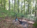
Hash in the background. Leaving my bike behind for the last meters.
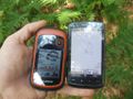
Coordinate proof.
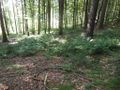
View from the hash.
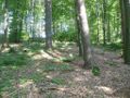
View from the hash.


Achievements
- Land Geohash
- Bike geohash