Difference between revisions of "2014-09-06 47 9"
imported>Jiml m (Adjust result codes) |
imported>TFTD m (→Tracklog) |
||
| Line 42: | Line 42: | ||
== Tracklog == | == Tracklog == | ||
<!-- if your GPS device keeps a log, you may post a link here --> | <!-- if your GPS device keeps a log, you may post a link here --> | ||
| − | + | [http://www.openstreetmap.org/user/TFTD/traces/1876637 Track on OSM] | |
== Photos == | == Photos == | ||
Revision as of 22:00, 2 February 2015
| Sat 6 Sep 2014 in 47,9: 47.6391881, 9.5978058 geohashing.info google osm bing/os kml crox |
Location
In a forest near Tettnang.
Participants
Plans
As almost always I planned to go by bike.
Expedition
After a stressful week I forgot to check for the upcoming hashes of the weekend. I finally thought of it on Saturday at around 14:00 o'clock. To my enjoyment I saw the hash just about 15km away and since I just repaired a flat tire on my bike this morning I thought this would be a good trip to test my work.
So after checking for a route and preparing my equipment I finally started shortly before 3p.m. So I actually would be at the hash at the meet-up time. I think that's my first time. So nothing really spectacular was happening. I went by a lot of apple and other fruit plantations.
The last 50 meters I walked, the GPS had some problems but eventually I found the spot. I wandered around the hash shortly before 4p.m. Since the mosquitoes were attacking me like crazy I decided to leave as fast as possible. So I took some pictures and made my way back on a different route.
All in all a short and nice 35km tour with nice weather.
Tracklog
Photos
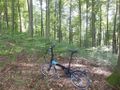
Hash in the background. Leaving my bike behind for the last meters.
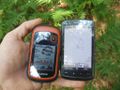
Coordinate proof.
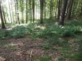
View from the hash.
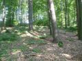
View from the hash.


Achievements
- Land Geohash
- Bike geohash