Difference between revisions of "2014-09-28 54 -3"
From Geohashing
imported>Alexandersmith |
imported>FippeBot m (Location) |
||
| (5 intermediate revisions by 3 users not shown) | |||
| Line 1: | Line 1: | ||
| + | |||
| + | {{meetup graticule | ||
| + | | lat=54 | ||
| + | | lon=-3 | ||
| + | | date=2014-09-28 | ||
| + | }} | ||
== Location == | == Location == | ||
| − | Green Lane, | + | Green Lane, Dalton-in-Furness. |
== Participants == | == Participants == | ||
| − | Currently it is just myself, [[User:Alexandersmith|Alexandersmith]] | + | Currently it is just myself, |
| + | |||
| + | * [[User:Alexandersmith|Alexandersmith]] | ||
| + | |||
| + | Nobody else arrived. | ||
== Plans == | == Plans == | ||
| Line 11: | Line 21: | ||
== Expedition == | == Expedition == | ||
| − | + | After an uneventful cycle ride across Barrow, I reached Green Lane and found the location. There was a car parked on the exact spot, but given the positional accuracy of civilian GPS it was close enough. I was a few minutes early, so I waited but nobody else arrived. I recorded my arrival at the hash and returned home for the write-up. | |
| − | |||
| − | |||
| − | |||
== Photos == | == Photos == | ||
| − | < | + | <gallery perrow="3"> |
| − | Image: | + | Image:20140928 GeohashGeneralLocation.jpg | The meet-up location is conveniently marked by having a car parked on top of it. :-) |
| − | + | Image:20140928 GeohashAutoPhoto.jpg | Auto Photo at the hash location | |
| − | + | Image:20140928_GeohashAchieved.png | Screen capture from the XKCD geohashing app | |
</gallery> | </gallery> | ||
== Achievements == | == Achievements == | ||
{{#vardefine:ribbonwidth|800px}} | {{#vardefine:ribbonwidth|800px}} | ||
| − | |||
| + | {{land geohash | ||
| + | |||
| + | | latitude = 54 | ||
| + | | longitude = -3 | ||
| + | | date = 2014-09-28 | ||
| + | | name = [[User:Alexandersmith|Alexandersmith]] | ||
| + | | image = 20140928_GeohashAutoPhoto.jpg | ||
| + | }} | ||
| − | + | {{bicycle geohash | |
| − | |||
| − | |||
| − | + | | latitude = 54 | |
| + | | longitude = -3 | ||
| + | | date = 2014-09-28 | ||
| + | | name = [[User:Alexandersmith|Alexandersmith]] | ||
| + | | distance = 9.4 miles | ||
| + | | bothways = true | ||
| + | | image = 20140928_GeohashAutoPhoto.jpg | ||
| − | + | }} | |
| − | |||
| − | |||
| − | |||
| − | |||
[[Category:Expeditions]] | [[Category:Expeditions]] | ||
| − | |||
[[Category:Expeditions with photos]] | [[Category:Expeditions with photos]] | ||
| − | |||
| − | |||
| − | |||
| − | |||
| − | |||
[[Category:Coordinates reached]] | [[Category:Coordinates reached]] | ||
| − | + | {{location|GB|ENG|CMA}} | |
| − | |||
| − | |||
| − | |||
| − | |||
| − | |||
| − | |||
| − | |||
| − | |||
| − | |||
| − | |||
| − | |||
| − | |||
| − | |||
| − | |||
| − | |||
| − | |||
| − | |||
| − | |||
| − | |||
Latest revision as of 01:38, 15 August 2019
| Sun 28 Sep 2014 in 54,-3: 54.1497133, -3.1861790 geohashing.info google osm bing/os kml crox |
Location
Green Lane, Dalton-in-Furness.
Participants
Currently it is just myself,
Nobody else arrived.
Plans
I am planning to cycle there, it will take me about 30 minutes. The location is a quiet suburban street, and it should not be a problem to reach.
Expedition
After an uneventful cycle ride across Barrow, I reached Green Lane and found the location. There was a car parked on the exact spot, but given the positional accuracy of civilian GPS it was close enough. I was a few minutes early, so I waited but nobody else arrived. I recorded my arrival at the hash and returned home for the write-up.
Photos
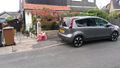
The meet-up location is conveniently marked by having a car parked on top of it. :-)
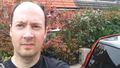
Auto Photo at the hash location
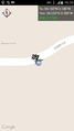
Screen capture from the XKCD geohashing app


Achievements
Alexandersmith earned the Land geohash achievement
|
Alexandersmith earned the Bicycle geohash achievement
|