Difference between revisions of "2014-09-28 39 -77"
From Geohashing
imported>OfficeLinebacker (An expedition message sent via Geohash Droid for Android.) |
imported>FippeBot m (Location) |
||
| (11 intermediate revisions by 2 users not shown) | |||
| Line 9: | Line 9: | ||
And DON'T FORGET to add your expedition and the best photo you took to the gallery on the Main Page! We'd love to read your report, but that means we first have to discover it! :) | And DON'T FORGET to add your expedition and the best photo you took to the gallery on the Main Page! We'd love to read your report, but that means we first have to discover it! :) | ||
--> | --> | ||
| − | + | {{meetup graticule | |
| − | | lat= | + | | lat=39 |
| − | | lon= | + | | lon=-77 |
| − | | date= | + | | date=2014-09-28 |
| − | }} | + | }} |
| − | |||
__NOTOC__ | __NOTOC__ | ||
== Location == | == Location == | ||
| − | + | ||
| + | In someone's back yard near Washington Grove, Maryland | ||
== Participants == | == Participants == | ||
| − | + | ||
| − | + | * [[User:OfficeLinebacker|OfficeLinebacker]] | |
== Plans == | == Plans == | ||
| − | + | ||
| + | To ride my bike there and back. About 15 miles total, no big deal. | ||
== Expedition == | == Expedition == | ||
| − | + | ||
| + | I mounted my trusty steed and set out. The way took me through the picturesque town of Washington Grove and a MARC station I accidentally got off at a few weeks ago. I proceeded to the address and leaned my bike against a lamp post. The hash point itself was in a fenced-in back yard with a very high fence and a really well landscaped back yard. I got to within 49 feet and took a pic. | ||
| + | |||
| + | I rode back via a slightly different route. I great a workout and it was fun. | ||
== Tracklog == | == Tracklog == | ||
| Line 34: | Line 38: | ||
== Photos == | == Photos == | ||
| − | + | ||
| − | |||
| − | |||
<gallery perrow="5"> | <gallery perrow="5"> | ||
| + | Image:2014-09-28_39_-77_12-52-22-164.jpg | Almost there [http://www.openstreetmap.org/?lat=39.14950000&lon=-77.18590000&zoom=16&layers=B000FTF @39.1495,-77.1859] | ||
| + | Image:2014-09-28_39_-77_12-55-47-398.jpg | As close as I got--49 feet [http://www.openstreetmap.org/?lat=39.14960000&lon=-77.18610000&zoom=16&layers=B000FTF @39.1496,-77.1861] | ||
| + | Image:2014-09-28_39_-77_12-57-05-785.jpg | The way there [http://www.openstreetmap.org/?lat=39.14950000&lon=-77.18590000&zoom=16&layers=B000FTF @39.1495,-77.1859] | ||
</gallery> | </gallery> | ||
== Achievements == | == Achievements == | ||
{{#vardefine:ribbonwidth|800px}} | {{#vardefine:ribbonwidth|800px}} | ||
| − | |||
| + | {{bicycle geohash | ||
| + | | latitude = 39 | ||
| + | | longitude = -77 | ||
| + | | date = 2014-09-28 | ||
| + | | name = OfficeLinebacker | ||
| + | | distance = 15 miles | ||
| + | | bothways = true | ||
| + | | image = 2014-09-28_39_-77_12-52-22-164.jpg | ||
| + | }} | ||
| + | |||
| + | {{No trespassing | ||
| + | | latitude = 39 | ||
| + | | longitude = -77 | ||
| + | | date = 2014-09-28 | ||
| + | | name = OfficeLinebacker | ||
| + | | distance = 49 feet | ||
| + | }} | ||
| − | |||
| − | |||
| − | |||
| − | |||
| − | |||
| − | |||
| − | |||
| − | |||
| − | |||
[[Category:Expeditions]] | [[Category:Expeditions]] | ||
| − | + | ||
| − | [[Category:Expeditions with photos]] | + | [[Category:Expeditions with photos]] |
| − | |||
| − | |||
| − | |||
| − | |||
| − | |||
[[Category:Coordinates reached]] | [[Category:Coordinates reached]] | ||
| − | + | {{location|US|MD|MO}} | |
| − | |||
| − | |||
| − | |||
| − | |||
| − | |||
| − | |||
| − | |||
| − | |||
| − | |||
| − | |||
| − | |||
| − | |||
| − | |||
| − | |||
| − | |||
| − | |||
| − | |||
| − | |||
| − | |||
Latest revision as of 01:37, 15 August 2019
| Sun 28 Sep 2014 in 39,-77: 39.1497133, -77.1861790 geohashing.info google osm bing/os kml crox |
Location
In someone's back yard near Washington Grove, Maryland
Participants
Plans
To ride my bike there and back. About 15 miles total, no big deal.
Expedition
I mounted my trusty steed and set out. The way took me through the picturesque town of Washington Grove and a MARC station I accidentally got off at a few weeks ago. I proceeded to the address and leaned my bike against a lamp post. The hash point itself was in a fenced-in back yard with a very high fence and a really well landscaped back yard. I got to within 49 feet and took a pic.
I rode back via a slightly different route. I great a workout and it was fun.
Tracklog
Photos
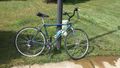
Almost there @39.1495,-77.1859
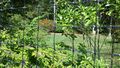
As close as I got--49 feet @39.1496,-77.1861
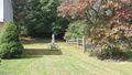
The way there @39.1495,-77.1859


Achievements
OfficeLinebacker earned the Bicycle geohash achievement
|
OfficeLinebacker earned the No trespassing consolation prize
|