Difference between revisions of "2014-09-28 49 12"
imported>DODO (→Photos) |
imported>DODO (→Achievements) |
||
| Line 53: | Line 53: | ||
<!-- Add any achievement ribbons you earned below, or remove this section --> | <!-- Add any achievement ribbons you earned below, or remove this section --> | ||
| + | {{land geohash | ||
| − | + | | latitude = 49 | |
| − | + | | longitude = 12 | |
| − | + | | date = 2014-09-28 | |
| + | | name = DODO | ||
| + | }} | ||
| − | |||
| − | |||
| − | |||
| − | |||
| − | |||
| − | |||
| − | |||
[[Category:Expeditions]] | [[Category:Expeditions]] | ||
| − | |||
[[Category:Expeditions with photos]] | [[Category:Expeditions with photos]] | ||
| − | |||
| − | |||
| − | |||
| − | |||
| − | |||
[[Category:Coordinates reached]] | [[Category:Coordinates reached]] | ||
| − | |||
| − | |||
| − | |||
| − | |||
| − | |||
| − | |||
| − | |||
| − | |||
| − | |||
| − | |||
| − | |||
| − | |||
| − | |||
| − | |||
| − | |||
| − | |||
| − | |||
| − | |||
Revision as of 20:14, 5 October 2014
| Sun 28 Sep 2014 in 49,12: 49.1497133, 12.1861790 geohashing.info google osm bing/os kml crox |
Location
In the forest near Karlstein in the Bayerischer Wald.
Participants
Plans
I had to drive back from Passau to Speyer and wanted to make a short stop here on my way back.
Expedition
There were several time constrains last evening and this morning, and so this tour was lousy planned. All I had was the waypoint on my gps-device and the grey field shown by the hashdroid. After leaving the autobahn, nearly 6 KM away from the hashpoint I had to do some random drives, but at least I landed in Karlstein. I left my car there and decided to walk the last kilometer. That was a good decision, and after a short and nice walk I reached the point. I found it already occupied by a mushroom. I took some pictures and walked the same way back. After that I got a call, that I should drive via Singen/Hohentwiel so I had no time to visit any further hashpoints.
Tracklog
Photos
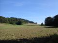
landscape in the Bayerischer Wald
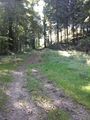
the way to the hash
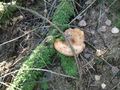
The hashpoint is already occupied
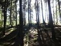
view from the hash (in any direction)
proof


Achievements
DODO earned the Land geohash achievement
|