Difference between revisions of "2014-10-24 52 10"
imported>GeorgDerReisende (expedition report for Schellerten-Bettmar) |
imported>FippeBot m (Location) |
||
| Line 51: | Line 51: | ||
[[Category:Not reached - Mother Nature]] | [[Category:Not reached - Mother Nature]] | ||
| + | {{location|DE|NI|HI}} | ||
Latest revision as of 01:48, 15 August 2019
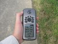
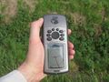
| Fri 24 Oct 2014 in 52,10: 52.1565371, 10.0531705 geohashing.info google osm bing/os kml crox |
Location
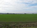
The hash lies in the fields south of Bettmar.
This means the Bettmar lying near Hildesheim. At the same national road exist an other Bettmar, near Vechelde, 23 km eastward.
Participants
Plans
Hitchhiking to the service station Hildesheimer Börde and walking to the hash. Arrival at about 13:30.
Expedition
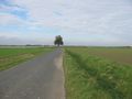
I left home at 9:25, started to hitchhike at 10:00, got a car after 20 minutes to the service station Göttingen, there, after five minutes I got a truck to the service station Hildesheimer Börde. There I arrived at 12:00. Then I walked to the hash. I arrived and found it 20 meters in the field. It was fresh seeded and the ground was wet, so I didn't try to walk onto the field.
Photos
20 meters!
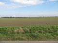
20 meters in this field (and view to the east)
the fieldway has three meters, the ditch with the green about 2.80 m (view to the north)
20 meters are much more than five meters

the unlucky geohasher
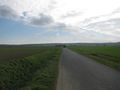
view to the south
view to the west


