Difference between revisions of "2014-11-01 49 8"
imported>DODO (→Plans) |
imported>FippeBot m (Location) |
||
| (8 intermediate revisions by 2 users not shown) | |||
| Line 1: | Line 1: | ||
| − | |||
| − | |||
| − | |||
| − | |||
| − | |||
| − | |||
| − | |||
| − | |||
| − | |||
| − | |||
{{meetup graticule | {{meetup graticule | ||
| lat=49 | | lat=49 | ||
| Line 15: | Line 5: | ||
}} | }} | ||
| − | |||
__NOTOC__ | __NOTOC__ | ||
== Location == | == Location == | ||
| − | + | ||
On a field near Grenzhof. | On a field near Grenzhof. | ||
== Participants == | == Participants == | ||
| − | + | ||
| − | + | [[User:ilpadre|ilpadre]] | |
| + | and, separately, | ||
[[User:DODO|DODO]] | [[User:DODO|DODO]] | ||
== Plans == | == Plans == | ||
| − | + | ||
| − | Before I'll go rowing, I have to drive to Heidelberg surprisingly. So I come along todays hashpoint with nearly no detour. How couldn't I try? Will start now (1 pm) and be there in an hour. | + | [[User:ilpadre|ilpadre]]: I looked up the coordinates on Friday and knew I had to go - finally a hashpoint in walking distance, on a Saturday, while I'm in Heidelberg with no other plans. Unfortunately, I only announced it on the graticule page, and too late for [[User:DODO|DODO]] to take notice, and went there before [[User:DODO|DODO]] announced his own expedition - so no meetup. Too bad. Hope he'll find my marker! |
| + | |||
| + | [[User:DODO|DODO]]: Before I'll go rowing, I have to drive to Heidelberg surprisingly. So I come along todays hashpoint with nearly no detour. How couldn't I try? Will start now (1 pm) and be there in an hour. | ||
== Expedition == | == Expedition == | ||
| − | + | [[User:ilpadre|ilpadre]]: I walked there. We had a very foggy morning in this part of Germany, so the plants in the field were wet, and walking the last 60 meters to the hashpoint made my shoes and socks as wet as if I had walked through waist-deep water. The sun came out on the way back. All in all it was a nice, but rather uneventful walking expedition. | |
| + | |||
| + | |||
| + | [[User:DODO|DODO]]: This morning, Silke and her friend came here from a party and asked, if I could drive them home to Heidelberg on my way to the rowing club. Of course I agreed and then I remembered, that the hashpoint - which I had already given up - was somewhere west of Heidelberg. From now on, everything went pretty fast. Loading the point to my Garmin, preparing my rowing clothes, writing a short plan on the wiki and start to Heidelberg-Pfaffengrund. The way to the rowing club from there via the hashpoint is even shorter than the fastest way. I parked the car on the way that leads to the hashpoint, just 300 m lfrom the point but I couldn't really decide, where to enter the field, and so I walked some more meters. Two people stood there with two model helicopters but they were so absorbed that they hardly noticed me. | ||
| + | |||
| + | As the plants on the field wont be harvested but are just soil conditioner, I decided that I could enter the field. The last 70 m into it were not so wet as this morning, but still muddy. The search for the best entry took some time and so I had to hurry to arrive at the rowing club in time. So I didn't remark ilpadres marker (and maybe the cars of the helicopter-men have destroyed it). | ||
== Tracklog == | == Tracklog == | ||
| − | + | ilpadre: http://www.sports-tracker.com/#/workout/ilpadre/5454c537e4b0cc1b266c04fb | |
| + | |||
| + | DODO: [http://www.gpsies.com/map.do?fileId=lkrfkriitohczaok 16 KM by car + 1 by foot] | ||
== Photos == | == Photos == | ||
| − | |||
| − | |||
| − | |||
<gallery perrow="5"> | <gallery perrow="5"> | ||
| + | File:2014-11-01 49 8 ilpadre stupidgrin.jpg|Obligatory | ||
| + | File:2014-11-01 49 8 ilpadre marker.jpg|I could have made also a K, C and D, but I figured killing two plants was enough. You can also see my wet footprints around. | ||
| + | </gallery> | ||
| + | |||
| + | <gallery perrow="5"> | ||
| + | File:2014-11-01_49_ 8-1.jpg|View to the hash from the car | ||
| + | File:2014-11-01_49_ 8-2.jpg|If you look close, you'll find the helicopter | ||
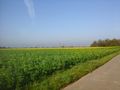
| + | File:2014-11-01_49_ 8-3.jpg|Somewhere in there | ||
| + | File:2014-11-01_49_ 8-4.jpg|I decided to enter the field from here | ||
| + | File:2014-11-01_49_ 8-5.jpg|proof | ||
| + | File:2014-11-01_49_ 8-10.png|another proof | ||
| + | File:2014-11-01_49_ 8-6.jpg|stupi grin | ||
| + | File:2014-11-01_49_ 8-8.jpg|view to the east | ||
| + | File:2014-11-01_49_ 8-9.jpg|and to the south | ||
</gallery> | </gallery> | ||
== Achievements == | == Achievements == | ||
{{#vardefine:ribbonwidth|800px}} | {{#vardefine:ribbonwidth|800px}} | ||
| − | |||
| + | {{Walk geohash | latitude = 49 | longitude = 8 | date = 2014-11-01 | name = [[User:ilpadre|ilpadre]] | distance = 18.3 km}} | ||
| − | + | {{land geohash | |
| − | + | | latitude = 49 | |
| − | + | | longitude = 8 | |
| + | | date = 2014-11-01 | ||
| + | | name = DODO | ||
| + | }} | ||
| − | |||
| − | |||
| − | |||
| − | |||
| − | |||
| − | |||
[[Category:Expeditions]] | [[Category:Expeditions]] | ||
| − | |||
[[Category:Expeditions with photos]] | [[Category:Expeditions with photos]] | ||
| − | |||
| − | |||
| − | |||
| − | |||
| − | |||
[[Category:Coordinates reached]] | [[Category:Coordinates reached]] | ||
| − | + | {{location|DE|BW|HD|city=true}} | |
| − | |||
| − | |||
| − | |||
| − | |||
| − | |||
| − | |||
| − | |||
| − | |||
| − | |||
| − | |||
| − | |||
| − | |||
| − | |||
| − | |||
| − | |||
| − | |||
| − | |||
Latest revision as of 01:51, 15 August 2019
| Sat 1 Nov 2014 in 49,8: 49.4224011, 8.6065222 geohashing.info google osm bing/os kml crox |
Location
On a field near Grenzhof.
Participants
Plans
ilpadre: I looked up the coordinates on Friday and knew I had to go - finally a hashpoint in walking distance, on a Saturday, while I'm in Heidelberg with no other plans. Unfortunately, I only announced it on the graticule page, and too late for DODO to take notice, and went there before DODO announced his own expedition - so no meetup. Too bad. Hope he'll find my marker!
DODO: Before I'll go rowing, I have to drive to Heidelberg surprisingly. So I come along todays hashpoint with nearly no detour. How couldn't I try? Will start now (1 pm) and be there in an hour.
Expedition
ilpadre: I walked there. We had a very foggy morning in this part of Germany, so the plants in the field were wet, and walking the last 60 meters to the hashpoint made my shoes and socks as wet as if I had walked through waist-deep water. The sun came out on the way back. All in all it was a nice, but rather uneventful walking expedition.
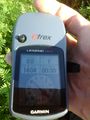
DODO: This morning, Silke and her friend came here from a party and asked, if I could drive them home to Heidelberg on my way to the rowing club. Of course I agreed and then I remembered, that the hashpoint - which I had already given up - was somewhere west of Heidelberg. From now on, everything went pretty fast. Loading the point to my Garmin, preparing my rowing clothes, writing a short plan on the wiki and start to Heidelberg-Pfaffengrund. The way to the rowing club from there via the hashpoint is even shorter than the fastest way. I parked the car on the way that leads to the hashpoint, just 300 m lfrom the point but I couldn't really decide, where to enter the field, and so I walked some more meters. Two people stood there with two model helicopters but they were so absorbed that they hardly noticed me.
As the plants on the field wont be harvested but are just soil conditioner, I decided that I could enter the field. The last 70 m into it were not so wet as this morning, but still muddy. The search for the best entry took some time and so I had to hurry to arrive at the rowing club in time. So I didn't remark ilpadres marker (and maybe the cars of the helicopter-men have destroyed it).
Tracklog
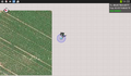
ilpadre: http://www.sports-tracker.com/#/workout/ilpadre/5454c537e4b0cc1b266c04fb
DODO: 16 KM by car + 1 by foot
Photos
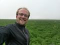
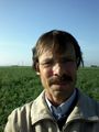
Obligatory
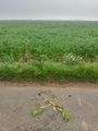
I could have made also a K, C and D, but I figured killing two plants was enough. You can also see my wet footprints around.


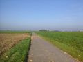
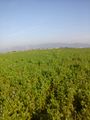
View to the hash from the car
If you look close, you'll find the helicopter
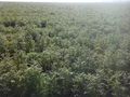
Somewhere in there
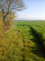
I decided to enter the field from here
proof
another proof
stupi grin
view to the east
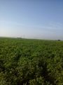
and to the south


Achievements
ilpadre earned the Walk geohash Achievement
|
DODO earned the Land geohash achievement
|