Difference between revisions of "2014-11-16 52 1"
From Geohashing
imported>Sourcerer m (→Added A New Expedition) |
imported>Sourcerer m (→Added A New Expedition) |
||
| Line 1: | Line 1: | ||
{{meetup graticule | {{meetup graticule | ||
| − | | lat= | + | | lat=52 |
| lon=1 | | lon=1 | ||
| date=2014-11-16 | | date=2014-11-16 | ||
| Line 15: | Line 15: | ||
[[User:Sourcerer|Sourcerer]] | [[User:Sourcerer|Sourcerer]] | ||
| − | == Expedition == | + | == Expedition - Fail == |
Sourcerer knew these coordinates could not be reached but he made the attempt any way. Mad or what? | Sourcerer knew these coordinates could not be reached but he made the attempt any way. Mad or what? | ||
| Line 22: | Line 22: | ||
== Photos == | == Photos == | ||
| − | + | ||
| − | |||
| − | |||
<gallery perrow="5"> | <gallery perrow="5"> | ||
| + | Image:2014-11-16 52 1 Sourcerer Artifact 1.jpg|Art Work | ||
| + | Image:2014-11-16 52 1 Sourcerer Artifact 2.jpg|Art Work | ||
| + | Image:2014-11-16 52 1 Sourcerer Artifact 3.jpg|Art Work | ||
| + | Image:2014-11-16 52 1 Sourcerer Fail.jpg|Proof of fail | ||
| + | Image:2014-11-16 52 1 Sourcerer Surf.jpg|North Sea Surf | ||
</gallery> | </gallery> | ||
| − | |||
| − | |||
| − | |||
| − | |||
| − | |||
| − | |||
| − | |||
| − | |||
| − | |||
| − | |||
| − | |||
| − | |||
| − | |||
| − | |||
| − | |||
| − | |||
| − | |||
[[Category:Expeditions]] | [[Category:Expeditions]] | ||
| − | |||
[[Category:Expeditions with photos]] | [[Category:Expeditions with photos]] | ||
| − | |||
| − | |||
| − | |||
| − | |||
| − | |||
| − | |||
| − | |||
| − | |||
| − | |||
[[Category:Coordinates not reached]] | [[Category:Coordinates not reached]] | ||
| − | |||
| − | |||
| − | |||
| − | |||
| − | |||
| − | |||
| − | |||
| − | |||
| − | |||
| − | |||
| − | |||
| − | |||
| − | |||
| − | |||
Revision as of 18:53, 16 November 2014
| Sun 16 Nov 2014 in 52,1: 52.1601714, 1.6072346 geohashing.info google osm bing/os kml crox |
Location
68 metres off shore. Aldburgh, Suffolk, UK.
Participants
Expedition - Fail
Sourcerer knew these coordinates could not be reached but he made the attempt any way. Mad or what?
The hashpoint lay 68 metres out at sea: a boat would have been needed. In failing light, pouring rain and a cold north breeze, Sourcerer almost failed to document the failure. There was one compensation. He located a controversial sculpture, hated and vandalised by some and loved by others. Sourcerer just wanted to get out of the November weather as soon as possible.
Photos
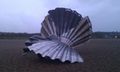
Art Work
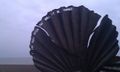
Art Work
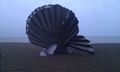
Art Work
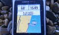
Proof of fail
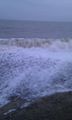
North Sea Surf


