Difference between revisions of "2014-11-26 49 8"
imported>Q-Owl (→Plan) |
imported>Q-Owl |
||
| Line 1: | Line 1: | ||
| − | [[Image:2014-11- | + | [[Image:2014-11-16 49 8 ne.jpg | view to NE in the morning|thumb|left]] {{meetup graticule |
| lat=49 | | lat=49 | ||
| lon=8 | | lon=8 | ||
| Line 7: | Line 7: | ||
== Location == | == Location == | ||
| − | In [http://de.wikipedia.org/wiki/Auerbach_%28Bensheim%29 Bensheim-Auerbach] near a voltage transformation substation and about 100 m | + | In [http://de.wikipedia.org/wiki/Auerbach_%28Bensheim%29 Bensheim-Auerbach] near a voltage transformation substation and about 100 m west of ALDI. |
== Participants == | == Participants == | ||
| Line 21: | Line 21: | ||
== Expedition == | == Expedition == | ||
| − | I reached the | + | I reached the hashpoint area at 07:35. The hashpoint is situated in a little orchard under an elder busch which grows next to the remains of an old apple tree. |
| − | + | The next estate south to the orchard is a voltage transformation substation. | |
| − | |||
| − | + | I took some photos, marked the hashpoint with a big green leaf, smiled and drove to work. | |
| − | + | == Photos == | |
| − | + | <gallery perrow="5" > | |
| + | Image:2014-11-16 49 8 sc.png | proof | ||
| + | Image:2014-11-16 49 8 mark.jpg | hashpoint marked with big green leaf | ||
| + | Image:2014-11-16 49 8 ne.jpg | view to NE in the morning | ||
| + | Image:2014-11-16 49 8 nw.jpg | view to NW | ||
| + | Image:2014-11-16 49 8 s.jpg | view to S: transformation substation | ||
| + | Image:2014-11-16 49 8 grin.jpg | smile | ||
| + | </gallery> | ||
| − | + | More will follow ... | |
| − | |||
| − | |||
| − | |||
<!-- | <!-- | ||
| − | + | Image:2014-11-16 49 8 track.jpg | track to the hp | |
| − | Image:2014-11- | + | Image:2014-11-16 49 8 sc.png | proof |
| − | Image:2014-11- | + | Image:2014-11-16 49 8 mark.jpg | marked hashpoint |
| − | Image:2014-11- | + | Image:2014-11-16 49 8 north.jpg | north |
| − | Image:2014-11- | + | Image:2014-11-16 49 8 west.jpg | west |
| − | Image:2014-11- | + | Image:2014-11-16 49 8 south.jpg | south |
| − | Image:2014-11- | + | Image:2014-11-16 49 8 east.jpg | east |
| − | Image:2014-11- | + | Image:2014-11-16 49 8 happy.jpg | she waited on a bench under big trees |
| − | Image:2014-11- | + | --> |
| − | |||
| − | |||
<!-- | <!-- | ||
List of uploaded Files: | List of uploaded Files: | ||
Revision as of 09:38, 26 November 2014

| Wed 26 Nov 2014 in 49,8: 49.7034316, 8.6082276 geohashing.info google osm bing/os kml crox |
Location
In Bensheim-Auerbach near a voltage transformation substation and about 100 m west of ALDI.
Participants
Plan
Todays hashpoint is less then 1 km from home and about 50 m next to the route I drive to work.^^
So I planned to drive by car near the hash area, walk to the hashpoint, take some photos, return to the car and drive to work.
Nearest geocache: GC46HY5 about 200 m as a deer runs / 250 m walk.
Expedition
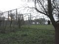
I reached the hashpoint area at 07:35. The hashpoint is situated in a little orchard under an elder busch which grows next to the remains of an old apple tree. The next estate south to the orchard is a voltage transformation substation.
I took some photos, marked the hashpoint with a big green leaf, smiled and drove to work.
Photos
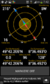
proof
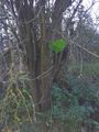
hashpoint marked with big green leaf
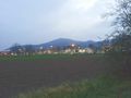
view to NE in the morning
view to NW
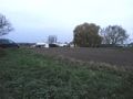
view to S: transformation substation
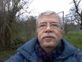
smile


More will follow ...
Achievements / Honorable Mention
Q-Owl earned the Land geohash achievement
|