Difference between revisions of "2015-01-07 47 -117"
imported>Thomcat (Created page with "{{meetup graticule | lat=47 | lon=-117 | date=2015-01-07 | graticule_name=Spokane | graticule_link=Spokane, Washington }} <!-- edit as necessary --> __NOTOC__ == Location =...") |
imported>FippeBot m (Location) |
||
| (9 intermediate revisions by one other user not shown) | |||
| Line 19: | Line 19: | ||
== Expedition == | == Expedition == | ||
| + | An easy drive down the hill led me to Hangman Valley Road, and a short ways up the road to the geohash. I snapped a photo of Hangman Creek on the way. This field was not fenced, lightly dusted in snow, and had a convenient wide spot to park in southeast of the hashpoint. | ||
| + | |||
| + | Took a few photos and then a panorama, uploading the last at 7:37, the sunrise time according to google. Sunrise geohash is an option for weekends, Europe & Asia -- pretty much everywhere except the east and central zones. Sorry guys. | ||
| + | |||
| + | Following that, I headed for Seattle in deep fog. I wasn't in a deep fog, the roadway was. Well, that means I was too - at least until I drove out of it. For grins I snapped a few photos along the way, covering sunset plus one hour, plus two hours, etc. Those photos are below. | ||
| + | |||
== Photos == | == Photos == | ||
| Line 24: | Line 30: | ||
Image:2012-##-## ## ## Alpha.jpg | Witty Comment | Image:2012-##-## ## ## Alpha.jpg | Witty Comment | ||
--> | --> | ||
| − | <gallery perrow=" | + | <gallery perrow="3"> |
| + | |||
| + | |||
| + | Image:2015-01-07_47_-117_thomcat_1420644311363.jpg | Latah creek [http://www.openstreetmap.org/?lat=47.57554184&lon=-117.39051869&zoom=16&layers=B000FTF @47.5755,-117.3905] | ||
| + | |||
| + | Image:2015-01-07_47_-117_thomcat_1420644807413.jpg | [http://www.openstreetmap.org/?lat=47.57412349&lon=-117.38964554&zoom=16&layers=B000FTF @47.5741,-117.3896] | ||
| + | |||
| + | Image:2015-01-07_47_-117_thomcat_1420644889117.jpg | Pano at sunrise [http://www.openstreetmap.org/?lat=47.58713350&lon=-117.40072940&zoom=16&layers=B000FTF @47.5871,-117.4007] | ||
| + | |||
| + | Image:2015-01-07_47_-117_thomcat_sunrise_plus_1.jpg | Sunrise + 1 hour | ||
| + | |||
| + | Image:2015-01-07_47_-117_thomcat_1420652536927.jpg | Sunrise + 2 hours [http://www.openstreetmap.org/?lat=47.10417389&lon=-119.35593769&zoom=16&layers=B000FTF @47.1042,-119.3559] | ||
| + | |||
| + | Image:2015-01-07_47_-117_thomcat_1420656378558.jpg | Sunrise +3 hours [http://www.openstreetmap.org/?lat=47.00751985&lon=-120.57126265&zoom=16&layers=B000FTF @47.0075,-120.5713] | ||
| + | |||
| + | Image:2015-01-07_47_-117_thomcat_1420656388767.jpg | [http://www.openstreetmap.org/?lat=47.00743105&lon=-120.57130496&zoom=16&layers=B000FTF @47.0074,-120.5713] | ||
| + | |||
| + | Image:2015-01-07_47_-117_thomcat_1420656704565.jpg | Lunch panorama [http://www.openstreetmap.org/?lat=47.00689120&lon=-120.56982680&zoom=16&layers=B000FTF @47.0069,-120.5698] | ||
| + | Image:2015-01-07_47_-117_thomcat_1420663329154.jpg | Another hour, another foggy lake. [http://www.openstreetmap.org/?lat=47.59026431&lon=-122.28056716&zoom=16&layers=B000FTF @47.5903,-122.2806] | ||
</gallery> | </gallery> | ||
[[Category:Expeditions]] | [[Category:Expeditions]] | ||
[[Category:Expeditions with photos]] | [[Category:Expeditions with photos]] | ||
| + | [[Category:Coordinates reached]] | ||
| + | {{location|US|WA|SP}} | ||
Latest revision as of 02:21, 15 August 2019
| Wed 7 Jan 2015 in Spokane: 47.5741186, -117.3896544 geohashing.info google osm bing/os kml crox |
Location
Just off Hangman Valley Road, north of previous day's location
Participants
Plans
Visit geohash at sunrise (7:37 am) and get out of town.
Expedition
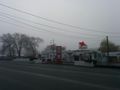
An easy drive down the hill led me to Hangman Valley Road, and a short ways up the road to the geohash. I snapped a photo of Hangman Creek on the way. This field was not fenced, lightly dusted in snow, and had a convenient wide spot to park in southeast of the hashpoint.
Took a few photos and then a panorama, uploading the last at 7:37, the sunrise time according to google. Sunrise geohash is an option for weekends, Europe & Asia -- pretty much everywhere except the east and central zones. Sorry guys.
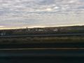
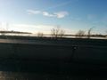
Following that, I headed for Seattle in deep fog. I wasn't in a deep fog, the roadway was. Well, that means I was too - at least until I drove out of it. For grins I snapped a few photos along the way, covering sunset plus one hour, plus two hours, etc. Those photos are below.
Photos
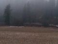
Latah creek @47.5755,-117.3905
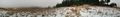
Pano at sunrise @47.5871,-117.4007
Sunrise + 1 hour
Sunrise + 2 hours @47.1042,-119.3559
Sunrise +3 hours @47.0075,-120.5713

Lunch panorama @47.0069,-120.5698
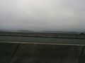
Another hour, another foggy lake. @47.5903,-122.2806


