Difference between revisions of "2015-01-21 49 8"
From Geohashing
imported>Q-Owl |
imported>FippeBot m (Location) |
||
| (3 intermediate revisions by 2 users not shown) | |||
| Line 23: | Line 23: | ||
Success: | Success: | ||
| − | * I drove to Bickenbach after our evening meal, arrived at about 19:45 | + | * I drove to Bickenbach after our evening meal, arrived at about 19:45 and found a place to park the car in the darkness near the "Erlensee", 400 m away from the hp. |
| − | + | * When I walked along the little creek "Landbach" in the darkness I heard some splashes. After switching on my torch there sat a nice big [[wikipedia:muskrat|muskrat]] (Bisam), which did not know, what to do now. I tried to take a photo with torch and smartphone. | |
| − | * When I walked along the little creek "Landbach" in the darkness I heard some splashes. | + | * After this I tried to reach the hp. It was very swampy there and the groundwater level was very high. Good to find the hp at a dry place. :-) |
| − | + | * I took a photo near the hash and of me, smiled, walked back to the car and drove home. | |
| − | |||
| − | * After this I tried to reach the hp. It was very swampy there and the groundwater level was very high. | ||
| − | |||
| − | * I took a photo near the hash and of me, | ||
| − | |||
| − | |||
== Photos == | == Photos == | ||
| Line 70: | Line 64: | ||
| latitude = 49 | | latitude = 49 | ||
| longitude = 8 | | longitude = 8 | ||
| − | | date = | + | | date = 2015-01-20 |
| name = [[User:Q-Owl|Q-Owl]] | | name = [[User:Q-Owl|Q-Owl]] | ||
| image = image name (optional) | | image = image name (optional) | ||
| Line 79: | Line 73: | ||
[[Category:Coordinates reached]] | [[Category:Coordinates reached]] | ||
[[Category:Expeditions with photos]] | [[Category:Expeditions with photos]] | ||
| + | {{location|DE|HE|DA}} | ||
Latest revision as of 02:31, 15 August 2019

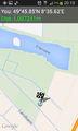
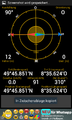
| Wed 21 Jan 2015 in 49,8: 49.7641988, 8.5937417 geohashing.info google osm bing/os kml crox |
Location
On a little meadow west of Bickenbach; not far from yesterdays hashpoint.
Participants
Plan
Todays hashpoint is not far from home and from yesterdays hashpoint. So I plan:
- Do a little detour on the way home.
- Drive to Bickenbach.
- Arrive about 17:00 19:15.
- Reach the hash point.
- Return home.
Expedition
Success:
- I drove to Bickenbach after our evening meal, arrived at about 19:45 and found a place to park the car in the darkness near the "Erlensee", 400 m away from the hp.
- When I walked along the little creek "Landbach" in the darkness I heard some splashes. After switching on my torch there sat a nice big muskrat (Bisam), which did not know, what to do now. I tried to take a photo with torch and smartphone.
- After this I tried to reach the hp. It was very swampy there and the groundwater level was very high. Good to find the hp at a dry place. :-)
- I took a photo near the hash and of me, smiled, walked back to the car and drove home.
Photos
Proof 1
Proof 2
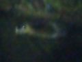
Muskrat at the Landbach
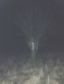
Little tree near the hashpoint
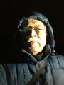
Smile in the dark


Achievements
Q-Owl earned the Land geohash achievement
|
Q-Owl earned the Consecutive geohash achievement
|