Difference between revisions of "2015-02-04 43 -116"
From Geohashing
imported>Eldin m (fix missing }} at end of template) |
imported>Eldin (add pictures) |
||
| Line 24: | Line 24: | ||
[[User:Eldin|Eldin]] | [[User:Eldin|Eldin]] | ||
| − | |||
| − | |||
== Expedition == | == Expedition == | ||
| Line 37: | Line 35: | ||
--> | --> | ||
<gallery perrow="5"> | <gallery perrow="5"> | ||
| + | Image:2015-02-04 43 -116 grin.jpg | The geohasher. | ||
| + | Image:2015-02-04 43 -116 hashpoint.jpg | The hashpoint. | ||
| + | Image:2015-02-04 43 -116 proof.jpg | Evidence that I was at the place. | ||
</gallery> | </gallery> | ||
| Line 43: | Line 44: | ||
{{land geohash| latitude = 43| longitude = -116| date = 2015-02-04| name = [[User:Eldin|Eldin]]}} | {{land geohash| latitude = 43| longitude = -116| date = 2015-02-04| name = [[User:Eldin|Eldin]]}} | ||
| − | |||
| − | |||
| − | |||
| − | |||
| − | |||
| − | |||
| − | |||
| − | |||
| − | |||
| − | |||
[[Category:Expeditions]] | [[Category:Expeditions]] | ||
| − | |||
[[Category:Expeditions with photos]] | [[Category:Expeditions with photos]] | ||
| − | |||
| − | |||
| − | |||
| − | |||
| − | |||
[[Category:Coordinates reached]] | [[Category:Coordinates reached]] | ||
| − | |||
| − | |||
| − | |||
| − | |||
| − | |||
| − | |||
| − | |||
| − | |||
| − | |||
| − | |||
| − | |||
| − | |||
| − | |||
| − | |||
| − | |||
| − | |||
| − | |||
| − | |||
Revision as of 17:54, 5 February 2015
| Wed 4 Feb 2015 in 43,-116: 43.6086366, -116.3727021 geohashing.info google osm bing/os kml crox |
Location
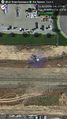
In a ditch by the railroad tracks, between Nola Ln and Locust Grove Rd
Participants
Expedition
As usual, I checked the hash location before I left work for the day. And this one was too easily reachable to ignore. The expedition itself was fairly unremarkable. I parked my car in the cul-de-sac on Nola Ln, less than 200ft from the hashpoint. From there it was just a short walk through the mud to reach the hash, which was on the edge of a (fortunately empty) ditch.
Photos

The geohasher.

The hashpoint.
Evidence that I was at the place.


Achievements
Eldin earned the Land geohash achievement
|