Difference between revisions of "2015-02-12 -35 149"
From Geohashing
imported>1PE |
imported>FippeBot m (Location) |
||
| (5 intermediate revisions by 2 users not shown) | |||
| Line 23: | Line 23: | ||
<!-- who attended: If you link to your wiki user name in this section, your expedition will be picked up by the various statistics generated for geohashing. You may use three tildes ~ as a shortcut to automatically insert the user signature of the account you are editing with. | <!-- who attended: If you link to your wiki user name in this section, your expedition will be picked up by the various statistics generated for geohashing. You may use three tildes ~ as a shortcut to automatically insert the user signature of the account you are editing with. | ||
--> | --> | ||
| + | ===[[User:1PE|1PE]]=== | ||
== Plans == | == Plans == | ||
| Line 29: | Line 30: | ||
== Expedition == | == Expedition == | ||
| − | + | I drove down during my lunch time. The hash turned out to be beside the ant hill that's adjacent to the nearest tree. | |
| + | |||
| + | NOTE: I put a copy of the expedition page in the bark of the tree. | ||
== Tracklog == | == Tracklog == | ||
| Line 38: | Line 41: | ||
Image:2012-##-## ## ## Alpha.jpg | Witty Comment | Image:2012-##-## ## ## Alpha.jpg | Witty Comment | ||
--> | --> | ||
| + | |||
<gallery perrow="5"> | <gallery perrow="5"> | ||
| + | Image:2015-02-12 -35 149 13.28.14.jpg|The general site, with the tree and the ant hill. Hash is right of the... | ||
| + | Image:2015-02-12_-35_149_13.27.33.jpg|ant hill... | ||
| + | Image:2015-02-12_-35_149_13.25.04.jpg|where I am pointing... | ||
| + | Image:2015-02-12_-35_149_13.26.11.jpg|or there, in the reverse pic... | ||
</gallery> | </gallery> | ||
| Line 46: | Line 54: | ||
| − | <!-- =============== USEFUL CATEGORIES FOLLOW ================ | + | <!-- =============== USEFUL CATEGORIES FOLLOW ================ --> |
| − | + | [[Category:Expeditions]] | |
| − | [[Category: | + | [[Category:Expeditions with photos]] |
| + | [[Category:Coordinates reached]] | ||
| + | [[Category:Expedition without GPS]] | ||
<!-- ==REQUEST FOR TWITTER BOT== Please leave either the New report or the Expedition planning category in as long as you work on it. This helps the twitter bot a lot with announcing the right outcome at the right moment. --> | <!-- ==REQUEST FOR TWITTER BOT== Please leave either the New report or the Expedition planning category in as long as you work on it. This helps the twitter bot a lot with announcing the right outcome at the right moment. --> | ||
<!-- Potential categories. Please include all the ones appropriate to your expedition --> | <!-- Potential categories. Please include all the ones appropriate to your expedition --> | ||
| − | |||
| − | |||
| − | |||
<!-- An actual expedition: | <!-- An actual expedition: | ||
[[Category:Expeditions]] | [[Category:Expeditions]] | ||
-- and one or more of -- | -- and one or more of -- | ||
| − | + | ||
[[Category:Expeditions with videos]] | [[Category:Expeditions with videos]] | ||
| − | + | ||
--> | --> | ||
<!-- if you reached your coords: | <!-- if you reached your coords: | ||
| − | + | ||
| Line 85: | Line 92: | ||
(Don't forget to delete this final close comment marker) --> | (Don't forget to delete this final close comment marker) --> | ||
| + | {{location|AU|ACT}} | ||
Latest revision as of 02:41, 15 August 2019
| Thu 12 Feb 2015 in -35,149: -35.3771296, 149.0997762 geohashing.info google osm bing/os kml crox |
Location
Beside a suburban road in Farrar ACT, at a grass/wooded parkland.
Participants
1PE
Plans
1PE
A lunchtime excursion from work.
Expedition
I drove down during my lunch time. The hash turned out to be beside the ant hill that's adjacent to the nearest tree.
NOTE: I put a copy of the expedition page in the bark of the tree.
Tracklog
Photos
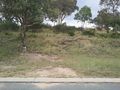
The general site, with the tree and the ant hill. Hash is right of the...
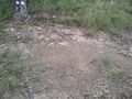
ant hill...
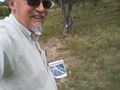
where I am pointing...
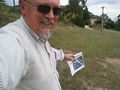
or there, in the reverse pic...


