Difference between revisions of "2015-02-26 52 1"
From Geohashing
imported>Sourcerer m ([live] Arrived.) |
imported>Sourcerer m ([live picture] Proof. [http://www.openstreetmap.org/?lat=52.73131728&lon=1.47127748&zoom=16&layers=B000FTF @52.7313,1.4713]) |
||
| Line 22: | Line 22: | ||
<gallery perrow="5"> | <gallery perrow="5"> | ||
| + | |||
| + | Image:2015-02-26_52_1_Sourcerer_1424987551344.jpg | Proof. [http://www.openstreetmap.org/?lat=52.73131728&lon=1.47127748&zoom=16&layers=B000FTF @52.7313,1.4713] | ||
</gallery> | </gallery> | ||
Revision as of 21:54, 26 February 2015
| Thu 26 Feb 2015 in 52,1: 52.7313236, 1.4712510 geohashing.info google osm bing/os kml crox |
Location
In a field close to a public path south of Neatishead, Norfolk, UK.
Participants
Expedition
Planning the first of two spanning midnight: 2015-02-26 52 1 :: 2015-02-27 52 0
- Arrived. -- Sourcerer (talk) @52.7313,1.4713 21:53, 26 February 2015 (GMT)
Photos
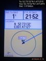
Proof. @52.7313,1.4713

Achievements
Other geohashing expeditions on the same day
Expeditions and Plans
| 2015-02-26 | ||
|---|---|---|
| Norwich, United Kingdom | Sourcerer | In a field close to a public path south of Neatishead, Norfolk, UK. |
| Enschede, Netherlands | Tchakkazulu | located on Crerarstraat in Hoogeveen. |