Difference between revisions of "2015-02-27 -6 106"
imported>ARizqiP |
imported>FippeBot m (Location) |
||
| (2 intermediate revisions by one other user not shown) | |||
| Line 23: | Line 23: | ||
At 1:45pm, I set off, again, from my college, Faculty of Computer Science, University of Indonesia, while it was about to rain. And just when I reached the train station, it rained. | At 1:45pm, I set off, again, from my college, Faculty of Computer Science, University of Indonesia, while it was about to rain. And just when I reached the train station, it rained. | ||
| − | After two train ride, 1 [http://en.wikipedia.org/wiki/Share_taxi#Angkot | + | After two train ride, 1 [http://en.wikipedia.org/wiki/Share_taxi#Angkot angkot] ride, and a little walk (took the wrong line of the two available in front of the station; it made a U-turn 150m before the hash), I arrived at the crossroad at 3:10pm. After some minutes prepping my phone at the sidewalk (including taking some preview pics), I crossed the road while taking video from my phone to ensure I can get a shot of my feet on the hash. Walk-by! Since I think I can't take any more pics, I headed back right away, with the right ''angkot''. |
== Photos == | == Photos == | ||
| Line 29: | Line 29: | ||
Image:2012-##-## ## ## Alpha.jpg | Witty Comment | Image:2012-##-## ## ## Alpha.jpg | Witty Comment | ||
--> | --> | ||
| − | <gallery | + | <gallery> |
| + | Image:20150227 141617 -6 106.jpg | Taking a train to the hash | ||
| + | Image:Screenshot 2015-02-27-15-11-04.png | This screenshot was taken before crossing. Actual taker's location is on the dot. | ||
| + | Image:20150227 151208 -6 106.jpg | The hash points to that grass patch over there. | ||
| + | Image:VID 20150227 151314.3gp snapshot 00.32 2015.02.27 19.49.14.jpg | First step on the hash (Note: May be off by several feet) | ||
| + | Image:VID 20150227 151314.3gp snapshot 00.42 -2015.02.27 19.55.21-.jpg | Self-shot after crossing | ||
| + | Image:20150227 152246 -6 106.jpg | The right ''angkot'' taken on way back. | ||
</gallery> | </gallery> | ||
| Line 56: | Line 62: | ||
[[Category:Expeditions]] | [[Category:Expeditions]] | ||
[[Category:Coordinates reached]] | [[Category:Coordinates reached]] | ||
| + | {{location|ID|JW|JK}} | ||
Latest revision as of 02:52, 15 August 2019
| Fri 27 Feb 2015 in -6,106: -6.2028909, 106.9041980 geohashing.info google osm bing/os kml crox |
Location
Crossroad of Jl. Jatinegara Kaum and Jl. Bekasi Timur Raya, East Jakarta.
Participants
Plans
At 10am, while in class, I checked the hash for today and (again) got surprised (still able to keep low). There were two reasons:
- After some months, it points to an area "in my reach" (1km north of a commuter train station) while I can have some time to venture out.
- On the satellite image, the point is right in the middle of a street, on a crossroad, at its pedestrian crossing. Now that is a hash to get.
Expedition
At 1:45pm, I set off, again, from my college, Faculty of Computer Science, University of Indonesia, while it was about to rain. And just when I reached the train station, it rained.
After two train ride, 1 angkot ride, and a little walk (took the wrong line of the two available in front of the station; it made a U-turn 150m before the hash), I arrived at the crossroad at 3:10pm. After some minutes prepping my phone at the sidewalk (including taking some preview pics), I crossed the road while taking video from my phone to ensure I can get a shot of my feet on the hash. Walk-by! Since I think I can't take any more pics, I headed back right away, with the right angkot.
Photos

Taking a train to the hash
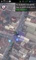
This screenshot was taken before crossing. Actual taker's location is on the dot.
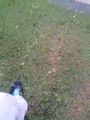
The hash points to that grass patch over there.
First step on the hash (Note: May be off by several feet)

Self-shot after crossing
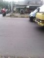
The right angkot taken on way back.


Achievements
ARizqiP earned the Land geohash achievement
|
ARizqiP earned the Public transport geohash achievement
|