Difference between revisions of "2015-03-10 49 8"
From Geohashing
imported>Q-Owl (Created page with "<!-- thumb|left|Hashpoint --> {{meetup graticule | lat=49 | lon=8 | date=2015-10-03 }}__NOTOC__ == Location == In the wikipedia:Odenwal...") |
imported>Q-Owl |
||
| Line 21: | Line 21: | ||
== Expedition == | == Expedition == | ||
| − | |||
| − | |||
| − | |||
| − | + | I drove home after work and drove together with my wife to the forest road between [http://de.wikipedia.org/wiki/Hambach_%28Heppenheim%29 Hambach] and [http://de.wikipedia.org/wiki/Schannenbach Schannenbach]. It was very foggy there here and we saw remaining snow on the meadow north of the road. | |
| − | + | ||
| + | We parked the car, went a few hundred meters and found the hashpoint (and a nice place to hide a geocache) after a short dance. | ||
| + | The tree near the hashpoint was marked already - presumably for logging. | ||
| + | Taking of photos and a quick return to the car in the beginng rain. | ||
| + | |||
== Photos == | == Photos == | ||
<!-- Insert pictures between the gallery tags using the following format: | <!-- Insert pictures between the gallery tags using the following format: | ||
Image:2014-##-## ## ## Alpha.jpg | Witty Comment | Image:2014-##-## ## ## Alpha.jpg | Witty Comment | ||
--> | --> | ||
| − | + | ||
<gallery perrow="5" > | <gallery perrow="5" > | ||
| − | |||
Image:2015-03-10 49 8 proof.png | Proof | Image:2015-03-10 49 8 proof.png | Proof | ||
| − | |||
Image:2015-03-10 49 8 north.jpg | North | Image:2015-03-10 49 8 north.jpg | North | ||
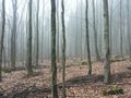
| − | Image:2015-03-10 49 8 east.jpg | East | + | Image:2015-03-10 49 8 east.jpg | East |
Image:2015-03-10 49 8 south.jpg | South | Image:2015-03-10 49 8 south.jpg | South | ||
| − | Image:2015-03-10 49 8 grin.jpg | Happy grin² | + | Image:2015-03-10 49 8 west.jpg | West |
| + | Image:2015-03-10 49 8 grin.jpg | Happy grin² and marked tree | ||
</gallery> | </gallery> | ||
| − | + | ||
<!-- | <!-- | ||
List of uploaded Files: | List of uploaded Files: | ||
Revision as of 18:56, 10 March 2015
| Sat 3 Oct 2015 in 49,8: 49.9958764, 8.4999272 geohashing.info google osm bing/os kml crox |
Location
In the Odenwald between Hambach and Schannenbach.
Participants
- Q-Owl
- Q-Owla
Plan
Drive by car to the hash area after work and walk to the hashpoint.
Expedition
I drove home after work and drove together with my wife to the forest road between Hambach and Schannenbach. It was very foggy there here and we saw remaining snow on the meadow north of the road.
We parked the car, went a few hundred meters and found the hashpoint (and a nice place to hide a geocache) after a short dance. The tree near the hashpoint was marked already - presumably for logging. Taking of photos and a quick return to the car in the beginng rain.
Photos
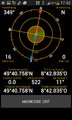
Proof
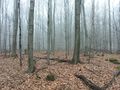
North

East
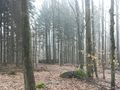
South
West

Happy grin² and marked tree


Achievements / Honorable Mention
Q-Owl earned the Land geohash achievement
|