Difference between revisions of "2015-03-10 49 8"
imported>Q-Owl m (→Expedition) |
imported>Q-Owl |
||
| Line 60: | Line 60: | ||
| name = Q-Owl | | name = Q-Owl | ||
}} | }} | ||
| − | + | <!-- | |
| − | |||
Have I really been the only one? | Have I really been the only one? | ||
{{Last man standing | {{Last man standing | ||
| Line 69: | Line 68: | ||
| name = [[User:Q-Owl|Q-Owl]] | | name = [[User:Q-Owl|Q-Owl]] | ||
}} | }} | ||
| − | |||
== Other Geohashing Expeditions and Plans on This Day == | == Other Geohashing Expeditions and Plans on This Day == | ||
{{expedition summaries|2015-03-10}} | {{expedition summaries|2015-03-10}} | ||
| − | + | --> | |
| − | |||
<!-- =============== USEFUL CATEGORIES FOLLOW ================ --> | <!-- =============== USEFUL CATEGORIES FOLLOW ================ --> | ||
Revision as of 22:43, 10 March 2015

| Tue 10 Mar 2015 in 49,8: 49.6793148, 8.7139266 geohashing.info google osm bing/os kml crox |
Location
In the Odenwald between Hambach and Schannenbach.
Participants
- Q-Owl
- Q-Owla
Plan
Drive by car to the hash area after work and walk to the hashpoint.
Expedition
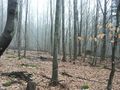
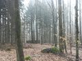
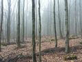
I drove home after work and drove together with my wife to the forest road between Hambach and Schannenbach. It was very foggy there here and we saw remaining snow on the meadow north of the road.
We parked the car, walked a few hundred meters and found the hashpoint (and a nice place to hide a geocache) after a short dance. The tree near the hashpoint was marked already - presumably for logging. Taking of photos and a quick return to the car in the beginng rain.
Edit:
There are Problems with the coordinates today.
I hope the coordinates, my smartphone displayed, are the right ones.
Photos
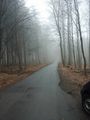
Forest road view east
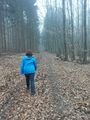
Walk to the hashpoint
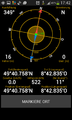
Proof
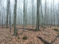
North
East
South
West
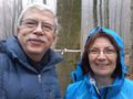
Happy grin² and marked tree


Achievements / Honorable Mention
Q-Owl earned the Land geohash achievement
|