Difference between revisions of "2015-03-15 60 24"
imported>Nebini (Template) |
imported>FippeBot m (Location) |
||
| (2 intermediate revisions by one other user not shown) | |||
| Line 18: | Line 18: | ||
__NOTOC__ | __NOTOC__ | ||
== Location == | == Location == | ||
| − | + | On a field with strange patterns might be a strawberry field. Near Peuramaa golf, Kirkkonummi, Finland. | |
== Participants == | == Participants == | ||
| − | + | * [[User:Nebini|Nebini]] | |
| − | |||
== Plans == | == Plans == | ||
| − | + | Nebini's plans: If the weather is good then take bicycle, camera, gps and go for a trip. | |
== Expedition == | == Expedition == | ||
| − | + | After waking up to a lazy sunday I decided to try taking my bicycle to a local train for the first time and to save over 20 kilometers of cycling on the way to the hash. It took about 25 minutes to reach the Espoo's main train station and little more than 10 minutes to reach Kirkkonummi. | |
| − | + | After leaving the train and cycling about 2 kilometers the batteries on GPS-device ran out thus I had to take a detour back to buy new batteries. The previous set of premium batteries had lasted 7 years in that device! After buying 4 cheapest alkaline double A batteries for 1,99€ the journey continued. Since the general area is somewhat familiar I didn't do any planning. Only note was to turn off the main road when the GPS points heavily to the left. | |
| − | |||
| − | + | So I should have turned before reaching Eestinkylä but that I didn't know at the time. That shop which I passed by for n'th time is in Eestinkylä. Before turning of the main road there were some patches of the old road which had been in use before the first world war. After turning off from the big road the smaller road/path went through an abandoned courtyard which had some still standing and collapsed buildings. | |
| − | |||
| − | |||
| − | |||
| − | |||
| − | |||
| − | + | Forest was also different than usual. Tamarack trees and old oak trees were plentiful. Normally evergreens and birch are the standard trees. After crossing a hay field and startling a pack of white tailed deers I arrived near the hashpoint. The end of the read was a parking place for a nearby tower used by bird watchers and the field was just a normal field. Reaching the hash was easy, the field was not planted and dry. On the parking lot I accidentally found and logged a geocache. | |
| − | |||
| − | |||
| + | The trip back to Espoo followed a more straightforward route. It was getting dark. After reaching Peuramaa lights were necessary to continue cycling at reasonable speed. The shortcut after Tolsa was not a vise choice at this time of the year. The access road was still partly covered with snow and partly frozen puddles. | ||
| − | + | [[Image:2015-03-15_60_24_route.png|thumb|Approximate track taken during this expedition]] | |
| − | |||
| − | |||
| − | + | == Photos == | |
| + | <gallery perrow="5"> | ||
| + | Image:2015-03-15_60_24_railway.JPG | Waiting for the train | ||
| + | Image:2015-03-15_60_24_Anemone_hepatica.JPG | First flowers | ||
| + | Image:2015-03-15_60_24_parking.JPG | Plenty of parking space | ||
| + | Image:2015-03-15_60_24_hash.JPG | At the hash | ||
| + | Image:2015-03-15_60_24_ruins.JPG | One of multiple old building encountered on the trip | ||
| + | </gallery> | ||
| − | + | == Déjà-vu's == | |
| − | + | Following places were seen again on this trip. No significant changes were apparent to casual observer. | |
| − | + | <gallery perrow="5"> | |
| − | --> | + | Image:2013-06-29_60_24_shop.jpeg |
| + | Image:2014-08-22_60_24_deers_1.jpg | ||
| + | Image:2014-09-21_60_24_No_motor_vehicles.JPG | ||
| + | </gallery> | ||
| − | |||
[[Category:Expeditions]] | [[Category:Expeditions]] | ||
| − | |||
[[Category:Expeditions with photos]] | [[Category:Expeditions with photos]] | ||
| − | |||
| − | |||
| − | |||
| − | |||
[[Category:Coordinates reached]] | [[Category:Coordinates reached]] | ||
| − | + | {{location|FI|18}} | |
| − | |||
| − | |||
| − | |||
| − | |||
| − | |||
| − | |||
| − | |||
| − | |||
| − | |||
| − | |||
| − | |||
| − | |||
| − | |||
| − | |||
| − | |||
| − | |||
| − | |||
Latest revision as of 03:02, 15 August 2019
| Sun 15 Mar 2015 in 60,24: 60.0847603, 24.4831429 geohashing.info google osm bing/os kml crox |
Location
On a field with strange patterns might be a strawberry field. Near Peuramaa golf, Kirkkonummi, Finland.
Participants
Plans
Nebini's plans: If the weather is good then take bicycle, camera, gps and go for a trip.
Expedition
After waking up to a lazy sunday I decided to try taking my bicycle to a local train for the first time and to save over 20 kilometers of cycling on the way to the hash. It took about 25 minutes to reach the Espoo's main train station and little more than 10 minutes to reach Kirkkonummi.
After leaving the train and cycling about 2 kilometers the batteries on GPS-device ran out thus I had to take a detour back to buy new batteries. The previous set of premium batteries had lasted 7 years in that device! After buying 4 cheapest alkaline double A batteries for 1,99€ the journey continued. Since the general area is somewhat familiar I didn't do any planning. Only note was to turn off the main road when the GPS points heavily to the left.
So I should have turned before reaching Eestinkylä but that I didn't know at the time. That shop which I passed by for n'th time is in Eestinkylä. Before turning of the main road there were some patches of the old road which had been in use before the first world war. After turning off from the big road the smaller road/path went through an abandoned courtyard which had some still standing and collapsed buildings.
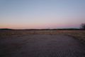
Forest was also different than usual. Tamarack trees and old oak trees were plentiful. Normally evergreens and birch are the standard trees. After crossing a hay field and startling a pack of white tailed deers I arrived near the hashpoint. The end of the read was a parking place for a nearby tower used by bird watchers and the field was just a normal field. Reaching the hash was easy, the field was not planted and dry. On the parking lot I accidentally found and logged a geocache.
The trip back to Espoo followed a more straightforward route. It was getting dark. After reaching Peuramaa lights were necessary to continue cycling at reasonable speed. The shortcut after Tolsa was not a vise choice at this time of the year. The access road was still partly covered with snow and partly frozen puddles.

Photos
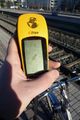
Waiting for the train
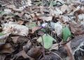
First flowers
Plenty of parking space
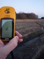
At the hash
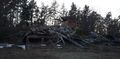
One of multiple old building encountered on the trip


Déjà-vu's
Following places were seen again on this trip. No significant changes were apparent to casual observer.


