Difference between revisions of "2015-03-22 34 -118"
imported>Thomcat (Success, remove new report category) |
imported>Bravissimo594 (Added description of expedition) |
||
| Line 18: | Line 18: | ||
__NOTOC__ | __NOTOC__ | ||
== Location == | == Location == | ||
| − | + | The hash is in the middle of the bus-lane exit from eastbound Interstate Highway 10 to Del Mar Avenue in Rosemead. | |
== Participants == | == Participants == | ||
<!-- who attended: If you link to your wiki user name in this section, your expedition will be picked up by the various statistics generated for geohashing. You may use three tildes ~ as a shortcut to automatically insert the user signature of the account you are editing with. | <!-- who attended: If you link to your wiki user name in this section, your expedition will be picked up by the various statistics generated for geohashing. You may use three tildes ~ as a shortcut to automatically insert the user signature of the account you are editing with. | ||
--> | --> | ||
| + | * [[User:Bravissimo594|Bravissimo594]] ([[User talk:Bravissimo594|talk]]) | ||
| + | * The Bus Driver | ||
== Plans == | == Plans == | ||
| Line 30: | Line 32: | ||
== Expedition == | == Expedition == | ||
<!-- how it all turned out. your narrative goes here. --> | <!-- how it all turned out. your narrative goes here. --> | ||
| + | I made a loop from Pasadena to Los Angeles Union Station by way of the Gold Line and then back up to Pasadena on Bus Line 487, which passes through the day's hashpoint. At Union Station, it took a bit of a search and some question-asking to find out where to catch Metro Bus 487. The lines that use the El Monte Busway do not pull into Union Station at all; passengers board at the on-ramp from Alameda St. I got to that stop with plenty of time to spare before the 9:21pm bus arrived and got to watch one or two other lines load up before #487 arrived on schedule. I was the only one to join the driver on this last run of the night for this bus, and no one joined us at either the stop for LAC-USC Medical Center nor at the Cal State LA stop. | ||
| + | So only the bus driver and I zoomed through the hashpoint on the exit from the Busway to Del Mar Avenue. We then followed surface streets for the half-hour route to Sierra Madre Villa Station in Pasadena. The driver seemed a bit confused as to why I would take his bus from Union Station to Sierra Madre Villa Station when the Metro light-rail Gold Line could get me there so much faster. So as not to distract him from his driving, I did not explain geohashing to him but instead told him that I just wanted to make a big loop. | ||
| − | == Tracklog == | + | An older couple boarded the bus as I left, so the driver had company for the rest of his trip. -- [[User:Bravissimo594|Bravissimo594]] ([[User talk:Bravissimo594|talk]]) |
| − | + | ||
| + | <!-- == Tracklog == | ||
| + | if your GPS device keeps a log, you may post a link here --> | ||
== Photos == | == Photos == | ||
| Line 40: | Line 46: | ||
--> | --> | ||
<gallery perrow="5"> | <gallery perrow="5"> | ||
| + | |||
| + | Image:2015-03-22_34_-118_Bravissimo594_1427083083180.jpg | Union Station before heading out to the El Monte bus lanes. [http://www.openstreetmap.org/?lat=34.05600000&lon=-118.23600000&zoom=16&layers=B000FTF @34.0560,-118.2360] | ||
| + | |||
| + | Image:2015-03-22_34_-118_Bravissimo594_1427083815107.jpg | Ready to wait now. [http://www.openstreetmap.org/?lat=34.05440000&lon=-118.23700000&zoom=16&layers=B000FTF @34.0544,-118.2370] | ||
| + | |||
| + | Image:2015-03-22_34_-118_Bravissimo594_1427084378882.jpg | Empty bus seats ahead of me. Busy freeway to the right on the way to the hash point. [http://www.openstreetmap.org/?lat=34.05430000&lon=-118.23600000&zoom=16&layers=B000FTF @34.0543,-118.2360] | ||
Image:2015-03-22_34_-118_Bravissimo594_1427085039000.jpg | Geohash Droid just passing the hash point on Metro bus line 487. [http://www.openstreetmap.org/?lat=34.07566852&lon=-118.09958431&zoom=16&layers=B000FTF @34.0757,-118.0996] | Image:2015-03-22_34_-118_Bravissimo594_1427085039000.jpg | Geohash Droid just passing the hash point on Metro bus line 487. [http://www.openstreetmap.org/?lat=34.07566852&lon=-118.09958431&zoom=16&layers=B000FTF @34.0757,-118.0996] | ||
| − | Image:2015-03-22_34_-118_Bravissimo594_1427085052652.jpg | | + | Image:2015-03-22_34_-118_Bravissimo594_1427085052652.jpg | Only me ... and the driver. [http://www.openstreetmap.org/?lat=34.07200000&lon=-118.10300000&zoom=16&layers=B000FTF @34.0720,-118.1030] |
| − | |||
| − | |||
| − | |||
</gallery> | </gallery> | ||
| Line 55: | Line 64: | ||
{{#vardefine:ribbonwidth|800px}} | {{#vardefine:ribbonwidth|800px}} | ||
<!-- Add any achievement ribbons you earned below, or remove this section --> | <!-- Add any achievement ribbons you earned below, or remove this section --> | ||
| + | Though I logged many miles on public transport, I did drive from my house to the origin of my trek, so I do not qualify for the [[Public transport geohash achievement]]. | ||
[[Category:Expeditions]] | [[Category:Expeditions]] | ||
[[Category:Expeditions with photos]] | [[Category:Expeditions with photos]] | ||
[[Category:Coordinates reached]] | [[Category:Coordinates reached]] | ||
Revision as of 22:27, 20 April 2015
| Sun 22 Mar 2015 in 34,-118: 34.0718751, -118.1057869 geohashing.info google osm bing/os kml crox |
Location
The hash is in the middle of the bus-lane exit from eastbound Interstate Highway 10 to Del Mar Avenue in Rosemead.
Participants
- Bravissimo594 (talk)
- The Bus Driver
Plans
- I plan to pass through the hash point on Metro bus line 487 that leaves Union Station at about 9:21pm. -- Bravissimo594 (talk) 23:05, 22 March 2015 (EDT)
Expedition
I made a loop from Pasadena to Los Angeles Union Station by way of the Gold Line and then back up to Pasadena on Bus Line 487, which passes through the day's hashpoint. At Union Station, it took a bit of a search and some question-asking to find out where to catch Metro Bus 487. The lines that use the El Monte Busway do not pull into Union Station at all; passengers board at the on-ramp from Alameda St. I got to that stop with plenty of time to spare before the 9:21pm bus arrived and got to watch one or two other lines load up before #487 arrived on schedule. I was the only one to join the driver on this last run of the night for this bus, and no one joined us at either the stop for LAC-USC Medical Center nor at the Cal State LA stop.
So only the bus driver and I zoomed through the hashpoint on the exit from the Busway to Del Mar Avenue. We then followed surface streets for the half-hour route to Sierra Madre Villa Station in Pasadena. The driver seemed a bit confused as to why I would take his bus from Union Station to Sierra Madre Villa Station when the Metro light-rail Gold Line could get me there so much faster. So as not to distract him from his driving, I did not explain geohashing to him but instead told him that I just wanted to make a big loop.
An older couple boarded the bus as I left, so the driver had company for the rest of his trip. -- Bravissimo594 (talk)
Photos
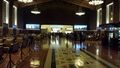
Union Station before heading out to the El Monte bus lanes. @34.0560,-118.2360
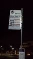
Ready to wait now. @34.0544,-118.2370
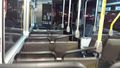
Empty bus seats ahead of me. Busy freeway to the right on the way to the hash point. @34.0543,-118.2360
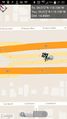
Geohash Droid just passing the hash point on Metro bus line 487. @34.0757,-118.0996
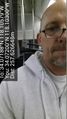
Only me ... and the driver. @34.0720,-118.1030


Achievements
Though I logged many miles on public transport, I did drive from my house to the origin of my trek, so I do not qualify for the Public transport geohash achievement.