Difference between revisions of "2015-05-13 37 -122"
imported>Codae (Created page with "{{subst:Expedition |lat = latitude of graticule |lon = longitude of graticule |date = date of expedition, in YYYY-MM-DD format }}") |
imported>FippeBot m (Location) |
||
| (2 intermediate revisions by one other user not shown) | |||
| Line 10: | Line 10: | ||
--> | --> | ||
{{meetup graticule | {{meetup graticule | ||
| − | | lat= | + | | lat=37 |
| − | | lon= | + | | lon=-122 |
| − | | date= | + | | date=2015-05-13 |
}} | }} | ||
| Line 19: | Line 19: | ||
== Location == | == Location == | ||
<!-- where you've surveyed the hash to be --> | <!-- where you've surveyed the hash to be --> | ||
| + | In a front garden in Oakland, California. | ||
== Participants == | == Participants == | ||
<!-- who attended: If you link to your wiki user name in this section, your expedition will be picked up by the various statistics generated for geohashing. You may use three tildes ~ as a shortcut to automatically insert the user signature of the account you are editing with. | <!-- who attended: If you link to your wiki user name in this section, your expedition will be picked up by the various statistics generated for geohashing. You may use three tildes ~ as a shortcut to automatically insert the user signature of the account you are editing with. | ||
--> | --> | ||
| + | [[User:Codae|Codae]] | ||
== Plans == | == Plans == | ||
<!-- what were the original plans --> | <!-- what were the original plans --> | ||
| + | Ride the bus to the vicinity, walk to the geohash, and then reverse. | ||
== Expedition == | == Expedition == | ||
<!-- how it all turned out. your narrative goes here. --> | <!-- how it all turned out. your narrative goes here. --> | ||
| + | The first mishap came when I mistook Interstate 580 for State Highway 13 and got off the bus about a mile short of where I intended. I then had nothing to do but to continue, walking, up the hill until the next bus caught up to me. | ||
| + | |||
| + | The second mishap came after I exited the bus in the right neighborhood, when I mistook the road I planned to follow for a highway offramp and continued past it. A little backtracking corrected this error. | ||
| + | |||
| + | Then I made it to the hashpoint and took a bunch of photos, most of which failed to display the GPS screen readably owing to the high, bright sun. I eventually satisfied myself and left. Not entirely coincidentally, this was at about the time a confused-looking man came down the driveway to fill (or maybe move) the yard waste bin and started watching me silently. | ||
| + | |||
| + | On the way back, I used the same bus I had mistakenly exited earlier. I noticed this because its identification number was the memorable 1337. However, the bus itself was not very elite, having a partially nonfunctional status display that would inform riders of a pending "' REQUEST" upon a passenger's requesting a stop. | ||
| + | |||
| + | And then I finally got off the bus a few blocks before reaching home base for no good reason. | ||
== Tracklog == | == Tracklog == | ||
| Line 38: | Line 50: | ||
--> | --> | ||
<gallery perrow="5"> | <gallery perrow="5"> | ||
| + | Image:2015-05-13 37 -122 Hashpoint.JPG | The location of the geohash, featuring a walk up to the front door of the house just left of frame, a dark patch from which a small stream passes underground, and a backpack (for scale, or perhaps out of apathy as to its inclusion in the picture.) | ||
| + | Image:2015-05-13 37 -122 Proof.JPG | And, yes, this is the right spot. | ||
</gallery> | </gallery> | ||
| Line 43: | Line 57: | ||
{{#vardefine:ribbonwidth|800px}} | {{#vardefine:ribbonwidth|800px}} | ||
<!-- Add any achievement ribbons you earned below, or remove this section --> | <!-- Add any achievement ribbons you earned below, or remove this section --> | ||
| − | + | {{Land geohash|latitude=37|longitude=-122|date=2015-05-13|name=Codae}} | |
| + | {{Public transport geohash|latitude=37|longitude=-122|date=2015-05-13|name=Codae}} | ||
<!-- =============== USEFUL CATEGORIES FOLLOW ================ | <!-- =============== USEFUL CATEGORIES FOLLOW ================ | ||
Delete the next line ONLY if you have chosen the appropriate categories below. If you are unsure, don't worry. People will read your report and help you with the classification.--> | Delete the next line ONLY if you have chosen the appropriate categories below. If you are unsure, don't worry. People will read your report and help you with the classification.--> | ||
| − | + | ||
<!-- ==REQUEST FOR TWITTER BOT== Please leave either the New report or the Expedition planning category in as long as you work on it. This helps the twitter bot a lot with announcing the right outcome at the right moment. --> | <!-- ==REQUEST FOR TWITTER BOT== Please leave either the New report or the Expedition planning category in as long as you work on it. This helps the twitter bot a lot with announcing the right outcome at the right moment. --> | ||
| − | |||
| − | |||
| − | |||
| − | |||
| − | |||
[[Category:Expeditions]] | [[Category:Expeditions]] | ||
| − | + | ||
[[Category:Expeditions with photos]] | [[Category:Expeditions with photos]] | ||
| − | + | ||
| − | |||
| − | |||
| − | |||
| − | |||
[[Category:Coordinates reached]] | [[Category:Coordinates reached]] | ||
| − | + | {{location|US|CA|AA}} | |
| − | |||
| − | |||
| − | |||
| − | |||
| − | |||
| − | |||
| − | |||
| − | |||
| − | |||
| − | |||
| − | |||
| − | |||
| − | |||
| − | |||
| − | |||
| − | |||
| − | |||
Latest revision as of 03:36, 15 August 2019
| Wed 13 May 2015 in 37,-122: 37.7941752, -122.1811098 geohashing.info google osm bing/os kml crox |
Location
In a front garden in Oakland, California.
Participants
Plans
Ride the bus to the vicinity, walk to the geohash, and then reverse.
Expedition
The first mishap came when I mistook Interstate 580 for State Highway 13 and got off the bus about a mile short of where I intended. I then had nothing to do but to continue, walking, up the hill until the next bus caught up to me.
The second mishap came after I exited the bus in the right neighborhood, when I mistook the road I planned to follow for a highway offramp and continued past it. A little backtracking corrected this error.
Then I made it to the hashpoint and took a bunch of photos, most of which failed to display the GPS screen readably owing to the high, bright sun. I eventually satisfied myself and left. Not entirely coincidentally, this was at about the time a confused-looking man came down the driveway to fill (or maybe move) the yard waste bin and started watching me silently.
On the way back, I used the same bus I had mistakenly exited earlier. I noticed this because its identification number was the memorable 1337. However, the bus itself was not very elite, having a partially nonfunctional status display that would inform riders of a pending "' REQUEST" upon a passenger's requesting a stop.
And then I finally got off the bus a few blocks before reaching home base for no good reason.
Tracklog
Photos
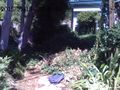
The location of the geohash, featuring a walk up to the front door of the house just left of frame, a dark patch from which a small stream passes underground, and a backpack (for scale, or perhaps out of apathy as to its inclusion in the picture.)
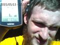
And, yes, this is the right spot.


Achievements
Codae earned the Land geohash achievement
|
Codae earned the Public transport geohash achievement
|