Difference between revisions of "2015-05-10 60 22"
imported>Nebini (Template) |
imported>FippeBot m (Location) |
||
| (One intermediate revision by one other user not shown) | |||
| Line 15: | Line 15: | ||
}} | }} | ||
| − | |||
__NOTOC__ | __NOTOC__ | ||
== Location == | == Location == | ||
| − | + | On a swamp, 16 km North from Turku Bus station. | |
== Participants == | == Participants == | ||
| − | + | * [[User:Nebini|Nebini]] | |
| − | |||
== Plans == | == Plans == | ||
| − | + | Take a short bicycle trip to the hashpoint while visiting relatives. | |
== Expedition == | == Expedition == | ||
| − | + | Nothing special to report. Typical countryside with uncountable small details. Attached pictures doesn't do justice to the multiple wonders ((glacial erratics, special trees) encountered on the expedition. | |
| + | |||
| + | Cycled the first 16 km's on pawed and gravel roads. As usual when getting near the point sane route planning was thrown out of equation. Carrying bicycle over Metsäsaari took some effort. The area near hashpoint was logged "recently". Point was in typical young forest which was littered with decaying logging tracks. It would have been possible to cycle for the whole trip. I decided to leave the bicycle behind and walk last 300 meters. | ||
| + | |||
| + | == Track == | ||
| + | |||
| + | [[Image:2015-05-10_60_22_route.png | 400px | Route taken to and]] | ||
| − | |||
| − | |||
== Photos == | == Photos == | ||
| − | |||
| − | |||
| − | |||
<gallery perrow="5"> | <gallery perrow="5"> | ||
| + | Image:2015-05-10_60_22_roadsign.jpg | Roadsign at the sourhernmost part of the expedition. | ||
| + | Image:2015-05-10_60_22_reached.JPG | The proof | ||
| + | Image:2015-05-10_60_22_horses.jpg | Curious horses | ||
| + | Image:2015-05-10_60_22_hives.jpg | Active beehives | ||
</gallery> | </gallery> | ||
| − | |||
| − | |||
| − | |||
| − | + | [[Category:Expeditions]] | |
| − | |||
| − | [[Category: | ||
| − | |||
| − | |||
| − | |||
| − | |||
| − | |||
| − | |||
| − | |||
| − | |||
| − | |||
| − | |||
| − | |||
| − | |||
| − | |||
| − | |||
| − | |||
| − | |||
[[Category:Coordinates reached]] | [[Category:Coordinates reached]] | ||
| − | + | {{location|FI|19}} | |
| − | |||
| − | |||
| − | |||
| − | |||
| − | |||
| − | |||
| − | |||
| − | |||
| − | |||
| − | |||
| − | |||
| − | |||
| − | |||
| − | |||
| − | |||
| − | |||
| − | |||
Latest revision as of 03:35, 15 August 2019
| Sun 10 May 2015 in 60,22: 60.6027466, 22.2611388 geohashing.info google osm bing/os kml crox |
Location
On a swamp, 16 km North from Turku Bus station.
Participants
Plans
Take a short bicycle trip to the hashpoint while visiting relatives.
Expedition
Nothing special to report. Typical countryside with uncountable small details. Attached pictures doesn't do justice to the multiple wonders ((glacial erratics, special trees) encountered on the expedition.
Cycled the first 16 km's on pawed and gravel roads. As usual when getting near the point sane route planning was thrown out of equation. Carrying bicycle over Metsäsaari took some effort. The area near hashpoint was logged "recently". Point was in typical young forest which was littered with decaying logging tracks. It would have been possible to cycle for the whole trip. I decided to leave the bicycle behind and walk last 300 meters.
Track

Photos
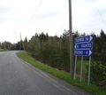
Roadsign at the sourhernmost part of the expedition.
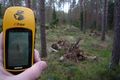
The proof
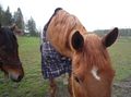
Curious horses
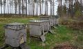
Active beehives


