Difference between revisions of "2015-06-01 53 -2"
From Geohashing
imported>Angel ([live picture] Again, close, but masses of cows running at once are a little scary. [http://www.openstreetmap.org/?lat=53.50380000&lon=-2.62894000&zoom=16&layers=B000FTF @53.5038,-2.6289]) |
imported>FippeBot m (Location) |
||
| (5 intermediate revisions by 2 users not shown) | |||
| Line 31: | Line 31: | ||
== Tracklog == | == Tracklog == | ||
| − | + | [https://www.endomondo.com/workouts/533626849/3871875 provided by Endomondo] | |
== Photos == | == Photos == | ||
| Line 48: | Line 48: | ||
Image:2015-06-01_53_-2_angel_1433161602530.jpg | Again, close, but masses of cows running at once are a little scary. [http://www.openstreetmap.org/?lat=53.50380000&lon=-2.62894000&zoom=16&layers=B000FTF @53.5038,-2.6289] | Image:2015-06-01_53_-2_angel_1433161602530.jpg | Again, close, but masses of cows running at once are a little scary. [http://www.openstreetmap.org/?lat=53.50380000&lon=-2.62894000&zoom=16&layers=B000FTF @53.5038,-2.6289] | ||
| + | |||
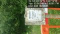
| + | Image:2015-06-01_53_-2_angel_1433162001000.jpg | Looks like some kind of nature reserve; keep to the paths. Without a proper map, I'll have to follow every path to see how close I can get [http://www.openstreetmap.org/?lat=53.50256673&lon=-2.62923105&zoom=16&layers=B000FTF @53.5026,-2.6292] | ||
| + | |||
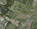
| + | Image:2015-06-01_53_-2_angel_1433162470863.jpg | Abort mission? Or try for access from the south? [http://www.openstreetmap.org/?lat=53.50140000&lon=-2.62911000&zoom=16&layers=B000FTF @53.5014,-2.6291] | ||
| + | |||
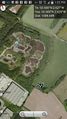
| + | Image:2015-06-01 53 -2 Coordinates.jpg | Coordinates of the photos. 180 metres to the closest. | ||
</gallery> | </gallery> | ||
== Achievements == | == Achievements == | ||
{{#vardefine:ribbonwidth|800px}} | {{#vardefine:ribbonwidth|800px}} | ||
| − | |||
| − | |||
| − | |||
| − | |||
| − | |||
| − | |||
| − | |||
| − | |||
| − | |||
| − | |||
| − | |||
| − | |||
| − | |||
| − | |||
[[Category:Expeditions]] | [[Category:Expeditions]] | ||
| − | |||
[[Category:Expeditions with photos]] | [[Category:Expeditions with photos]] | ||
| − | + | [[Category:Coordinates not reached]] | |
| − | |||
| − | |||
| − | |||
| − | |||
| − | [[Category:Coordinates reached]] | ||
| − | + | <!-- impassible crowd of cows on one side, footpath closed on the other --> | |
| − | |||
| − | |||
| − | -- | ||
| − | |||
[[Category:Not reached - Mother Nature]] | [[Category:Not reached - Mother Nature]] | ||
| − | |||
| − | |||
[[Category:Not reached - No public access]] | [[Category:Not reached - No public access]] | ||
| − | + | {{location|GB|ENG|WGN}} | |
| − | |||
| − | |||
| − | |||
| − | |||
| − | |||
| − | |||
| − | |||
Latest revision as of 03:52, 15 August 2019
| Mon 1 Jun 2015 in 53,-2: 53.5001180, -2.6271177 geohashing.info google osm bing/os kml crox |
Location
- Looks like this is near to both Three Sisters and Viridor Wood. Not sure if it'll be accessible, but worth a try.
Participants
Plans
- I'm staying with my mum for the weekend, and she says she passes Viridor Wood on the way to work. It's only about 8 miles back along the canal, so I should be able to walk home if she drops me off on the way.
Expedition
- Day's first problem: diarrhea and cramps. Putting off the expedition until the afternoon, in the hope I'll feel better by then. Fingers crossed.
Tracklog
Photos
Viridor Wood… the hash must be in this rough direction. @53.5018,-2.6146
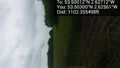
It's a path, and it's pointing in the right direction… @53.5040,-2.6239
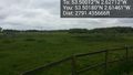
Far side of this field, can't be too hard? @53.5030,-2.6256
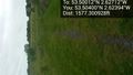
Or… maybe not. @53.5030,-2.6256
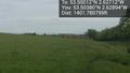
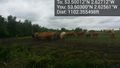
Again, close, but masses of cows running at once are a little scary. @53.5038,-2.6289
Looks like some kind of nature reserve; keep to the paths. Without a proper map, I'll have to follow every path to see how close I can get @53.5026,-2.6292
Abort mission? Or try for access from the south? @53.5014,-2.6291
Coordinates of the photos. 180 metres to the closest.


