Difference between revisions of "2015-05-31 51 -2"
imported>Geeoharee |
imported>Geeoharee |
||
| Line 19: | Line 19: | ||
== Expedition == | == Expedition == | ||
| − | |||
| − | + | An uneventful drive from Cirencester towards South Wales, noting the 'Welcome to Wales' sign by the side of the road but unable to photograph it while driving. In lieu of that, I stopped in a supermarket car park and photographed one of the bilingual signs - proof I wasn't in England any more! | |
| − | + | ||
| + | From the Monmouth Lidl I set off again, this time heading straight for the hash. Some experimentation on the B roads led me to conclude that the village of Maypole was probably as close as I'd get, and I parked the car on a convenient grass verge then headed down a farm track on foot. | ||
| + | |||
| + | The first thing I came across was a field of very large cows with very large horns, and also one donkey. I needed to head east, but trespassing in (according to the sign) a field of prize English Longhorns seemed like a bad idea. I continued north - | ||
| + | |||
| + | and found a stile! Not just a stile, but a stile with the yellow arrow symbol of a legal public footpath. At first I thought this was just good luck, til I noticed the little plaque on the upright: it had been put up by the Monmouth Ramblers. As a member of the Ramblers myself, I was glad I'd made that donation to the Paths Team last week. | ||
| + | |||
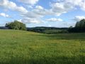
| + | I was walking through beautiful sunny fields of buttercups, my Geohash Droid was telling me I was only a few hundred metres from the hash, and after a few more Ramblers stiles I was within 100m. From there, the path headed south and away from the hash, but I had only to hop over a rusty five-bar gate and into another field of... whatever this green stuff is. Wheat? I don't do plants. The hash was about fifteen metres from the edge of the field, and I took the obligatory grinning photo. | ||
| + | |||
| + | Now, where did I park...? | ||
== Photos == | == Photos == | ||
| − | <gallery perrow=" | + | <gallery perrow="6"> |
Image:20150531bristolposter.png | The goal | Image:20150531bristolposter.png | The goal | ||
| + | Image:2015-05-31_bristolcar.jpg | We're not in Kansas any more | ||
| + | Image:2015-05-31_bristolcow.jpg | Impressive horns | ||
| + | Image:2015-05-31_bristolstile.jpg | A fortunate stile | ||
| + | Image:2015-05-31_bristolday.jpg | Miles and miles of buttercups | ||
| + | Image:2015-05-31_bristolgrin.jpg | Success! | ||
</gallery> | </gallery> | ||
== Achievements == | == Achievements == | ||
{{#vardefine:ribbonwidth|800px}} | {{#vardefine:ribbonwidth|800px}} | ||
| − | + | {{border geohash | latitude = 51 | longitude = -2 | date = 2015-05-31 | name = geeoharee }} | |
| − | |||
| − | |||
| − | |||
| − | |||
| − | |||
| − | |||
| − | |||
| − | |||
| − | |||
| − | |||
| − | |||
| − | |||
| − | |||
[[Category:Expeditions]] | [[Category:Expeditions]] | ||
| − | + | [[Category:Expeditions with photos]] | |
| − | [[Category:Expeditions with photos]] | ||
| − | |||
| − | |||
| − | |||
| − | |||
| − | |||
[[Category:Coordinates reached]] | [[Category:Coordinates reached]] | ||
| − | |||
| − | |||
| − | |||
| − | |||
| − | |||
| − | |||
| − | |||
| − | |||
| − | |||
| − | |||
| − | |||
| − | |||
| − | |||
| − | |||
| − | |||
| − | |||
| − | |||
| − | |||
Revision as of 20:37, 31 May 2015
| Sun 31 May 2015 in 51,-2: 51.8420975, -2.7544326 geohashing.info google osm bing/os kml crox |
Location
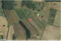
About as close to the England-Wales border as it could be. A field near Monmouth, north of Cottage Farm and south of Perth-Hir Grove. The river Monnow forms the border here, and the hash is in the middle of a >-shaped meander.
Participants
Plans
Finished my chores for the day and the sun is coming out, so why not try for the border achievement? Turn right off the B4347, park up and walk through fields, dealing with obstacles as they occur.
Expedition
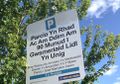
An uneventful drive from Cirencester towards South Wales, noting the 'Welcome to Wales' sign by the side of the road but unable to photograph it while driving. In lieu of that, I stopped in a supermarket car park and photographed one of the bilingual signs - proof I wasn't in England any more!
From the Monmouth Lidl I set off again, this time heading straight for the hash. Some experimentation on the B roads led me to conclude that the village of Maypole was probably as close as I'd get, and I parked the car on a convenient grass verge then headed down a farm track on foot.
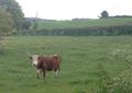
The first thing I came across was a field of very large cows with very large horns, and also one donkey. I needed to head east, but trespassing in (according to the sign) a field of prize English Longhorns seemed like a bad idea. I continued north -
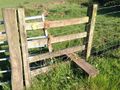
and found a stile! Not just a stile, but a stile with the yellow arrow symbol of a legal public footpath. At first I thought this was just good luck, til I noticed the little plaque on the upright: it had been put up by the Monmouth Ramblers. As a member of the Ramblers myself, I was glad I'd made that donation to the Paths Team last week.
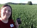
I was walking through beautiful sunny fields of buttercups, my Geohash Droid was telling me I was only a few hundred metres from the hash, and after a few more Ramblers stiles I was within 100m. From there, the path headed south and away from the hash, but I had only to hop over a rusty five-bar gate and into another field of... whatever this green stuff is. Wheat? I don't do plants. The hash was about fifteen metres from the edge of the field, and I took the obligatory grinning photo.
Now, where did I park...?
Photos
The goal
We're not in Kansas any more
Impressive horns
A fortunate stile
Miles and miles of buttercups
Success!


Achievements
geeoharee earned the Border geohash achievement
|